
In the wake of censorship and arrests, Hong Kong’s artists are quietly preserving protest materials through informal and digital means.
Read MoreUnderstanding Mecca’s Sacred Symbol: The Kaaba
Here is how the sacred site of Mecca in Saudi Arabia shapes faith, identity and worship in Islam.
Read MoreSingapore: The Green Metropolis
This ultra-modern city has become Asia’s most sustainable oasis.
Read MoreAt The Frontlines of Climate Change: The Middle East
The Middle East is bearing the brunt of climate change, heating up at twice the global rate and navigating devastating fallout from droughts, displacement and conflict.
Read MorePod Culture in Japan: Exploring the Quiet World of Capsule Hotels
A close-up tour of Japan’s high-tech sleep culture across three iconic cities.
Read MoreThe Cage Home Crisis in Hong Kong
Hong Kong's reputation as one of the most expensive housing markets in the world has led to more than 200,000 people living in cage homes, bedspace apartments likened to coffins for the living.
Read MoreThe Clean Energy Revolution Comes to Mongolian Ger Districts
A large portion of Ulaanbaatar’s population lives in traditional tent housing or gers and experiences some of the world’s worst pollution; sustainable energy may be the solution.
Read MoreAs Tehran Burns, Civilians are Caught in the Crossfire
Despite facing government censorship, the voices of Iranian residents reveal the fear and grief they endure under Israeli attacks.
Read MoreDubai on a Dime: A Budget Traveler’s Guide to the City of Gold
A practical guide to experiencing Dubai’s culture, food, and coastline without spending a fortune.
Read MoreThe Return of Child Marriage to South Asia
Families grappling with post-pandemic economic decline are turning to child marriages, undermining efforts to eradicate the practice.
Read MoreThe Ongoing Fight for LGBTQ+ Rights in Sri Lanka
As Pride Month approaches, 1.5 million Sri Lankans continue to fight against the longstanding criminalisation of homosexuality.
Read MoreGreta Thunberg Sets Sail to Gaza to Raise Awareness
As Israel’s blockade threatens famine, Thunberg and other activists launch a civilian flotilla with humanitarian aid, in protest.
Read MoreCartoonists Under Fire: The Fight for Free Expression in India
Political cartoonists in India are facing legal threats and online abuse for criticizing the government, revealing how satire itself is now under siege.
Read MorePaved Roads Not Necessary: Mongolian Road Trip
See temples, ride camels and enjoy desert views across the country.
Read MoreBali: A Recurring Chapter in My Travel Diary
Bali, with its intoxicating mix of vibrant culture, lush landscapes and tranquil seas, has always held a special place in my heart as a travel photographer and adventure seeker.
Read MoreRefusing Silence: Afghan Women Fight Back Through Prose
In the face of censorship and exile, Afghan women are creating new paths to keep their writing alive.
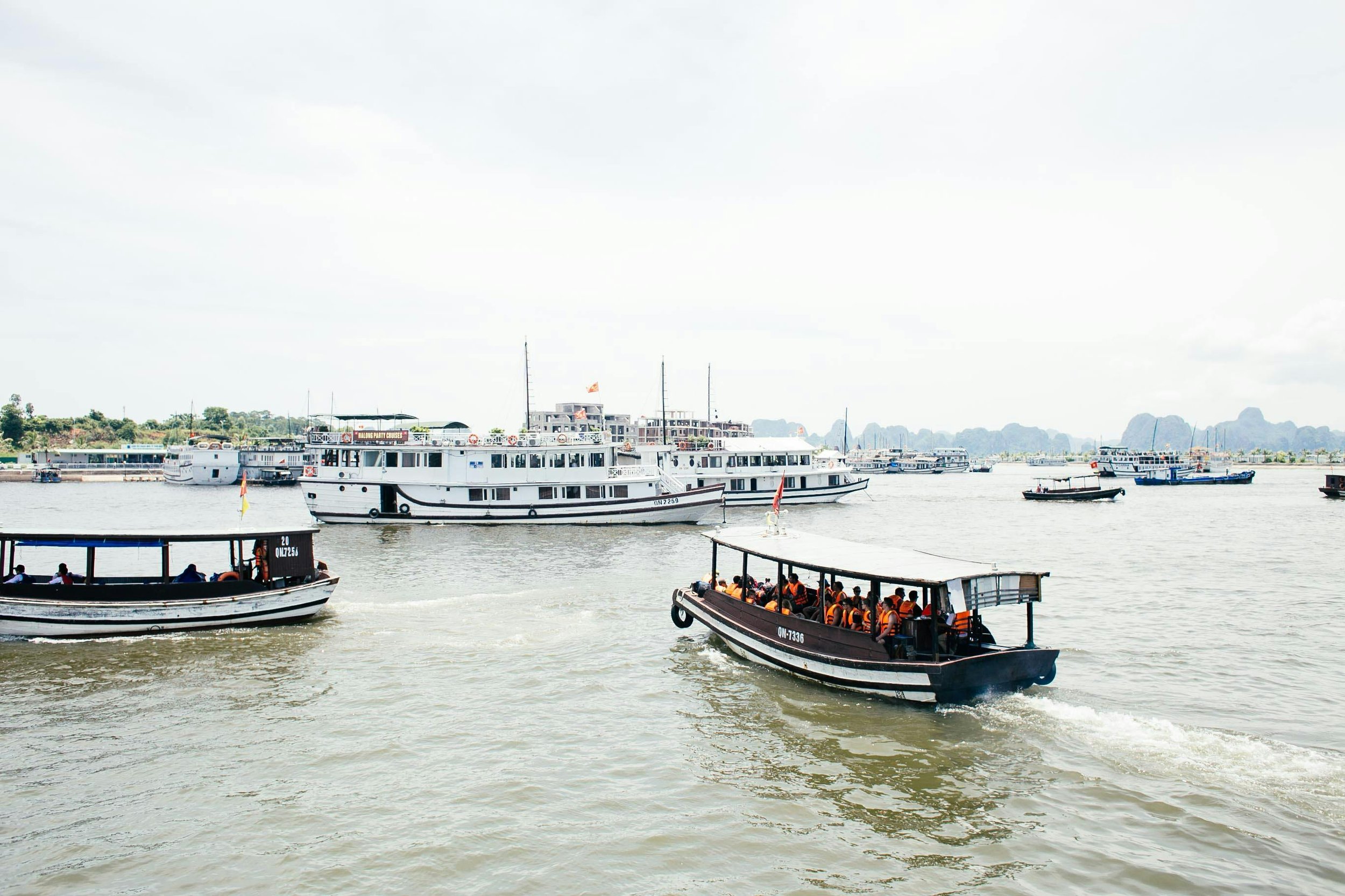
Read MoreVietnam’s Floating Markets Are Disappearing
Kennedy Kiser
Climate change, migration and tourism are reshaping life on the Mekong Delta’s rivers.

Bananas being traded at the Cai Be floating market in Vietnam. McKay Savage. CC BY 2.0.
In Vietnam’s Mekong Delta, boats once crowded with fruits, vegetables and steaming bowls of noodle soup now drift by in dwindling numbers. The iconic floating markets, such as Cai Rang in Can Tho, are in decline. Rising sea levels and saltwater intrusion have transformed daily life in the delta, threatening these vibrant centers of commerce and culture. These markets have been around for generations, and in the 1990s, were major trade hubs. But today, many of these boats are gone.
The decline is largely environmental. The Mekong Delta, which supplies half of Vietnam’s rice and a third of its GDP, is being overwhelmed by rising sea levels and saltwater intrusion. Climate change has intensified these threats, but human activity plays a role too. According to Environmental Law Alliance Worldwide, the overuse of groundwater, upstream hydropower dams and sand mining have all accelerated the erosion and subsidence of the delta. As saltwater continues to creep further on land, fertile rice paddies turn sterile and make freshwater harder to access. For boat vendors, this means fewer crops to sell, higher transportation costs and increasingly unreliable river routes.

Saltwater intrusion impacts farmland in Vietnam’s Mekong Delta. AFP. CC BY 4.0.
This decline in floating markets severely impacts local families, especially those who depend on the markets. Many vendors face dwindling incomes, leading to increased migration to urban areas in search of better opportunities. For instance, Nguyen Thi Thuy, a former farmer, was forced to leave her home due to saltwater intrusion and now works as a security guard in Ho Chi Minh City. Just a decade or two ago, her income from selling fruit on the water would have been enough to sustain a family.

Aerial view of storm surge over Thi Nai Bay, Quy Nhon, 1969. Bill Gann. CC BY 2.0.
Adding to this shift is an increasing generational divide. Many younger residents no longer see a future in river-based life. Education and tech-based jobs in the cities hold more appeal than selling local produce. In part, local governments are struggling to maintain these markets as an increasing number of vendors’ children choose to leave instead of inheriting the family business. As fewer people choose to stay, the floating communities face cultural erosion.
Passenger ferries at a harbor in Vietnam. Rachel Claire. CC0.
Tourism presents both challenges and opportunities for the preservation of floating markets. While increased tourist interest can provide economic benefits, it can also lead to cultural commodification and environmental degradation. Some markets that have become more tourist-oriented have, in turn, seen their authenticity and traditional practices diminish.
However, efforts are underway to balance tourism development with cultural preservation. In 2016, the Can Tho City People’s Committee approved the Preserving and Developing Cai Rang Floating Market project. This project aims to promote tourism and environmental hygiene while transforming Cai Rang into a “hub for the Mekong Delta’s agricultural products.”.
The future of Vietnam’s floating markets hinges on sustainable practices that honor their cultural significance while adapting to environmental realities. Community engagement, responsible tourism and environmental conservatism are key to ensuring the survival and success of these markets. As the Mekong Delta navigates the challenges of climate change, preserving the unique heritage of its floating markets remains crucial.

Boats at the Cai Rang floating market in Can Tho, Vietnam. pixiduc. CC BY 2.0.
For travelers hoping to experience the floating markets, visiting with care and intention matters. Cai Rang in Can Tho remains the largest and most accessible market. It is best visited early in the morning when trading is at its peak. Smaller markets like Phong Dien offer a local, less touristy atmosphere and are perfect for travelers seeking a quieter glimpse of daily life. Opt for small, locally operated boat tours and avoid bringing single-use plastics that could end up in the river. Supporting vendors by buying fresh produce or food dishes directly from their boats will not only enhance your experience but also help maintain these communities. By traveling mindfully, visitors can help preserve the spirit of Vietnam’s floating markets for generations to come.

Kennedy Kiser
Kennedy is an English and Comparative Literature major at UNC Chapel Hill. She’s interested in storytelling, digital media, and narrative design. Outside of class, she writes fiction and explores visual culture through film and games. She hopes to pursue a PhD and eventually teach literature! @kennedy_kiser
The Fight Against a Sinking City: Jakarta’s Sea Wall
Julia Kelley
While Indonesia’s government seeks to build a large sea wall to protect Jakarta from detrimental floods, criticism in the name of environmental and economic loss urges them to look for other solutions.
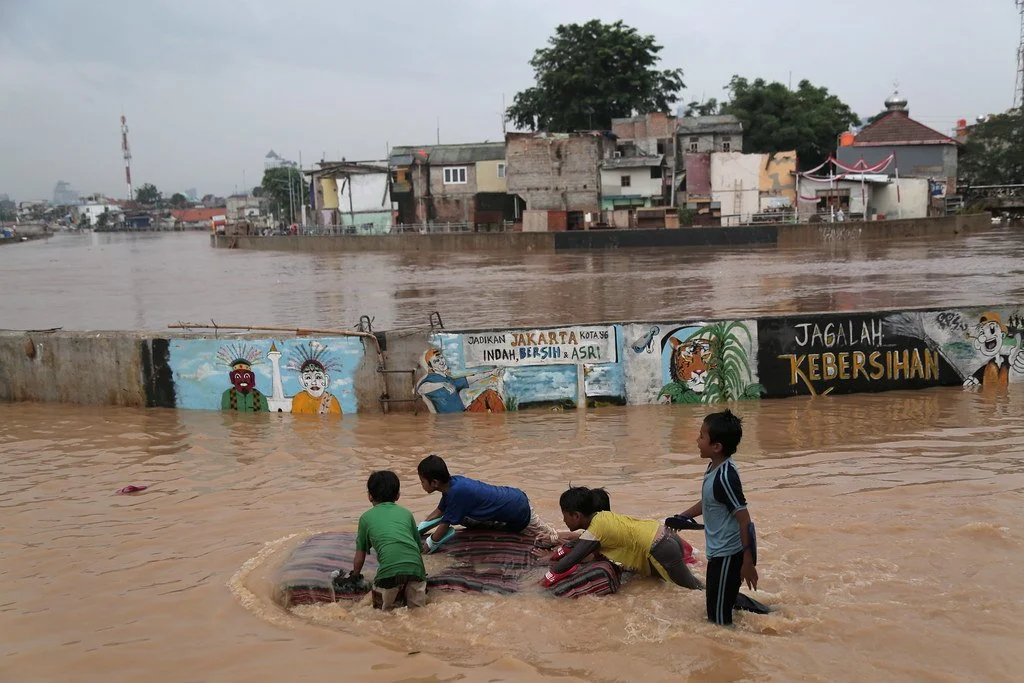
Flooding Ciliwung River in Jakarta Region. World Meteorological Organization. CC BY-NC-ND 2.0.
On the northwest coast of Indonesia stands Jakarta, the country’s capital and largest city. Sitting upon a low, flat alluvial plain with swampy areas, Jakarta is notably susceptible to major floods every few years from its multiple rivers and the adjoining Java Sea. This is made worse by excessive groundwater extraction and rising global sea levels, which have seen a worldwide mean increase of about eight to nine inches since 1880 due to global warming. Rapid urbanization, population growth and a change in land use have crowded more and more people into high-risk floodplain areas, leaving thousands displaced and large parts of the city submerged underwater during these natural disaster events. Although the Indonesian government built a coastal wall in 2002 to combat this, its collapse in a storm only five years later renewed the call for protective measures against destructive flooding. A new mega-project began in 2014, outlining both the construction of a new 29-mile-long sea wall and the so-called “Giant Sea Wall.” This “Giant Sea Wall,” a 20-mile-long artificial island shaped like a Garuda bird, Indonesia’s national symbol, will not only block storm surges but is also planned to contain homes, offices and recreational facilities.
This massive undertaking officially kicked off in February 2025 and is said by supporters to be key in dealing with the country’s land subsidence and flooding. Both President Prabowo Subianto and Minister of Infrastructure and Regional Development Agus Harimurti Yudhoyono claim that the project could save the government billions of dollars in disaster mitigation over the following 30 years. Despite this optimism, critics have come out against the large project, citing an array of detrimental economic and environmental issues that could result from construction. For example, many have noted how the proposed solution does not address the over-extraction of groundwater, which comes from excessive use by industrial and economic activities. In addition, the sea wall could disrupt marine biodiversity and, subsequently, the fishing industry, one of Indonesia’s strongest monetary sources. According to Maleh Dadi Segoro, a coalition of environmental and social groups, the sea wall would potentially narrow and close fishing catch areas, disrupting marine ecosystems and threatening the livelihoods of those who depend on them for food and income. Jakarta already faces low water quality in its rivers and canals, causing sewage and a lack of proper sanitation. Closing off Jakarta Bay for this sea wall, critics say, would turn the water into a “septic tank” or “black lagoon,” which necessitates a stronger water sanitation system immediately.
Controversy stirred up by the sea wall proposal has thus solicited alternative solutions. There has been an interest in using the water to its advantage, rather than working against it. This would entail diverting surplus waters, including that from floods, to surrounding farm areas where it could be stored. Restoration has also been widely proposed, as described by professor of oceanography Alan Koropitan for The Guardian: “If, instead, we can restore the bay and its polluted waters, that would mean something good for civilization in Indonesia.” Among all these suggested plans, environmental, social and economic protection are set at the center, urging the Indonesian government to rethink its monumental and costly plan.
GET INVOLVED:
Those looking to help support those affected by floods and flood prevention in Indonesia can do so by checking out relief organizations, such as The International Federation of Red Cross and Red Crescent Societies’ Disaster Response Emergency Fund, Peace Winds and Mercy Corps, all of which provide immediate and long-term support. Furthermore, individuals interested in combating sea level rise can look into taking actions that counter global warming, including using renewable energy, reducing greenhouse gas usage, considering electric vehicles, recycling, decreasing food waste, keeping the environment clean, or getting involved with local communities and government to organize plans and legislation.

Julia Kelley
Julia is a recent graduate from UC San Diego majoring in Sociocultural Anthropology with a minor in Art History. She is passionate about cultural studies and social justice, and one day hopes to obtain a postgraduate degree expanding on these subjects. In her free time, she enjoys reading, traveling, and spending time with her friends and family.
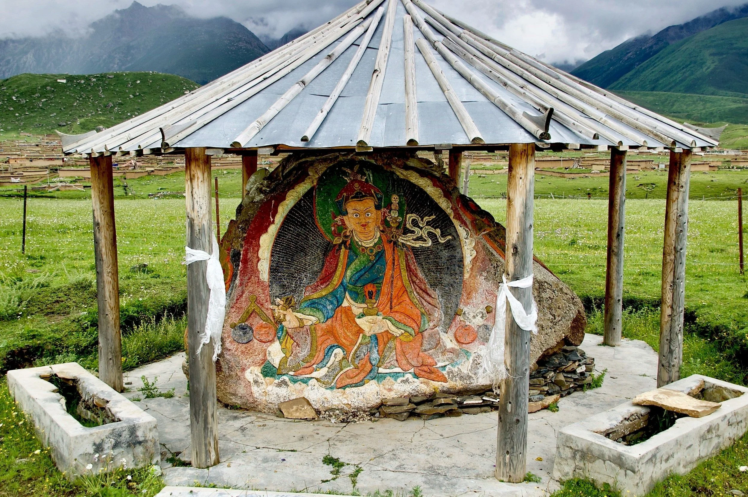
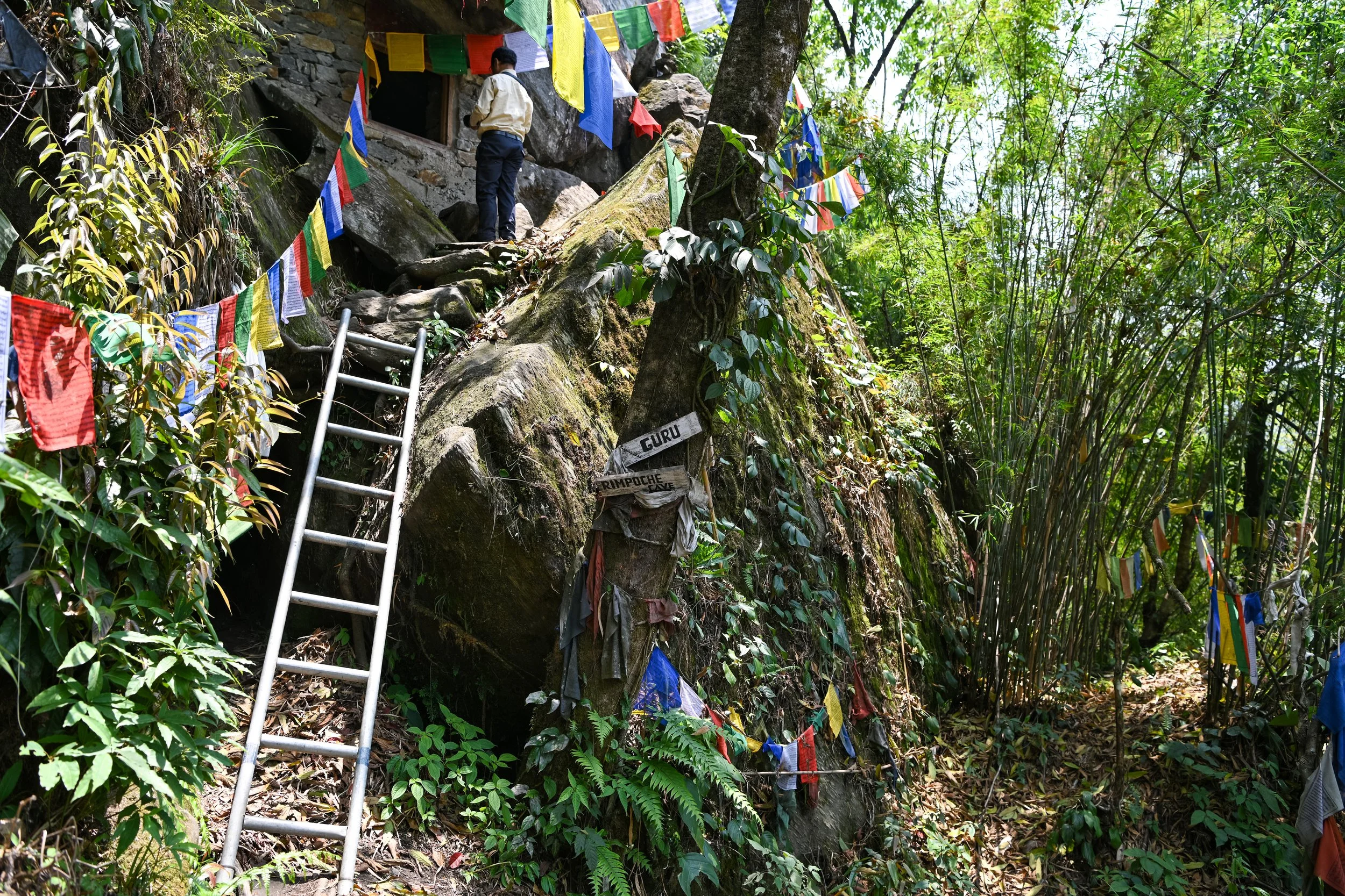
Buddhism in Tibet and the Sacred Dzogchen Caves
Julia Kelley
Spotting the landscape of Eastern Tibet are the Sacred Dzogchen Mountain Caves, natural formations that have been revered for centuries as sites of historic Buddhist enlightenment.
Entrance to Pilgrimage Road in Dzogchen Monastery. Mario Biondi. CC BY-SA 4.0.
Found in the mountains of Eastern Tibet, also known as Kham, is the Rudam Valley. Here, 4,000 meters (13,123 feet) above sea level, plateaus imprinted with lakes and waterfalls are home to a population of more than 850,000 people. Tibetan Buddhist monasteries dot the landscape, reflecting the valley’s religious significance and contributing to its diverse culture. Most notably, in the Holy Dzogchen Area, surrounding communities have their own cultural expressions marked by distinct seasonal ceremonies and local traditions. The population in the Holy Dzogchen Area widely practices Vajrayana Buddhism, a form of Tantric Buddhism that emphasizes one’s potential to achieve enlightenment in a single lifetime rather than through many. This doctrine is taught in the Dzogchen Monastery, which offers a religious education to young people who desire a monastic life and serves as the main monastery for hundreds of branches throughout Tibet.
Guru Rimpoche Cave. Anjan Kumar Kundu. CC BY 4.0.
The Holy Dzogchen Area’s beauty and devout culture are further exhibited through its natural cave complex, known as the Sacred Dzogchen Mountain Caves. From mountains to valleys, the thousands of caves that make up this system are a powerful feature of the local religious practice. The significance of these natural formations can be traced back to a series of influential Dzogchen Vajra masters who lived in them to reach enlightenment. Buddhism was first introduced to Tibet in the 7th century C.E., and was not translated until 641 C.E., when Tibetan king Songtsen Gampo unified the region and converted to Buddhism with his marriage to two Buddhist princesses. The king also invited important Buddhist masters, Padmasambhava and Shantarakshita, to teach the doctrine throughout the country. This included instruction in Dzogchen, an advanced system of meditation that gives the Holy Dzogchen Area its name. These leaders and their students utilized the isolated and serene nature of the surrounding caves to facilitate their enlightenment. The Snow Mountain caves, Shinje and Senge Druppuk caves, and Canyon caves are only a few of the sites that have become revered for their religious history, as Vajra masters such as Shri Singha and Padmasambhava lived and meditated in their solitude to achieve high realization.

Sacred Cave Interior. slobo486. CC BY-NC-SA 2.0.
This long history as a Buddhist religious symbol has made the Dzogchen cave system a common pilgrimage route. Beyond the caves, the entirety of the Dzogchen Area has become associated with enlightenment due to these countless sacred sites. Many pilgrims first journey to the Dzogchen Monastery, where they can practice retreats and meditations in the monastery’s retreat center. From there, devotees travel to surrounding temples and sacred caves, walking in the footsteps of Buddhist leaders. On their blog, Yowangdu Experience Tibet, travelers Lobsang and Yolanda write about their personal experience with the pilgrimage. They describe one of the caves as “a sacred spot where the great Buddhist master had honed his wisdom and compassion in decades of meditation” and where “he had written the text that had moved and inspired” them, echoing Dzogchen followers’ continued belief and devotion to these holy spaces.
Julia Kelley
Julia is a recent graduate from UC San Diego majoring in Sociocultural Anthropology with a minor in Art History. She is passionate about cultural studies and social justice, and one day hopes to obtain a postgraduate degree expanding on these subjects. In her free time, she enjoys reading, traveling, and spending time with her friends and family.
Forced Uyghur Labor in China’s Seafood Industry
Uyghur people in China are subjected to forced labor in the seafood industry, enduring brutal conditions and human rights abuses on fishing vessels and in processing plants.
Read More