7 Caves, Temples and Cities Carved in Mountains

These ancient sites were once carved into the surrounding landscape and continue to stand today.

Created at a time when construction vehicles and advanced building tools did not exist, these caves, temples and cities demonstrate the craftsmanship of their ancient peoples all over the world.  

1. Petra 

Petra, Jordan

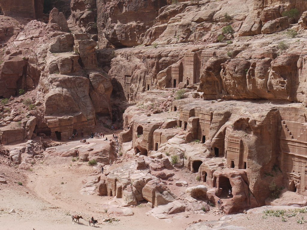
Petra, which is also known as “Rose city” for its pink-hued rock carvings, is located between the Red Sea and the Dead Sea in Jordan. The archaeological site is home to several rock-cut temples and tombs, including Al Khazneh, Al-Deir, the Palace Tomb and Urn Tomb. Today this carved site is both a UNESCO World Heritage Site and one of the New 7 Wonders of the World.

2. Longmen Grottoes 

Luoyang, China 

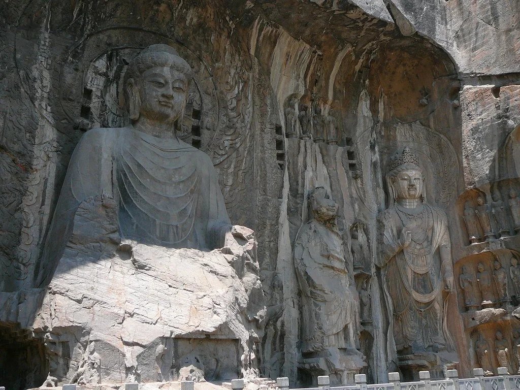
Longmen Grottoes. Dericafox. CC BY-NC-ND 2.0

Considered one of the best examples of Chinese Buddhist art, the Longmen Grottoes date back to the 5th century. The site contains more than 2,000 artificial caves and over 100,000 Buddhas carved into the limestone cliffs of the Xiangshan and Longmenshan mountains. The Longmen Grottoes cover an area of 30,000 square meters and the statues range in size (0.7 in- 53 ft). The site became a UNESCO site in 2000. 

3. Ellora Caves 

Maharashtra,India

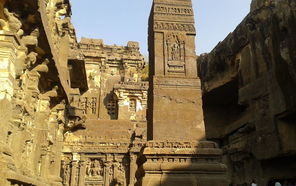
Ellora Caves: Kailasanatha Temple. DdasedEn. CC BY-NC-ND 2.0

Stretching more than a mile long in distance, the Ellora cave temples date back to the 5th century. Located in Maharashtra, India the 34 caves are dedicated to Buddhism, Hinduism and Jainism. Designated a UNESCO World Heritage site in 1983, the Ellora Caves were hand carved into hillside rock.   

4. Mesa Verde National Park 

Montezuma, Colorado

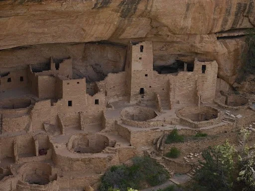
Mesa Verde National Park. Usareisetipps. CC BY-SA 2.0

Within Colorado’s Mesa Verde National Park you’ll find the largest archeological preserve in the US. Located in Montezuma County and occupying 81 square miles, the more than 4,000 Pueblo Indian sites date back to the 6th century. As well as 600 cliff carved dwellings including the famous Cliff Palace and Long House. It is frequently visited by mountain lions, elk and bears as well as lizards and snakes which roam the National Park. 

5. Goreme National Park 

Nevşehir, Turkey

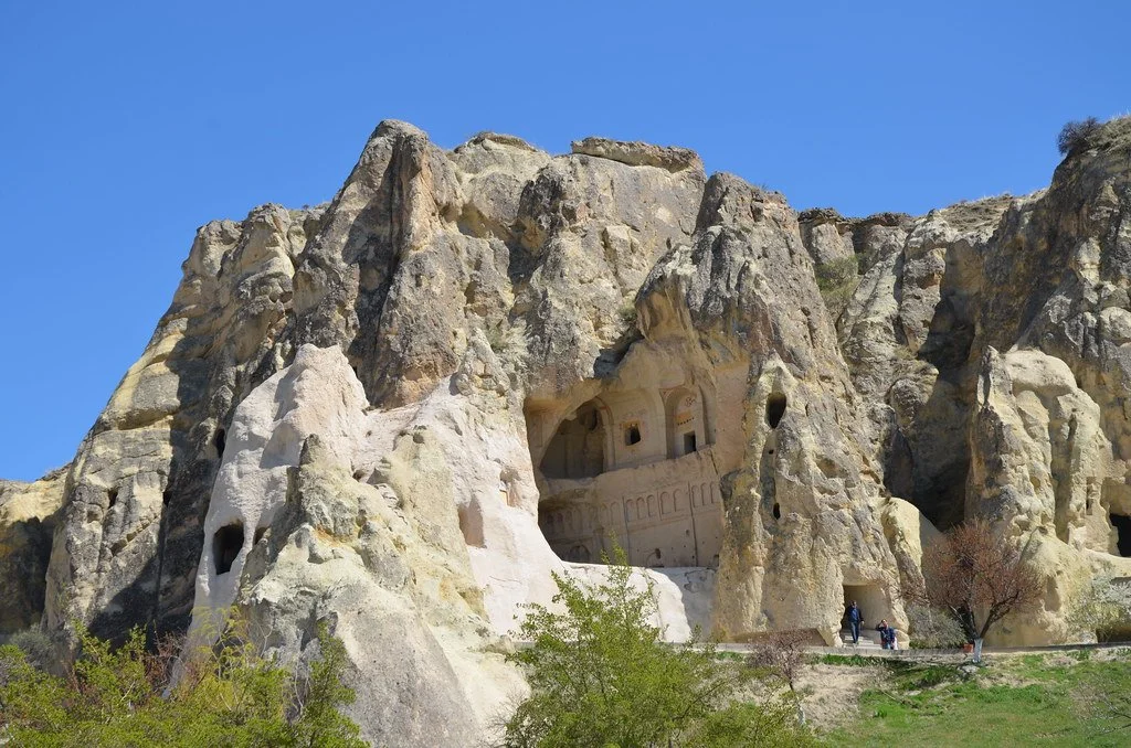
Sculpted by erosion, the Göreme National Park is in Cappadocia, Turkey and contains rock-hewn sanctuaries, houses, monasteries, churches and underground cities. These were inhabited and built in the 4th century, Neolithic pottery and tools found in Cappadocia attest to an early human presence in the region. Clay tablets recovered from the remains of an Assyrian merchant colony at Kanesh are among the oldest written documents discovered in Turkey. 

6. Abu Simbel 

Aswan, Egypt

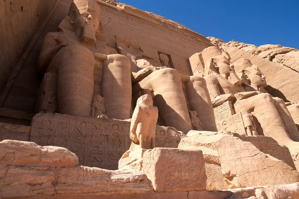
An ancient temple complex, Abu Simbel was built by Egyptian King Ramses II to intimidate his enemies and seat himself amongst the gods. The 66-foot seated figures of Ramses are set against the recessed face of the cliff, two on either side of the entrance to the main temple. Carved around their feet are small figures representing Ramses’ children, his queen, Nefertari, and his mother, Muttuy. The temples were unknown to the outside world until their rediscovery in 1813 by the Swiss researcher Johann Ludwig Burckhardt. 

7. Lycian Tombs 

Anatolia, Turkey

The 4th century Lycian tombs of Turkey contain carved tombs into the side of the region’s mountains, demonstrating a form of ancestral worship. More than a thousand tombs are there  today varying in many intricate styles. Some with Romanian columns and other decorative features. The Lycian people believed the dead were carried to the afterlife by winged creatures, hence helping the process by laying them to rest in high cliffside tombs. 


Jennifer Sung

Jennifer is a Communications Studies graduate based in Los Angeles. She grew up traveling with her dad and that is where her love for travel stems from. You can find her serving the community at her church, Fearless LA or planning her next trip overseas. She hopes to be involved in international humanitarian work one day.

10 National Parks to Visit Outside the US

While most people associate National Parks with the US, there are amazing National Parks to visit around the world. Check out glaciers, tropical wetlands, the oldest desert in the world in these parks in Iceland, Namibia, Thailand, India and more.

Read More

Inside the Lives of the American Amish  

The Amish are known for their conservative beliefs and rejection of modern technology. Today, more than 300,000 Amish live in the United States.

Teen Returning Home From Work. Melnee Benfield. CC BY-NC-SA 2.0

The Amish Church originated in Europe in the seventeenth century following a split from the Mennonite Swiss Brethren in 1692. This split was due to a disagreement about the treatment of members who had been found guilty in breaching the doctrine. To escape persecution, the Amish migrated to Pennsylvania in the 1730s. Today the population is an estimated 300,000 people in more than 30 states and is steadily growing due to the Amish belief that children are a blessing from God. The majority of the Amish community (62 percent) live in Pennsylvania, Ohio and Indiana. They are Christian believers who have isolated themselves from modern society and live in rural areas of the United States. They do this to keep their community from being influenced by outsiders, who they refer to as the “English.”

Family is the most important social unit in Amish culture. On average, families have seven children, although larger family units than this are common. Chores are divided traditionally by the gender binary, with girls staying and helping their mothers manage the home. If they decide to work outside the home, it is within the Amish community doing jobs like sewing, selling food in local stands or stores, waitressing, midwifing or nursing. Boys work alongside their father in farms, construction, crafting furniture, raising livestock and auctioneering. On days when they are not working, the Amish turn to sports like baseball, volleyball and basketball. Board games are also very popular among the Amish household, as well as fishing, hunting and being in community with friends and family. 

The Amish generally eat foods produced in their own gardens or on their farms. As a rule, they do not eat processed, store-bought foods. Homegrown fruits and vegetables, eaten fresh, canned or frozen, play an important part of the Amish diet. Vegetables often found in their meals include peas, corn, zucchini, beets, beans and rhubarb. Meals are designed to sustain hardworking lifestyles. The women in the community are known to bake cakes, pies, cookies and bread. An Amish dessert favored by many is Shoofly pie, typically composed of flour, brown sugar, water, spices and egg. The pie is topped with crumbs and served in a flaky pie crust. Shoofly pie is similar to coffee cake, but with a gooey molasses bottom. 

Kids of All Ages Playing Baseball. Bob Jagendorf. CC BY-NC 2.0

Education in the Amish community begins at the age of six (first grade) and culminates at 13 (eighth grade). Children are taught in a one-room schoolhouse, usually within walking distance of their home. The classroom is composed of 30-35 children, many of which are siblings or cousins. The day begins with Bible reading, hymn singing and reciting the Lord’s Prayer. At the end of the morning routine, the basics are taught: writing, math, history, arithmetic and English. The students’ first language is Amish German dialect, then English is learned at school. The teacher or teacher’s aide will circulate the room teaching individual grades while the other grades read or prepare for their time of teaching. Higher education is discouraged, as it could lead to leaving the Amish community and influencing others to do the same. Amish children are exempt from state compulsory attendance beyond the eighth grade based on religious principles.

The Amish reject modern technology as it can open the door to temptations and change their traditional lifestyle. Instead, they choose to live simple lives and are self-sufficient. The Amish farm and produce everything they own and ride a horse and buggy or a bike to travel around the community. However, there is a time when Amish youth can decide whether or not they would like to continue living within the community. This is a season where rumspringa, a German term for running around, takes place. At the age of 16, parents allow the teens to fully experiment with the outside world and activities, which would otherwise be condemned and result in shunning. Due to the fact that individuals aren’t baptized, teens are not yet under the church authority. This is part of the reason why they are given a pass. This experience lasts two years and 90 percent of teens return home. 

Amish Family on a Horse and Buggy. Brucedetorres. CC BY-PDM 1.0

After arriving more than three centuries ago, the Amish have sustained a private life from the outside world. Not allowing many into their community has resulted in the preservation of their beliefs and isolation. The Amish continue to live in the US with two new recent settlements, Argentina and Bolivia.


Jennifer Sung

Jennifer is a Communications Studies graduate based in Los Angeles. She grew up traveling with her dad and that is where her love for travel stems from. You can find her serving the community at her church, Fearless LA or planning her next trip overseas. She hopes to be involved in international humanitarian work one day.

South India on Foot: Breaking Stereotypes One Step At a Time

We all have images in our minds about faraway places and the people that occupy them. Whether accurate or not, these ideas are often put in our heads by the news we consume, school textbooks or social media.

Dawn Lwakila exploring bush-trails in India’s rural Tamil Nadu

I’m one of those folks who likes to go and see for herself. I’ve spent the past 30 years living and traveling across four continents. My roots are in northern Canada—Yukon to be exact. Many would think this to be the absolute opposite in every way from my current home in the big bustling city of Chennai, the capital of India’s southern state, Tamil Nadu. Fortunately, I live on the outskirts of the city which enables me to get into the countryside fairly quickly. I believe it is my small-town roots that have allowed me to feel comfortable and at home in rural settings here in India.

Ganesh temple in Tamil Nadu’s Chengalpattu District.

I love wandering the dreamy hills of Munnar, Kerala.

I’m a wanderer at heart, and I am happiest walking from village to village, hilltop to hilltop. Some days I only walk 15km and other days I may walk more than 40km. I take backroads and bush trails, all the while documenting what I find beautiful with a few photos and videos, posted almost daily on my Instagram. Photography is a wonderful form of storytelling and the tale that I aim to tell isn’t often heard. I have been warned countless times not to walk alone in India. From mainstream media, I have been inundated with images representing India as a place of filth, overcrowding and crime. This has not been my experience.

Mambakkam Lake, Tamil Nadu. I love to leave my house while it’s still dark so that I can reach these magnificent locations at sunrise.

My secret swimming hole.

Over the past several years I have walked through much of South India exploring my home-state of Tamil Nadu as well as Kerala, Karnataka and Andhra Pradesh. There has not been a single incident where I felt threatened or unsafe. Rather, I have been greeted with nothing but kindness and hospitality. I have walked through bustling cities, endless kilometers of road and countless areas of pristine natural beauty, enjoying the entire place all to myself.

Following back-roads in Chengalpattu, Tamil Nadu.

Golden buffalo babies at sunrise.

I choose to go to locations that are off the beaten path. I search Google Maps for interesting features in the landscape and simply go check it out. One of my favorite things to do is follow small backroads from village to village. I cut through farmland and learn when each of the crops is planted and harvested. I find wondrously forgotten temples, tucked away in forests or on hilltops, unvisited except by a few folks from nearby settlements. I prefer to see life slowed down and simplified. For me, rural India offers the most incredible scenery where I am always bound to meet kind-hearted people who offer me smiles, refreshments and places to rest my tired feet.

Misty morning, cutting through the forest at sunrise to find a hidden lake.

Enjoying the coast of Kerala after trekking the highlands.

I feel so grateful for the sense of pride in the beauty of South India my photography has sparked. Many people, especially in the cities of India, have their eyes fixed on international destinations. When they look at tourism in India they often head to large resort towns or famous national parks. There is a sense of surprise when people see my images and learn of places in their own backyards that rival these famous destinations. I have received both local and national media coverage, which boggles my mind, but I guess this is because I’m doing something that the majority of women are not doing and, with a fresh set of eyes, I’m showcasing humble locations that are largely overlooked.

The comment I get the most from people who have never visited India is, “This is not how I pictured India to be.” For me, this is the greatest compliment, as it means that people are reevaluating the impressions they have about this country that is so dear to my heart.

Muttukadu Backwaters at sunrise. This is an important nesting and feeding area for both local and migratory birds.

An old neglected temple in Kanchipuram District of Tamil Nadu.

I like to approach new places with the idea that I’m a simple student and that those around me have something of value to offer. Trying to absorb as much as I can, I chose to share through my photography what intrigues and inspires me. I look for a sense of belonging and what connects me to others. Over the years I have learned that despite the superficial things that mark our differences—language, religion, politics—there is much more that unites us as humans. Step by step I find that all my previous notions about a place are left behind, replaced by a much more balanced and authentic understanding.

Banyan tree. Andhra Pradesh.

Peaceful moments walking from village to village.

Nothing compares to making my way through a new place on foot. The world slows right down and all the little details come into view. Precious moments that could never be captured any other way have become my daily reality. I am grateful for this journey and my hope is that it will inspire others to get out there and explore in a way that allows them to feel intimately connected to the places they visit. 

Feel free to stay up to date with my adventures. You can find me on Instagram @dawned_onme or on Youtube: Wander Woman.


Dawn Lwakila

Dawn continually takes the path less trodden, both figuratively and literally. She loves to really live in a place and grow some roots there — as well as a good wander and the freedom to explore. Canada is her homeland, but her heart and soul are scattered across the globe. She has journeyed through over 30 countries and still has an ever-growing bucket list of new places to experience. She is currently based out of Tamil Nadu India.

7 Stunning Caves Worth Exploring

Though caves often hold a fearsome reputation, they have a myriad of captivating natural features and intriguing histories. 

Caves often get a bad reputation: cold, dark, damp and uninteresting, or even frightening. In reality, caves offer snapshots of history, unusual natural structures, and examples of remarkable biodiversity. There are thousands of caves on Earth, and even more that are yet to be discovered. Each cave is unique, with specific natural formations that cannot be found anywhere else. Here are seven incredible caves to add to your list of must-see sights. 

1. Reed Flute Cave, China 

Called “the Palace of Natural Art,” Reed Flute Cave is known for its impressive stone curtains and pillars. Reed Flute Cave is located just 3 miles from downtown Guilin, China, and has been an attraction for centuries. Seventy-seven inscriptions of poems and travel descriptions can be found around the cave, and the oldest dates back to 790 A.D., the era of the Tang dynasty. There are inscriptions from the Tang, Song, Yuan and Ming dynasties, written by monks, poets, scholars and tourists from all over China. Today, the cave is lit by many multicolored lights hidden in its natural cracks and crevices, which cast a bright rainbow glow around the dark space, giving cave visitors a surreal and breathtaking experience. The cave was forgotten for years until its rediscovery in 1940, when a group of Chinese refugees stumbled upon it while fleeing from Japanese forces. During World War II, the cave’s large chamber, called the “Crystal Palace of the Dragon King,” was used as a bomb shelter. The cave regained popularity after its rediscovery at the end of the war, and was officially opened to the public in 1962. 

2. Waitomo Glowworm Caves, New Zealand 

Visitors to the Waitomo Glowworm Caves will take a trip into the past by exploring a cave over 30 million years old. The cave, located in Waitomo on the North Island of New Zealand,  is praised as one of New Zealand’s best natural attractions. It contains an underground river, towering rock formations, and thousands of shimmering glowworms. The Glowworm Caves have been an attraction for over 130 years. These limestone caves formed at the bottom of the ocean millions of years ago. Local Maori communities knew about the caves, but they were first explored in 1887 by Maori Chief Tane Tinorau and English surveyor Fred Mace. After discovering the natural beauty of the caves, Chief Tinorau opened the caves to tourists in 1889. Many of the guides for tours today are descendants of Chief Tinorau. Guides take visitors on walking tours through the caves, as well as boat tours through the glowworm grotto. These boat tours take visitors to the center of the grotto, where they can look up in awe at the luminescent glowworms covering the cave walls and ceiling.  

3. Mendenhall Ice Caves, Alaska

Just 12 miles outside downtown Juneau lies Mendenhall Glacier, known as the “Glacier Behind the Town.” Inside the glacier are the Mendenhall ice caves, passageways formed by water flowing through the glacier. These caves vary in size from tiny openings visitors have to squeeze through to giant caverns. Mendenhall Glacier was first explored in 1794 by Joseph Whidbey, a member of the British Royal Navy serving on Capt. George Vancouver’s 1791-95 expedition of the Pacific Northwest coast. To visit the caves, travelers can hike through the Tongass National Forest and then across the glacier, or they can canoe across Mendenhall Lake to the glacier. Both options offer breathtaking views of the glacier and surrounding landscapes, and both are somewhat strenuous but well worth the effort. Inside the caves, visitors are immersed in the cool blue shades of light coming through the glacier and can explore ever-changing ice formations. The caves change as the ice melts, so each visit to the Mendenhall ice caves is unique. The presence of the caves is also inconsistent and typically seasonal, so visitors should be sure to check on the status of the caves before planning a trip. 

4. Barton Creek Cave, Belize

To discover the wonders of Barton Creek Cave, visitors will have to board a canoe. Barton Creek Cave is located east of San Ignacio along the western edge of Belize. It is a wet cave because it has a cave river running through it, and paddling along this tranquil river is the only way to take in the cave’s majesty and history. It is the largest river cave in Belize and contains evidence of ancient Mayan culture. The cave is natural, but archaeologists have identified a number of areas they believe were purposefully modified by the Mayans to improve access to the cave. These modifications include natural formations of flowstone broken to allow access to a rimstone pool and holes drilled by Mayan tools, likely to serve as handholds or to attach climbing ropes. Ten ledges made by the Maya line the cave walls, where archaeologists have discovered thousands of pottery shards, most of which are from large jars called ollas, and a number of stone tools. These discoveries have helped archaeologists determine the use of the cave during Mayan times; it was likely the site of ritual activity and worship. The Maya regarded caves as sacred sites, and the artifacts found in Barton Creek Cave reflect this view. Tours through the cave offer visitors the opportunity to witness incredible natural formations and to learn how the ancient Mayans interacted with the cave. 

 5. Hang Son Doong, Vietnam 

For travelers who want to explore a cave but worry about darkness and small spaces, Son Doong Cave in central Vietnam is the perfect place to visit. Son Doong has the largest cross section of any cave in the world, reaching over 5 miles long, 650 feet wide and 490 feet tall. In some areas, the limestone ceiling of the cave grew weak and collapsed, creating huge skylights and allowing areas of lush vegetation to grow inside the cave. It was formed millions of years ago by the Rao Thuong River eroding limestone. Son Doong Cave was initially discovered in 1990 by a local man named Ho Khanh, who stumbled upon the entrance while searching the area for food and timber. He then returned home and no further exploration of the cave occurred until Howard and Deb Limbert, members of the British Cave Research Association, heard Ho Khanh’s story and urged him to find the cave again. In 2008, he successfully rediscovered the cave, and a survey was conducted by Howard Limbert and a group of British cavers. The cave opened to the public in 2013. Visitors are sure to be impressed by the sheer size of the cave, as well as its natural formations, river and distinctive vegetation growth. 

6. Puerto Princesa Underground River, Philippines

Located on Palawan, the westernmost island in the Philippines, Puerto Princesa Subterranean River National Park is home to old-growth forests, wildlife and an expansive limestone cave system. The Puerto Princesa Underground River, as it is commonly known, flows for over five miles through beautiful caverns and eventually meets the sea. Visitors can take underground river tours on paddleboats to see the stunning cave formations and limestone cliffs, as well as a variety of native animal species. There are records of the Puerto Princesa Underground River dating back to 1898, but it is believed to have been known to early inhabitants of the Philippines and investigated by foreign explorers prior to that time. The area was established as an official attraction in 1971, and the cave system is still being explored. In 2010, researchers discovered a large cave dome above the underground river, with more river channels and access to an even deeper cave. The Puerto Princesa Underground River offers an abundance of fascinating natural formations to explore. 

7. Shell Grotto, England 

Shell Grotto is one of England’s most mysterious sites, encompassing over 70 feet of tunnels under the seaside town of Margate. These caves were discovered by chance in 1835, when a man excavating his new land stumbled upon them. Sprawling mosaics made of mussel, oyster, whelk and cockle shells cover every wall of the tunnels. Historians are unsure of who built Shell Grotto, or why. Theories range from Shell Grotto being a place of worship to a simple display of extreme wealth to the meeting room of a secret society. The elaborate shell designs offer little explanation, displaying swirling patterns that can be interpreted as a number of different things. Shell Grotto is a tremendous work of art, and the questions surrounding its origin and purpose add a layer of intrigue that draws visitors from around the world. 


Rachel Lynch

Rachel is a student at Sarah Lawrence College in Bronxville, NY currently taking a semester off. She plans to study Writing and Child Development. Rachel loves to travel and is inspired by the places she’s been and everywhere she wants to go. She hopes to educate people on social justice issues and the history and culture of travel destinations through her writing.

Spain’s Graffiti Phenomenon

Spain is known for the street art that decorates major cities and towns all over the country, with multiple Spanish street artists reaching global acclaim. The street art phenomenon is especially significant not only for the identity it gives to Spain, but also for its relation to contemporary culture and expression. 

Graffiti in Alicante, Spain. Photo by Ralph (Ravi) Kayden.

Mural in Madrid, Spain. Photo by Nancy O'Connor.

When walking the streets of Valencia, Spain, nowhere is the graffiti more prolific than Barrio Carmen, the historic district of Valencia. Tall buildings along winding stone alleys are adorned with color: depicting abstract images, portraits, and scenery reminiscent to that of the artists of the Escuela de Bellas Artes. Property owners often commission artists to decorate the entrance to their buildings, establishing a connection to the culture of artistic exhibition that exists within the city. Valencia is just one home to the countless networks of street artists across Spain: graffiti peppers the streets and surfaces of major cities, villages, and neighborhoods alike across the nation. 

In Barcelona and Madrid, the real graffiti phenomenon exists not in the streets, but underground: along the sides of metro cars. Given the costs of cleaning and repairing painted cars, this form of graffiti is revered as the most risky, and the most thrilling. Barcelona has begun to heighten its police presence in the metros to prevent vandalism, but this measure has only served to make the artists more crafty. Rappelling through vents, jumping fences, and running from the police have become commonplace in the laundry list of a street artist’s activities. 

Saville Street, Saville, Spain. Photo by Look Up Look Down Photography.

The two principles that unite the diverse network of graffiti artists throughout Spain are anonymity and adventure. In this way, street art becomes an equalizing force for expression. Of the thousands of graffiti artists throughout Spain, there exists no single class or personal affiliation. From this anonymity arises solidarity; artists sometimes work in teams or paint in recognizable styles, but rarely is the actual identity of an artist public. 

Regarding adventure, José Sánchez, an anthropological researcher at Pompeu Fabra University, describes that from graffiti, artists find both a sense of belonging as well as adrenaline. There is, then, a dual impetus: to create some sort of permanence through visual expression, but also for the rush of the moment: the danger of painting in precarious situations, or of attempting to evade vandalism charges from the police. Sánchez offers the notion that the street art phenomenon arises as a microcosm for a contemporary society entrenched in immediate gratification, tactile pleasures, and hedonism, which Sánchez identifies mostly as the impact of youth culture. This explanation, however, seems to only cover part of the multifaceted nature of graffiti and its specific mode of public speech. 

Mahón, Menorca, Spain. Photo by JR Harris.

One prolific street artist from the Gijon region of Northern Spain, who goes by the moniker “Señor X,” has become widely known as “Spain’s Banksy,” in reference to the mysterious British graffiti artist who has gained significant global acclaim in recent decades. Señor X’s work is focused on social commentary: the vast majority of his murals are anti-capitalist and anti-establishment. Señor X’s dynamic portfolio represents just part of the larger body of street art created in protest. 

Furthermore, the debate over graffiti as street art versus graffiti as vandalism is just one feature over the larger question of legitimate protest. Art and visual expression have long been means of protest: Picasso’s Guernica, one of the most renowned pieces in the Spanish canon was painted in response to the bombing of the civilians of Guernica, Spain during the Spanish Civil War. The murals of artists such as Señor X represent many of the same sentiments and involve similar artistic meticulousness, but are illegal, rather than revered. Nonetheless, street art remains an integral part of identity and expression within Spain, and furthers discussions as to the nature of protest and youth culture globally.


HALLIE GRIFFITHS

Hallie is an undergraduate at the University of Virginia studying Foreign Affairs and Spanish. After graduation, she hopes to apply her passion for travel and social action toward a career in intelligence and policy analysis. Outside of the classroom, she can be found, quite literally, outside: backpacking, rock climbing, or skiing with her friends.

The Unique Landscapes of New Zealand's Milford Sounds

Milford Sound located in Fiordland National Park’s diverse landscape has been preserved for years, drawing travelers from around the world.

Milford Sound is often considered a destination for immersing oneself in nature. Located on the west coast of the southern island, the sound is situated in New Zealand’s Fiordland National Park. A sound, by definition, is a valley filled with seawater. Milfrorf Sound, however, is formed from glacial water, which technically makes it a fiord. Milford Sound has attracted visitors for centuries, but the history of the sound dates back more than 1,000 years. 

The Māori first discovered the fiord, using the land for fishing, hunting and mining pounamu (green jade). According to Māori legend, the sound was carved by Atua, a godly figure who split the cliffs surrounding the sound. The Māori named Milfrod Sound Piopiotahi in refrence to a native bird. A Māori tells the story of a piopio bird flying over the sound after the legendary figure Maui died while pursuing immortality.

In 1877, a man from Scotland settled in Milford Sound, opening the first hotel with his wife. Visitors in the late 19th century and early 20th century were only able to reach the sound through a walking path, Milford Track. In 1954, a tunnel was drilled through the rock surrounding the sound, bringing new road access. With the building of the road, Milford Sound became much more accessible to travelers and has drawn large numbers of visitors from around the world. 

Milford Track is still available to explore today within the boundaries of the national park. The path is over 30 miles long and typically takes four to five days to complete. Each night, hikers can stay at a hut along the route before continuing the next day. The trail starts at the head of Lake Te Anau and ends a short boat ride away from Milford Sound. There are also many different day-hikes that visitors can complete to see the park as well as a variety of boat tours. The area experiences heavy rainfall year round, which provides the lush environment and abundance of waterfalls. Kayaking is also popular among visitors, as it allows people to explore the water in an eco-friendly way. 

One of the iconic sites of Milford Sound is the Mitre Peak. The mountain sharply rises up from the water, reaching a height of more than 5,000 feet. Additionally, the area is well known for its waterfalls. Lady Bowen Falls, the tallest permanent waterfall in the park, feeds directly into the fiord. Accessible by boat and a short hike, the falls are another important landmark in Milford Sound.

Milford Sound is not just known for its beautiful scenery and nature, but is an important aspect of New Zealand's heritage. The national park is a UNESCO World Heritage Site recognized for its unique landscapes and wildlife. The area is protected by several laws, including the Conservation Act of 1987, to ensure that the area will continue to prosper.


Dana Flynn

Dana is a recent graduate from Tufts University with a degree in English. While at Tufts she enjoyed working on a campus literary magazine and reading as much as possible. Originally from the Pacific Northwest, she loves to explore and learn new things.

The 5 Blue Zone Regions and their Centenarian Lifestyle

Dan Buettner coined the term blue zones—regions around the world where people live the healthiest and the longest. These Centenarians share similar lifestyles, although living thousands of miles from each other.

Average life expectancy around the world is 77 years. However, award winning journalist and New York Times bestselling author Dan Buettner discovered five regions where people typically live to be over 90. Buettner named these cities ‘Blue Zones’ to identify them by their life expectancy. Researchers found that although their lifestyles change slightly, the people of blue zone areas were living longer and had more fulfilled lives compared to the rest of the world. This is due to their primarily plant-based diet, their spirituality, family and social networks, along with regular exercise and drinking moderate amounts of alcohol. The five cities classified as blue zones are Okinawa, Japan; Sardinia, Italy; Nicoya, Costa Rica; Ikaria, Greece; Loma Linda, California. 

1. Okinawa, Japan

Okinawan on a Walk. Dshack. CC BY-NC 2.0

Okinawans are among the healthiest living people in the world and Okinawan women live the longest in all the earth, with an average lifespan of 90 years. They follow a plant based diet, eating mostly sweet potatoes, rice, grains and soy. The Okinawan household does not have much furniture; meals are eaten on tatami mats on the floor. By getting up and down several times a day to relax or eat their meals, older people are able to gain lower body strength and, in turn, protect themselves from having dangerous falls. In addition, their diet and active lifestyle of gardening and walking everywhere helps their body stay strong. Their physical and mental welfare is accompanied by a social network called Moai. This social network consists of lifelong friends who support each other emotionally and financially in times of need. Okinawans know that there are always friends who surround them and are willing to lend support in time of need. By these simple lifestyle habits, the people of Okinawa have been able to live centenarian lives with less illness than those in other regions. 

3. Sardinia, Italy

Italian Elderly Woman Going on a Bike Ride. Paolo Margari. CC BY-NC-ND 2.0

The Sardinian lifestyle has been culturally isolated from the rest of Italy as it is an island town. Sardinians' long life is the benefit of living within strong healthy families and a plant based diet accented with meat. Sardinian seniors are often surrounded by children and grandchildren, which results in lower rates of stress, depression and suicide. Men in this blue zone region are known for gathering in the street in the afternoons to share laughs with one another. Laughter reduces stress, which can lower one’s risk of cardiovascular disease. In addition to being surrounded with family and laughter, Sardinians still hunt, fish and harvest everything they eat. Their diet consists mainly of whole grain bread, fruits, beans and garden vegetables. An average of two glasses of wine daily are consumed by Sardinian residents, which is known to reduce stress among men. Meat is reserved for Sunday family meals and other special occasions. Although diet and family network help add years to Sardinians’ lives, a research team discovered that there is a rare genetic quirk carried by the island’s inhabitants.The M26 marker is linked to exceptional longevity, and due to geographic isolation, the genes of the residents in this area of Sardinia have remained mostly undiluted, resulting in nearly 10 times more centenarians per capita than the United States.

4. Nicoya, Costa Rica

The Central American nation of Costa Rica is home to Nicoya, an 80- mile peninsula just south of the Nicaraguan border. The people of Nicoya believe in having a sense of purpose for everyday living. This purpose encourages them to feel needed and want to contribute to a greater good. With the purpose driven life they live, they continue to work and find joy in their physical chores. Usually, they are surrounded with family and frequent social gatherings from friends and neighbors. Nicoya centenarians regularly take in the sun. This helps their bodies produce Vitamin D which is known to keep bones strong and contributes to a healthy body function. Their Mesoamerican diet consists of corn, squash and beans. These foods are rich in vitamins, proteins, fiber and healthy fats,creating a complete, nutritional diet that has helped Nicoya people live well into their 100s. 

4. Ikaria, Greece

Greek Man Smiling. Julie70. CC BY-NC-ND 2.0

The small island of Ikaria in Greece sits on the Aegean Sea and is home to an almost dementia-free society. Lifestyle, clean air, relaxed pace and diet contribute to the longevity of Ikarians, with one in three making it to their 90s. The people of Ikaria tend to relax mindlessly through gardening, walking to a neighbor's house or playing late night domino games. Through the games and socializing, Ikarians are able to create connections with others. Studies have found that having a strong social network is part of living a healthy life. Their faith also aids in their longevity, as most Ikarians are Greek Orthodox Christians. While practicing calls for fasting almost half of the year, it cuts about 30 percent of calories out of the normal diet — the only proven way to slow the aging process in mammals. Lastly, almost all Ikarians drink goat milk as it provides potassium and the stress-relieving hormone tryptophan. 

5. Loma Linda, California

"Loma Linda, California. CCPIX.  CC BY-NC 2.0

A community of an estimated 9,000 Adventists who live in Loma Linda, California put the US on the blue zone list. Adventists live 10 years longer than other Americans. Their beliefs, their volunteering, diet, exercise and fellowship add years to their lives. The Seventh-day Adventist Church encourages and provides opportunities for its members to volunteer. Through volunteering, many are able to focus on others and this allows Adventists to ward off depression. Their well balanced diet of vegetables, fruits, legumes and lots of nuts is influenced by the Bible. Adventists cite Genesis 1:29: “And God said, Behold, I have given you every herb bearing seed, which is upon the face of all the earth, and every tree, in which is the fruit of a tree yielding seed; to you it shall be for meat.” They also avoid smoking and drinking, a healthy habit that will help prevent future health issues. Many Adventists go on daily walks or participate in low intensity exercise. Their active bodies can stay consistently strong. Adventists’ time spent with like minded people who support their habits is what continues to make them some of the longest living Americans.


Jennifer Sung

Jennifer is a Communications Studies graduate based in Los Angeles. She grew up  traveling with her dad and that is where her love for travel stems from.  You can find her serving the community at her church, Fearless LA or  planning her next trip overseas. She hopes to be involved in  international humanitarian work one day.

Trekking the W Circuit in Patagonia's Torres Del Paine

The W Circuit draws international hikers year round, giving travelers the chance to backpack through Chile’s famous national park.

The Torres Del Paine national park was first established in 1959. By 1978 the park was designated a world Biosphere reserve by UNESCO. The W Circuit, located in the park, is a multi-day trek providing experienced hikers a taste of backpacking in the southern Chilean region of Patagonia.

The trek is well known for its scenery and the relatively accessible altitude. The lack of technical skills required to hike this circuit draws in people from around the world. The W Circuit is 43 miles long, and typically takes hikers five days to complete. 

The W Circuit not only shows travelers the famous scenery of the national park, but it is home to diverse landscapes that draw in hikers from around the world. Granite spires loom over a glacial lake at the base of the Torres, making the landmark an iconic stop along the hike. The east end of the hike passes by Lake Nordenskjold, a site that impresses hikers with its bright blue color surrounded by forests and peaks. Another notable portion of the hike is the French Valley. Set between mountains, the valley is situated below a glacier with a river running through it. 

Getting to the national park itself can be difficult, as the nearest airport is in Punta Arenas — roughly a three hour drive from the national park. International travelers will most likely have to take more than one flight to reach the park. After reaching the W circuit, however, traveling becomes more accessible for hikers because of the refugios along the route. Refugios are essentially small lodges that hikers can stay in after a day of hiking. There are also campsites that hikers can use, although reserving a spot in advance is recommended.

Travelers set out to complete the W Circuit year round. The weather is unpredictable in general, and while there are peak seasons (typically December through February), hikers are still able to complete the circuit even during the off season. The circuit is the least accessible during the southern hemisphere winter (June, July and August in Chile), as there are often few hikers and accommodations are less readily available, but a prepared hiker can still make the trip.

The trails are consistently marked, and during peak season there are often many hikers on the trails. This makes it possible for hikers to complete the trek without a guide, as it is typically easy to follow the trail and the presence of lodges and other hikers adds an additional level of safety. 


Dana Flynn

Dana is a recent graduate from Tufts University with a degree in English. While at Tufts she enjoyed working on a campus literary magazine and reading as much as possible. Originally from the Pacific Northwest, she loves to explore and learn new things.

The Cultural Renaissance of the Sámi

The Sámi have resided in Northern Scandinavia long before the borders of existing countries were drawn. Despite pressure to assimilate to Norwegian culture, traditional Sámi culture remains strong.

More than 4,000 miles north of the equator in Finnmark county, Norway live roughly 40,000 descendents of the Sámi, a nomadic people from thousands of years ago in Northern Scandinavia. The Sámi live in parts of Norway, Finland, Sweden and Russia. Of the 80,000 total population of Sámi, roughly half live in Finnmark, Norway. 

The Sámi have their own language with five dialects currently used in Northern Norway. Of the dialects spoken, Northern Sámi, Lule Sámi and Southern Sámi are the most common. Each dialect is completely unique and does not resemble each other nor other Scandinavian languages. In the 1990s, the Norwegian government made speaking Sámi illegal in efforts to force assimilation of the Sámi people, resulting in many Sámi today being unable to speak the language. The Norwegian government has officially apologized for the past legislation, but the damage is still evident as less than half of Sámi people in Norway speak a Sámi dialect. In recent years the Sámi language has had an increasing role in new media and broadcasting, signaling efforts to keep the language alive.

A pillar of Sámi culture is reindeer herding, which played a major part in the Sámi economy for hundreds of years. Starting in the 16th or 17th century, the Sámi transitioned from hunting reindeer to becoming nomadic herders. Reindeers are used for more than just cooking — the Sámi make clothes and shoes from the skin, and the horns can be used to make traditional art. Today, Sámi herding is less nomadic; most families stay in permanent homes while the herder will travel with the reindeer.

Despite previous attempts from governments to assimilate Sámi people, their culture and traditions have remained present in modern life. Notably, Sámi Joik has had a cultural renaissance in recent years. Joik is a traditional form of music that has been passed down orally for generations. The music, performed acapella, is storied to have been taught to the Sámi by fairies and elves. Joik is very personal in nature, as the music is typically dedicated to a specific person, place or animal. Joik is a central part to Sámi culture, and many young Sámi people have begun to incorporate the traditional music into different genres of music. 

New artists are revitalizing Joik after intense pressure from the Norwegian government in the 20th century caused some areas to lose the tradition.  Norwegian music group KEiiNO entered the 2019 Eurovision Song contest with music that included pop, electronic and Joik, and took 6th in the competition, winning the popular vote by viewers. Joik has made a recent impact in Hollywood as well, inspiring “Vuelie,” the opening track of Disney’s Frozen.

Joik is not the only part of Sámi culture that has continued in contemporary forms. The Sámi Center for Contemporary Art was established in 1986 and features contemporary Sámi art. The gallery blends traditional art pieces with modern art forms of expression. Despite past pressure and action from governments, the Sámi continue to keep important aspects of their culture alive. These efforts were continued with the establishment of the Norwegian Sámi Parliament in 1989. The Sámi Parliament is made of 39 elected representatives and oversees matters that deal directly with the Sámi. The parliament is a political party for the Sámi people that promotes Sámi interests. Traditional Sami culture remains an integral part of daily life for the Sami to this day, and illustrates how the rich history of the Sami is being brought into the modern day.


Dana Flynn

Dana is a recent graduate from Tufts University with a degree in English. While at Tufts she enjoyed working on a campus literary magazine and reading as much as possible. Originally from the Pacific Northwest, she loves to explore and learn new things.

Ljubljana: The Green City of Slovenia

The city has enacted sustainability initiatives that consistently earn recognition for eco-friendly daily living.

Ljubljana, the capital of Slovenia, is known for being ‘green’ due to its lush landscape and eco-friendly living. The small city, surrounded by the Alps and the Adriatic, has a population of roughly 290,000 residents. The city was awarded the European Green Capital award in 2016 for its commitment and vision for an eco-friendly city. Locals are dedicated to creating a sustainable city and take the green initiatives seriously. In 2008, the city center was deemed a zone free of motor vehicles. As a result, many people use bicycles to get around the city, and Ljubljana has become very bike-friendly to accommodate the influx of cyclists. The city has a free bike sharing network that allows residents and visitors to easily commute throughout the city. The city also has an eclectic vehicle service that can be hailed on the street as another form of public transportation in the city center.

Ljubljana is not only dedicated to sustainable transportation. Beekeeping is at the heart of Slovenian culture and thrives in Ljubljana. While the rest of Europe is experiencing a concerning decline in their bee population, Slovenia’s bee’s are thriving. Bees are essential to the environment and ecological systems, and Slovenia’s dedication to beekeeping is an essential part of what makes them an eco-friendly destination. Ljubljana has established urban beekeeping, with over 4,500 hives in the city. Beekeeping in Ljubljana can be traced back to the Bronze Age and remains an integral part of the city’s culture. To keep beekeeping thriving today, the city of Ljubljana started The Bee Path, a group of people who promote activities related to urban beekeeping and encourage co-existance with bees in an urban setting. Created in 2015, the path takes visitors throughout the city to learn about the importance and history of beekeeping in Ljubljana.

Ljubljana is known for its natural beauty and, prior to winning the Green Capital award in 2016, the city planted thousands of trees to add to the existing greenery. There are currently ​​65,000 registered trees in the cityMany of these trees are located along the city’s Path of Remembrance and Comradeship, which follows the location of barbed wire placed in the city during the World War II occupation. Today, the path is surrounded by trees and is used as a trail for joggers and bikers.

The city has a noticeably large amount of per capita green space, at 542 square meters. The city is also the first capital in the European Union to announce a zero waste initiative.The eco-friendly commitment is not just limited to Ljubljana; Slovenia itself was declared the first green destination in the world in 2017, meeting 96 of the 100 environmental initiatives. Ljubljana’s eco-friendly character is the result of the local community and government passionately making sustainable changes. 


Dana Flynn

Dana is a recent graduate from Tufts University with a degree in English. While at Tufts she enjoyed working on a campus literary magazine and reading as much as possible. Originally from the Pacific Northwest, she loves to explore and learn new things.

The Inca’s Sacred Site of Machu Picchu 

Machu Picchu has turned into one of the most visited sites in South America. It’s deep history and architecture draw enthusiasts in. 

Located in the Andes Mountains of Peru, Machu Picchu is believed to have been a royal estate or a sacred religious site. It sits at 7,970 feet above sea level overlooking the Urubamba river and covers 80,000 acres. It’s been estimated to have been built and inhabited in the mid 14th to mid 15th century by the Incas. This archeological site is one of the few well-preserved remnants of the Inca civilization. 

The Incas were very skilled builders; they constructed Machu Picchu using a technique called “Ashlar.” This involves cutting stone so precisely that mortar, a material often used to bind stones together, was unnecessary. Not only did they not use mortar, but  they did all of it without the help of metal to cut the stones. With no record of wheels being used, the stones were likely pushed up the steep mountains by strong men over the years. Built on land frequented by seismic activity, the site has been able to stay intact despite being built atop two fault lines. The stones are called “dancing stones” as they do not break but rather move in rhythm to the earth’s motion when an earthquake occurs. Thus, demonstrating the Incas were intentional when building Machu Picchu. 

Archeologists have identified different sections of the site, making up Machu Picchu: a residential neighborhood, a royal district, a sacred area, and a farming zone. It is believed that the inhabitants harvested potatoes, coca leaves and corn. However, the most appreciated of the three was corn. It was seen as a symbol of power and a sacred state crop. The Inca people grew their food between mountain peaks due to freezing temperatures and uneven terrain. Agriculture terraces were efficient and built as steps into the slopes of the mountain. 

Discovered in July 1911, Machu Picchu was found by Yale graduate and American explorer Hiram Bingham III. Bingham was in search of  Vilcabamba, a secret stronghold mountain used against Spanish rule. However, after many failed attempts at locating it, he arrived in Cusco. He was met by Melchor Arteaga, a Quechua-speaking resident who led Bingham to the ruins of Machu Picchu, which were hidden under vines. The following year, Bingham returned to lead in the excavation of the ruins. While excavating, he was sure that Machu Picchu was Vilcabamba. Still, it wasn’t until the mid-20th century that this theory was disputed.

Historians estimate that the population in Machu Picchu was about 1,000-1,200 Inca people. The Incas are believed to have only inhabited the historic site from 1438-1471 and abandoned it a century later due to the Spanish conquest. While escaping to safer locations, the people destroyed any trails and evidence that connected Machu Picchu to the Inca Empire. The site was left untouched for centuries until Bingham discovered it again in 1911 in the dense jungle of Peru.

Machu Picchu is Peru’s most visited attraction and one of the most well-preserved examples of Inca architecture. It has been named a UNESCO World Heritage Site since 1983 and one of the Seven Wonders of the World in 2007. The adept engineering of the Incas can be seen throughout Machu Picchu and continues to bring in visitors from around the world.


Jenn is a Communications Studies graduate based in Los Angeles. She grew up  traveling with her dad and that is where her love for travel stems from.  You can find her serving the community at her church, Fearless LA or  planning her next trip overseas. She hopes to be involved in  international humanitarian work one day.

The Long History of Ireland’s Wild Atlantic Way

The route that spans all down the west coast of Ireland has an abundance of sites that tell the story of Ireland's history, dating from ancient ruins to modern times.

The Wild Atlantic Way, a 1,500-mile road that stretches along the Western coast of Ireland, features coastal cliffs, small towns, and a look into Ireland’s long history. The route stretches from the Peninsula in Donegal to Kinsale on the southern coast. Travelers can either drive, bike or walk along the path. Although the scenery along the route is infamous ( most notably the iconic Cliffs of Moher), the Wild Atlantic Way features more than just cliffs and rolling hills. All along the route, numerous sites illustrate Ireland’s history, dating back to ancient ruins. For example, the Grianán of Aileach, a fort dating back to 1700 BC, is still standing today. The circular fort is made of stone, with walls roughly 16 feet high. The fort’s origin is linked to Tuatha de Danann, a ruler in Ireland before the Celts invaded. The fort is positioned on Greenan Mountain in Donegal county along the Wild Atlantic Way and has views of the valleys below. By the 19th century the fort was still standing, although in poor condition. Restorations were carried out in the late 19th century, to preserve the historic site. Travelers can still visit the fort today due to the restoration that took place in the 19th century.

Entering the Medieval Age, the Dunguaire Castle located in Galway was built in 1520 by regional rulers at the time, the O ́ hEidhin (O’Hyne) family. In the 17th century, the castle became the property of the Martyn family and remained so until 1924. Under its new owner, the castle not only became a medieval remnant but a site for Ireland’s literary revival. The owner, Oliver St John Gogarty, a well-known literary figure, invited other writers to meet at the castle. Notable visitors included WB Yeats, George Bernard Shaw and JM Synge. The castle is now open to the public and tells a piece of Ireland’s history from late medieval times to the present.

Another example of Ireland’s history is the Bantry House, originally built in the early 18th century; the house shows how Ireland’s upper class lived during turbulent times. By the mid 19th century, the White family, a prominent merchant family in Ireland, had done considerable renovations on the home to make it into the opulent house it is today. While Ireland was suffering from the great famine, the White family was rising through the ranks of society. The house was used as a hospital during the Irish Civil War in the early 20th century and later used to house soldiers during the second world war.

The Wild Atlantic way features numerous other historic sites and gives travelers a look into Ireland’s past. The route not only features historical sites but is still full of life for the present day. Small towns continue to thrive along the coast. For example: in the southern end of the route, Kinsale, once a medieval fishing town, is now known for its colorful buildings, the community of creatives who live there and their local food. The history along the Wild Atlantic way is not just in the past. Still, it has evolved with Ireland throughout its history.


Dana Flynn

Dana is a recent graduate from Tufts University with a degree in English. While at Tufts she enjoyed working on a campus literary magazine and reading as much as possible. Originally from the Pacific Northwest, she loves to explore and learn new things.

The Culture and Conservation of Myanmar’s Inle Lake

Inle Lake is home to communities based entirely around the water, while fears of ecological damage have locals and conservationists concerned.

Inle Lake, positioned between mountains in Myanmar, is home to 17 different villages with unique cultures and traditions. Inle lake is the second largest lake in Myanmar, roughly 14 miles long, and is in the center of the Shan state. The lake is populated by the local Intha people, whose livelihoods are developed around the water. Bamboo houses are built on stilts above the water, to allow plenty of airflow in the humid environment. Additionally, the stilt houses add the advantage of flood protection, letting the water flow between dwelligns. Locals rely on water transportation, making the stilted houses perfect for boat access. Another notable unique aspect of Inle lake is the style of paddling fisherman use, curving on leg around the ore while standing in the boat. 

Daily life on Inle lake is centered around the water, including their gardens. Locals grow floating gardens that are made of reeds and other plants. The gardens are floating (and not on stilts, like many of the structures are on the lake), making them very resistant to floods. The gardens are used for growing vegetables, especially tomatoes, due to the climate. Locals use the gardens for personal produce and to sell the vegetables they grow as a source of income.

A popular textile of the region comes from lotus weaving, a tradition that many local women take part in. The villages Kyaing Khan and In Paw Khon are considered centers of lotus weaving. However, women all around Inle Lake create textiles from lotus weaving. Women started the practice roughly 100 years ago, weaving textiles from lotus flowers that grow on the lake. 

Of the communities on the lake, Ywama Village is one of the most well-known, specifically for its floating market. The market is held every five days and is made up entirely of vendors and customers in boats. The market includes everything from vegetables and fish to clothing.Ywama also is home to an important religious site on Inle lake, the Phaung Daw Oo pagoda. This Buddhist monastery houses five images of the Buddha that were brought to the area in the 12th century. The images have been continuously covered in gold leaf, to the point where the images of the Budhha are completely covered. Buddhists visit the monastery and apply gold leaf as a sign of respect, leading to layers upon layers of gold. Every year a festival takes place during the month of Thadingyut (October/ November), which consists of boats carrying the images of the Buddha to the different villages on the lake. The festival is 18 days long, and each boat stops at each village for a night. Unfortunately, in 1965, a boat capsized during the festival, and one of the images was lost in the water. The image was then miraculously found back in the pagoda. Since then, it has remained in the pagoda even during the festival.

While Inle Lake has a thriving culture and a long history, there are fears about Inle Lake’s long-term conservation, as the region has experienced several droughts, including a severe one in 2010. Soil erosion, deforestation and pesticides in the water are some of the main concerns for conservationists. The Ministry of Environmental Conservation and Forestry partnered with UN-Habitat in 2011 to create a plan to conserve Inle Lake in response to the significant drought the year before. Additionally, the main concern was that the heavy inflow of tourists caused an increase in the use of motorboats that resulted in more spillage and contaminated the water. In 2018 the United Nations Development Program launched an initiative to draft a law through local and state governments to conserve the lake. By February 2019, the Conservation Law was passed and is considered a major step forward in the conservation process. Inle Lake is a UNESCO Man and Biosphere Reserve. It is widely acknowledged as an important cultural and ecological place to preserve.

Despite being isolated from other major tourist attractions in Myanmar, Inle Lake still has travelers visiting at an increasing rate. Roughly 20 miles from the closest airport, the roads to Inle Lake can be long and rough. The fastest route is to fly to Heho, but some visitors drive the long hours from Bagan, Mandalay, Thazi or Kalaw. Once you arrive at  Inle Lake, there are hotels available that cater to travelers.  In addition to the long journey to Inle Lake, high levels of unrest and conflict due to the military taking control in a coup in early February 2021 makes travel in the region difficult. Many have fled Myanmar after the coup, and the potential danger has made travel in the area unadvisable.


Dana Flynn

Dana Flynn is a recent graduate from Tufts University with a degree in English. While at Tufts she enjoyed working on a campus literary magazine and reading as much as possible. Originally from the Pacific Northwest, she loves to explore and learn new things.

3 Asian Theatrical Traditions

The cinema may be the world’s most prominent entertainment, but recorded film screenings cannot match the liveliness of performing theater. Learn about three theatrical traditions beloved by their Asian audiences for their craftsmanship and cultural significance.  

Stage Theatre. AndyRobertsPhotos. CC BY 2.0.

Theater is a unique art in its ability to elicit both laughter and tears within the same showing. Throughout these three Asian nations the stage is a place where performers can bring imaginary worlds to life, or inspire their audiences to better their own.  

1. Japan’s Rakugo

Rakugo. Isabelle + Stephanie Galley. CC BY 2.0.

Rakugo (fallen words) showcases a storyteller’s skill to enthrall their audience without the use of any costumes, scenery or special effects. Rakugo was developed during Japan’s Edo Period (1603-1868) by Buddhist priests who recounted dramatic tales to illustrate the impermanence of life and the sufferings elicited by materialistic attachment. Soon non-religious performers regaled crowds with parodied interpretations of those parables. A specialized sect of storytellers has emerged since, termed the rakugoka, who rely upon improvisation, exaggeration and, most critically, wordplay for their performances. A rakugoka presents upon the spartan kōza stage while dressed in traditional Japanese garb, and has only a sensu (paper fan) and a tenugui (hand towel) as props to aid them. With pantomime, voice and facial expressions the rakugoka will narrate one of 300 stories inspired by the realities of ordinary people.

The stories of rakugo are structured as back-and-forth dialogues between a set of archetypal characters and generally culminate in a funny climax. Popular character archetypes include cunning tricksters, miserly merchants, arrogant authorities and kaidan (ghosts or other apparitions). Each narration ends with an raku (fall), a humorous linguistic twist which serves as a punch line for the whole performance. Rakugo is analogous to a one-man show of sit-down comedy. 

2. India’s Nukkad Natak

Nukkad Natak. DLF PUBLIC SCHOOL, INDIA. CC BY 2.0.

From universities to slums throughout India, nukkad natak (street drama) serves as a medium of entertainment as well as social commentary. India has a rich heritage of theater which traces back centuries, but nukkad natak was shaped very recently among the country’s schools and streets. In the 1980s, left-wing grassroots activists started to put on plays for the lay public to highlight major social and political issues. Nukkad natak grew especially popular among college students who identified an outlet through which they could express their unacknowledged emotions and views. Nukkad natak has since become a channel for communication and information among the uneducated masses. 

Without any audiovisual equipment or cosmetic crew professionals nukkad natak troupes are forced to capitalize their bodies to the fullest. The troupers’ voices vary in pitch and volume as they undertake in constant physical motion. Troupes will not shy away from controversial scenes like sexual assault but will act them out publicly to provoke emotions. Some troupes dedicate their performances towards the portrayal of exemplary civic behavior. Even India’s private sector recognizes nukkad natak’s enormous influence on public society; some multinational corporations sponsor their own performances to advertise their products.   

3. Indonesia’s Wayang Kulit

Yogyakarta, Wayang Kulit. Arian Zwegers. CC BY 2.0. 

Although its origins are disputed to date, there is no debate as to the renown wayang kulit (shadow leather) holds today in Indonesia and neighboring countries. Intricately detailed leather puppets are deftly maneuvered by a dhalang (puppeteer) between a light source and a blank screen to portray a story via shadow. Performances feature plots derived from a bevy of sources, ranging from Hindu epics such as the Ramayana or Mahabharat to the East Javanaese Prince Panji cycle. 

A show of wayang kulit may carry on through the night for eight hours and is usually accompanied by a gamelan bronze orchestra. A single performance may entail the use of hundreds of puppets, all of whom are designed with utmost faithfulness to visual symbolism. Puppets portraying noble heroes, for example, are crafted in accordance with the Javanese ideal of male beauty: slender build, long and pointed nose and eyes shaped like soya beans. A puppet’s colors represent characteristics; gold indicates dignity whereas white is the color of youth.


RELATED CONTENT:


Rohan A. Rastogi

Rohan is an engineering graduate from Brown University. He is passionate about both writing and travel, and strives to blend critical thinking with creative communication to better understand the places, problems, and people living throughout the world. Ultimately, he hopes to apply his love for learning and story-sharing skills to resolve challenges affecting justice, equity, and humanity.