
Shipwrecks, towering dunes and desert wildlife make this remote stretch of Namibia’s coast a paradise for adventurous travelers.
Read MoreThe Hidden Climate Cost of Namibia and Botswana’s Oil Refinery
Energy independence for southern Africa could boost local economies, but oil refinery aspirations hold a hidden cost, contributing to greater climate issues.
Read MoreThe Ghostly Shores of the Namib Desert’s Skeleton Coast
Bones and wreckage meet biodiversity on the Skeleton Coast of the world's oldest desert.
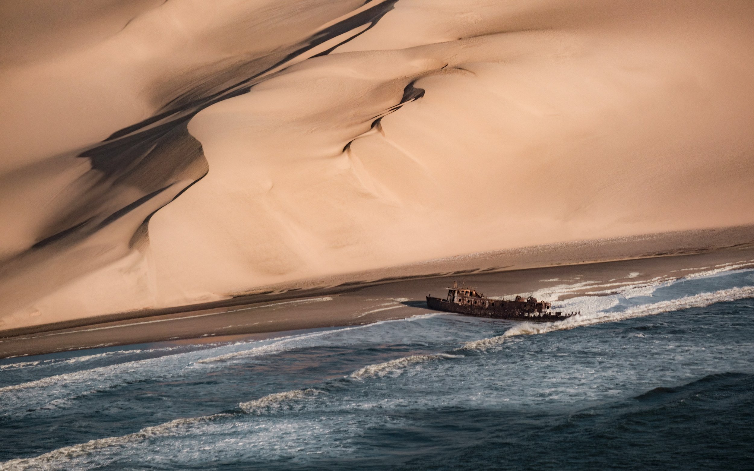
A ship wreckage by the red, sandy dunes along the Skeleton Coast. op23 | Unsplash

A map highlighting the Namib Desert in red along the coast of Africa.
Home to earthy-red dunes which roll right into the Atlantic ocean, the Namib Desert is thought to be between 50-80 millions years old, making it the oldest desert in the world. It’s also one of the world's most inhospitable places—an unpredictable, arid and remote region that on the surface has no appeal whatsoever. With temperatures fluctuating from blistering hot to dangerously cold and sand for as far as the eye can see, it extends from the country of Angola, through Namibia and down to South Africa. That’s over 31 thousand square miles of desert.
But don't be fooled, there’s more to these sandy plains than meets the eye. The Namib is home to the Skeleton Coast. And despite this desert’s penchant for death, The Skeleton Coast is teeming with rare wildlife.
What is the Skeleton Coast
The Skeleton Coast is on the northern shores of this ancient and unexpected desert and earned its macabre name from the whale and seal bones that once littered the shore from the whaling industry. The Ovahimba who have since settled in the far north-eastern parts of Namibia once used the whale bones for building their shelters. In modern times, the Skeleton Coast hides its infamous graveyard buried beneath the sand, and with the exception of a rare adventure seeker looking for a wave to surf, the odds of seeking a human along this part of the coast are slim.
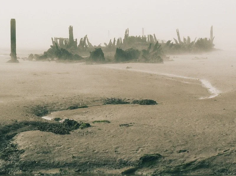
A shipwreck in the fog on the Skeleton Coast. Lee | CC BY 2.0
The Unique Climate of the Namib Desert
The bones scattered across Namibia’s Skeleton Coast aren’t from ocean mammals alone. Over the centuries, ships have ended up stranded on its shores for various reasons, but the main culprit is caused by the unique geography of the region. Hot, dry air from the interior of the continent and desert blows west combining with the cold wet air from Antarctica via a northward flowing ocean current called the Benguela Current. The hot dry winds act as a cap or roof not only prevents the cold wet air from escaping, but also from forming rain clouds. Instead, there is an eerie fog, and a lot of it.
In fact, for 180 days of the year there is fog on the Skeleton Coast so dense, it’s caused thousands upon thousands of ships to run aground throughout history; the oldest of which is from the 1500’s. The ocean's intense surf would have prevented anyone from getting back into the water, and with a wrecked ship, this meant that sailors stranded on this isolated coast were left with only one choice: to make their way through the Namib Desert. With a dryness rivaling South America’s Atacama Desert (the driest place on Earth), and sand dunes reaching nearly 1000 ft high, this option was nearly as dangerous as swimming out to sea and surely has added human bones to its burial collection.
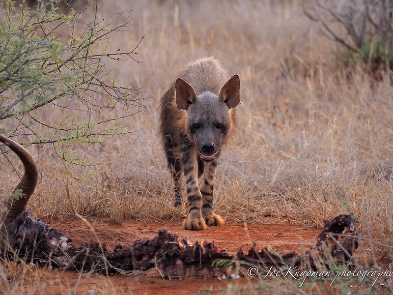
A brown hyena stands over a carcass in the Namib Desert. Joe Knapman | CC BY 2.0
Wildlife on the Skeleton Coast
Incredibly diverse, the Skeleton Coast has more near-endemic species than any other desert in the world. Elephants, black rhinos, desert lions, jackals, giraffes, seals, oryx, kudus and zebras and just some of the desert adapted species inhabiting this wilderness. One such animal is the brown hyaena. They’re usually on the move after darkness has fallen, which adds to their elusiveness. The name strandwolf was coined on Namibia’s Skeleton Coast where they scavenge for dead seals along the shoreline. If you are fortunate enough to spot one, make sure you take a really good look, because sightings of these inscrutable carnivores is never guaranteed. A truly endemic avian, the Dune Lark, inhabits thinly vegetated dunes along the Skeleton Coast and larger Namibian dune system associated with Bushman grasses and Nara melons.

A blooming welwitschias. Ragnhild&Neil Crawford |CC BY 2.0
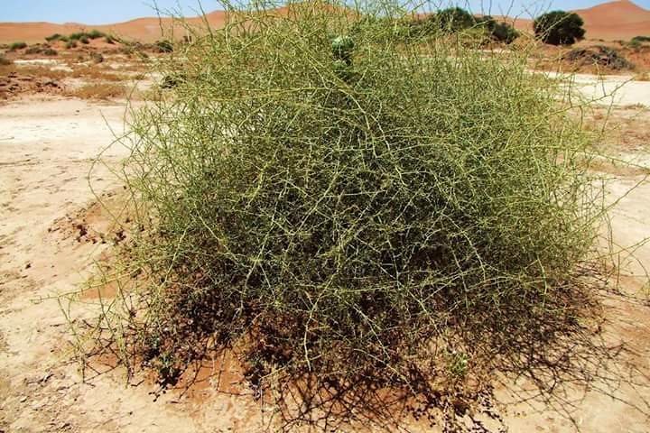
A spiny looking nara bush in the Namib Desert. Palmora| CC BY 2.0
Nara Melons are just one of the many plants incredibly adapted to the rainless area and depend solely on the warning fog from the Atlantic Ocean. The nara bush is of great importance not only to the people of the region, but it is ecologically key to maintaining the unique desert habitat. More plants include welwitschias—which is a dwarf tree with only two leaves that can live for several thousand years—several lithops succulent plants known as living stones, lichen, pencil bush and the vividly colored succulents of rainbow colored agate mountains dotting the shore.
The Lion’s Roar, a desert phenomenon
The phenomena of the Skeleton Coast doesn’t stop at bones, fog and compelling flora and fauna. Travelers, nomads and lost sailors once believed in the presence of desert spirits—singing songs through the mist. When the dunes form a bowl with the right acoustic properties, even a small flow of disturbed sand causes a terrific noise that resembles rolling thunder or even a low-flying airplane. The phenomenon is known locally on the Skeleton Coast as ‘the lion’s roar’.
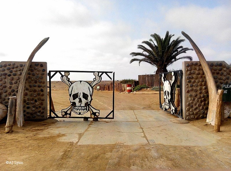
Ugab River Gate, Agnieszka Rysio | CC BY 2.0
The Skeleton Coast National Park
Luckily, this wildly unique, albeit creepy shoreline, along with its diverse inhabitants is protected. In 1971, Namibia established a well-maintained national park to protect the curious treasures, bones and wildlife which makes the Skeleton Coast so incredible. The park is divided into a northern and southern section; the southern section is open to travelers with four wheel drive vehicles who are welcomed to go as far north as the Ugab River Gate. There, they will be greeted by a sign with a skull and crossbones warning you to go no further. The northern section is off limits, its loose, enveloping sands will literally swallow you up and can therefore only be accessed by airplane with a certified guide. It also happens to be the most attractive region of the park with lunar-esque vistas as far as the eye can see. The park attracts all types of travelers, both local and international fishers, photographers, ecologists and folks just looking for a unique adventure to one of the world's most understated treasures.

Raeann Mason
Raeann is the Content and Community Manager at CATALYST, an avid traveler, digital storyteller and guide writer. She studied Mass Communication & Media at the Walter Cronkite School of Journalism where she found her passion for a/effective journalism and cultural exchange. An advocate of international solidarity and people's liberation, Raeann works to reshape the culture of travel and hospitality to be ethically sound and sustainable.
10 National Parks to Visit Outside the US
While most people associate National Parks with the US, there are amazing National Parks to visit around the world. Check out glaciers, tropical wetlands, the oldest desert in the world in these parks in Iceland, Namibia, Thailand, India and more.
Read More
The Delta’s rich array of wildlife makes it a popular tourist destination. Ger Metselaar/Shutterstock
Botswana’s Okavango Delta is Created By a Delicate Balance, But For How Much Longer?
The Okavango Delta in northern Botswana is a mosaic of water paths, floodplains and arid islands. The delta sits in the Okavango river basin, which spans three African countries: Angola, Namibia and Botswana.
Because it’s an oasis, in a semi-arid area, it hosts a rich array of plants and attracts a huge variety of wildlife.
As a unique ecosystem, in 2014 it was placed on UNESCO’s World Heritage list and it is an iconic tourist destination, which generates 13% of Botswana’s GDP.

Aerial view of the Okavango Delta. Vadim Petrakov/Shutterstock
But it’s a fragile natural area. It’s controlled by deformations of the Earth’s crust over a long time (thousands to millions of years) and by annual water flows and evaporation. The size of the flooded delta from year to year varies between 3,500km² and 9,000km² because of weather fluctuations which control its water supply.
Any change to the processes that form the delta will have an impact on the wildlife and local economic activities. Its grassy floodplains are food for grazing animals in the dry period. Losses of this habitat will cause declines in wildlife and livestock. It’s therefore imperative to understand what creates and sustains the delta for the future management of the system.
We have conducted several studies that cover how the Okavango basin was formed and the way dissolved chemicals are withdrawn from the delta’s surface.
The dynamic history of the Okavango Delta’s waterways and floodplains tells us that the interplay between geology, water and plants makes the delta resilient, but vulnerable.
Some imminent changes are expected that are of concern. One is higher temperatures, which will boost evaporation and transpiration. Another is the pumping of water for irrigation in Namibia. Both of these changes will reduce the water needed to sustain the delta’s floodplains.
An oasis
The Okavango Delta is a generally flat area which is under constant change with phases of flooding and drying. A variety of geographical and natural processes have formed it and sustain it.
It’s in a depression which was created by fault lines cutting the Earth’s surface. This means water flows into it. The fault lines are created by the spread of the East African Rift – a major fracture, created over millions of years, which crosses the eastern part of Africa.
The origin of the islands in the delta is attributed to two mechanisms: the construction of termite mound spires; and formation of elevated ridges where former channels deposited sand. Both act as the starting point for vegetation to take root.
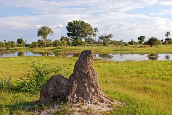
Termite mound in the delta. PIXEL to the PEOPLE/Shutterstock
The water supply comes from the Cubango and Cuito rivers in Angola. This reaches the delta between March and June and peaks in July. There’s also local rainfall in the Okavango area from November to February (about 450mm a year) which adds to this.
About 98% of the water that goes into the delta is eventually lost through evaporation and plant transpiration, when water moves through the plant and evaporates from leaves, stems and flowers.
Even though the subtropical sun generates intense evaporation, the delta’s water is fresh, not salty. This is surprising because water samples from the middle parts of the islands have very high chemical and salt concentrations. This chemical concentration occurs in thousands of islands.
The reason the water is fresh is that trees on the edges of the islands have created a barrier of natural filters between the inner part of the islands and the floodplain.
Possible changes
The Okavango Delta is continually being shaped by complex interactions of natural processes. If something happens to change the balance of these processes, it could destabilise the system.
The most important dynamic for the delta is inflowing water. The two main rivers in Angola, the Cubango and the Cuito, join to form the Okavango river, which feeds the delta. These two rivers are hydrologically quite different. The Cubango, to the west, first flows rapidly down steep, narrow paths characterised by incised valleys, rapids, waterfalls and valley swamps. The Cuito, to the east, with shallow valleys and large floodplains, gets its water from groundwater seepage.
The manipulation of these rivers – in the form of dams and irrigation – will affect the water flow and change its annual distribution. Both of these form part of current and future development planning in Angola and Namibia.
A decrease in water supply will affect the vegetation growth and the wildlife. An increase in water would inundate the islands and could dissolve the salts at the centre of them, releasing chemical elements that would change the water quality.
In addition to declines in water flow induced by global warming and human activities, ground deformation is also happening because of shifting continental plates. This could change the paths of the water flowing by changing the ground slopes. Measurements of ground deformation with Global Positioning Systems displays reveal very slight changes in local slopes that can modify the paths of the water flowing to the delta.
To sustain the Okavango Delta it’s imperative that management integrate all the components of the system. All governments are involved and must integrate scientific expertise, from upstream catchment to downstream Delta.
Michael Murray-Hudson is a Senior Research Fellow, Okavango Research Institute, University of Botswana
Olivier Dauteuil is a Directeur de Recherche au CNRS, Université Rennes 1
THIS ARTICLE WAS ORIGINALLY PUBLISHED ON THE CONVERSATION
NAMIBIA: Colors of a Country
Namibia is a land of contrasts and extremes. Situated between the Namib and the Kalahari deserts, Namibia gets less rain than any other country in sub-Saharan Africa. Namibia’s coastal desert is one of the planet’s oldest, with powerful offshore winds sculpting the highest sand dunes in the world, in some places rising more than 1,000 feet.
Water — or more to the point, its absence — defines life in Namibia.

Hot and arid in the interior, Namibia’s coast is surprisingly cool and moist, the product of the cold Atlantic colliding with Africa’s warm and dry southern tip. Seals and sea birds come by the thousands to congregate in this narrow temperate zone.


In the rest of the country, only where there is water is there life. Here is my vision of this untouched and primal land, with its towering red sand dunes, vast deserts, and wild animals struggling to survive.

KOLMANSKOP
Kolmanskop is a deserted German mining settlement located in Namibia. The town was abandoned in the 1950s, and the desert has been reclaiming it ever since, creating an interesting mix of colorful painted walls and sweeping sand dunes engulfing entire rooms.


QUIVER TREE FOREST
The Quiver Tree Forest, near Keetmanshoop, contains a collection of the so-called “quiver trees” which aren’t really trees at all, but rather a species of aloe, a flowering succulent plant.

NAMIB-NAUKLUFT NATIONAL PARK
Namib-Naukluft National Park preserves part of the extensive Namib Desert. The most famous area of the park is called Sossusvlei, which contains the tallest sand dunes in the world, rising more than 1,000 feet above the desert floor. Oxidization of iron in the sand gives them a reddish-orange color, which becomes especially intense when bathed in the warm light of sunrise and sunset.

One of the most stunning places in Sossusvlei is known as Deadvlei (which means “dead marsh”). The area used to be wet and covered in trees, but 600 or 700 years ago the water dried and the trees died, their eerie skeletons preserved by the dry air.

ETOSHA NATIONAL PARK
Etosha National Park is a beautiful national park in northwestern Namibia, known for its abundance of large game animals, including elephant, lion, rhino, giraffe, cheetah, zebra, and many more. What amazes me most about Etosha is the clear, strong light at sunrise and sunset, bathing animals and landscapes in warm color.


IAN PLANT
World-renowned professional photographer, writer, and adventurer Ian Plant is a frequent contributor to and blogger for Outdoor Photographer Magazine, a Contributing Editor to Popular Photography Magazine, a monthly columnist for Landscape Photography Magazine, and a Tamron Image Master. Ian is also the author of numerous books and instructional videos. See more of his work at www.ianplant.com