10 of the World’s Best Ecotourism Destinations

Ecotourism aims to preserve the environment while allowing travelers to get a glimpse of the natural world. These 10 destinations are sustainable travel options that will broaden visitors’ understanding of the environment along with other cultures. 

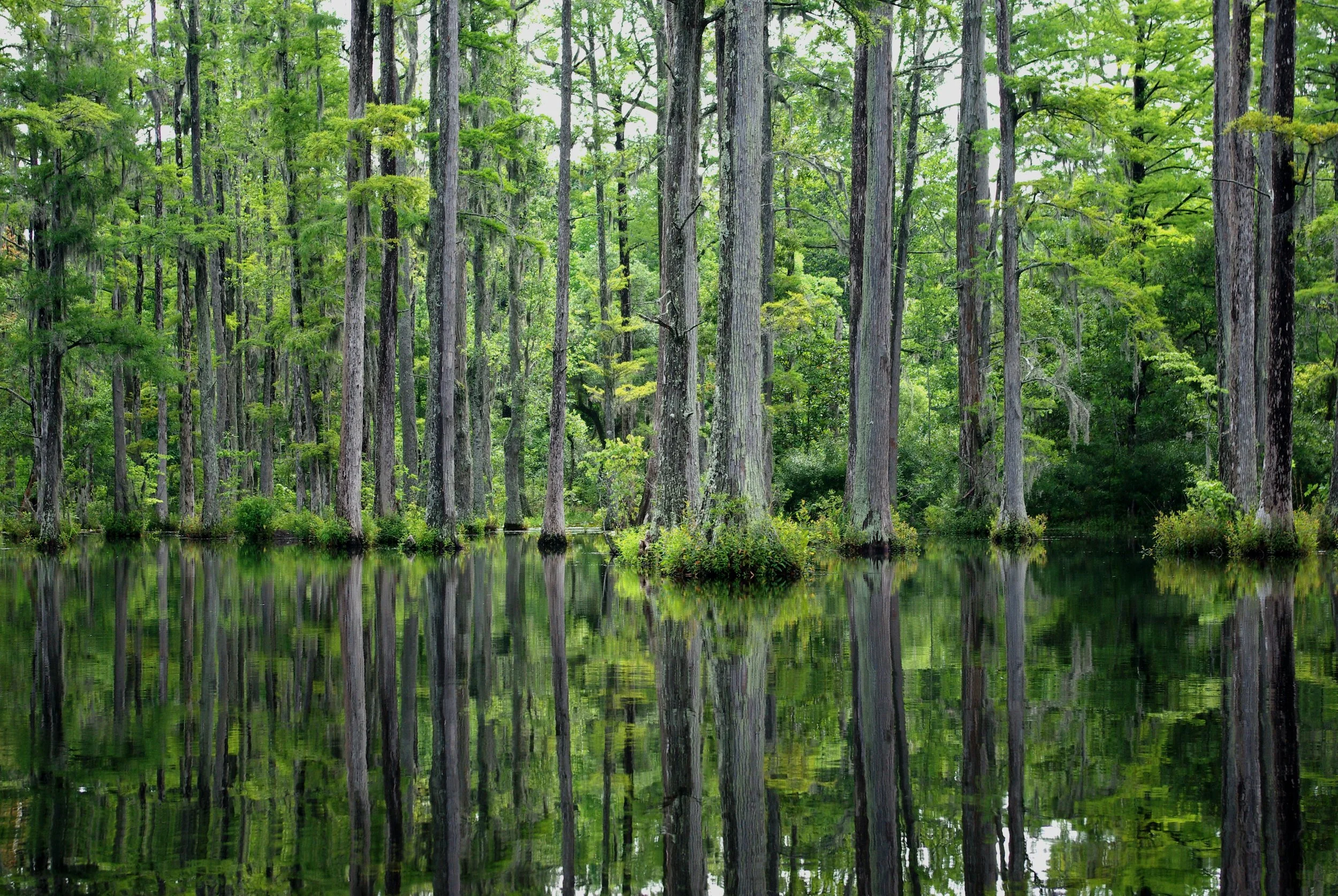
Sustainable tourism seeks to strike a balance between the environmental, cultural and economic impacts of tourism, and many destinations around the world are moving toward the model. Ecotourism is a subset of sustainable tourism that focuses specifically on the environment. The International Ecotourism Society defines ecotourism as “responsible travel to natural areas that conserves the environment, sustains the well-being of the local people, and involves interpretation and education.” Ecotourism is not just about seeing stunning parts of the natural world, but about trips that curate awareness of and respect for the global environment and cultures. These 10 destinations are sure to provide memorable travel experiences while heightening visitors’ understanding of the social, political and environmental climates of the places they’re exploring. 

1. Galapagos Islands, Ecuador

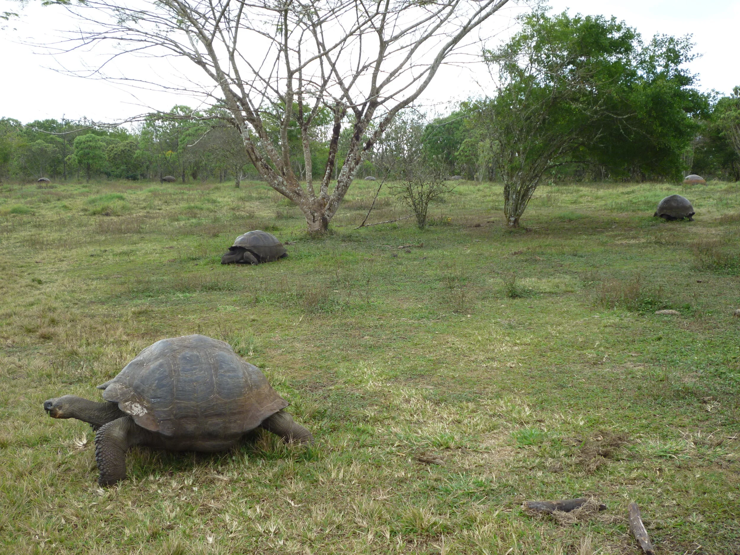
In 1978, the Galapagos Islands became one of the world’s first UNESCO World Heritage Sites, protected for their unusual plant and animal life that famously inspired Charles Darwin’s theory of evolution. The 19 islands, located about 600 miles off the coast of Ecuador, are home to giant tortoises, land iguanas and many subspecies of finches, as well as huge cactuses and trees unique to the islands. Ninety-seven percent of the islands have been part of a national park since 1959, and human settlement, including tourism infrastructure, is restricted to the remaining 3%. The islands are a paradise of natural beauty, and over 150,000 travelers visit annually. The Galapagos National Park Directorate and the Ecuadorian Ministry of Tourism have implemented regulations that ensure visitors get to explore the islands without harming the environment. The entrance fee that visitors pay for the national park is used to fund conservation projects, the number of tourists at each site at a given time is limited and all travelers are required to have a guide with them as they admire the islands. These guides are trained to educate the visitors and protect the sites, and are often local people, which ensures that travel benefits the local economy. 

Social issues: A current issue faced by the local population is the islands’ limited health care system, which consists widely of small, understaffed clinics. Ecuador is preparing for a runoff election for the presidential race, which will take place on April 11. Young people and women are major voter blocs in the election, hoping for policies that will address Ecuador’s economic crisis, inequality and rise in violence toward women. 

2. Costa Rica

Over a quarter of Costa Rica’s land is protected from future development. Costa Rica boasts incredible biodiversity, with thousands of different plant and animal species. The journey toward ecotourism in Costa Rica began in 1963 with the establishment of the Cabo Blanco National Reserve. The establishment of national parks quickly followed, and today Costa Rica has 70 separate entities within its park system. Visitors to Costa Rica will see a variety of ecosystems including cloud forests, rainforests, wetlands and coastal marine areas, all bursting with breathtaking plant and animal life. Places to visit include Arenal Volcano National Park, Cano Island Biological Reserve, Monteverde Cloud Forest Reserve and Ballena Marine National Park, though these are only a few of Costa Rica’s many stunning natural destinations. Most of these protected areas limit the number of visitors inside at any given time in order to prevent damage to the environment. The Costa Rican Tourism Board has introduced the Certificate for Sustainable Tourism (CST), which rates businesses, such as tour operators and hotels, on a scale of 0 to 5 based on their environmental, social and economic involvement and impact. The CST system allows tourists to make informed decisions and ensure that their trip is a sustainable one. 

Social Issues: A 2020 report revealed that Costa Rica was facing political fragmentation, economic slowdown and increased inequality.  Costa Rica’s two major political parties, the National Liberation Party and the Social Christian Unity Party, both recently suffered splits, creating more competing parties. Economic growth has declined, leading to an increase in unemployment rates, and the COVID-19 pandemic has only worsened the situation. The drug trafficking issues that have faced other Central American countries like Honduras and El Salvador have crept into Costa Rica, spurring an increase in violent crimes. 

3. Sabah, Malaysia

Sandakan, in Malaysia’s Sabah state, is home to the Sukau Rainforest Lodge, a lodge designed to be as eco-friendly as possible while still offering guests a comfortable and memorable experience. The lodge opened in 1995 and was the first in the area built on ecotourism principles. It is known as an ecolodge, a lodge which embodies the principles of ecotourism: protection and conservation of nature, benefiting the local community and offering programs to educate travelers about the natural and cultural environments they are visiting. A few of Sukau’s eco-friendly practices include rainwater harvesting, which makes the lodge 100% self-reliant for water, no radio or television in the rooms to eliminate some noise pollution and let guests focus on nature, employing a staff made up of 90% Indigenous people, and contributing $16,400 annually to conservation projects in addition to conservation levies collected from guests. A full list of Sukau’s sustainable policies can be found here on the lodge’s website. The lodge rises on stilts over the bank of the Kinabatangan River in Borneo, immersed in nature. Visitors to the lodge will have ample opportunities to spot orangutans, pygmy elephants, proboscis monkeys and hornbills in their natural habitat. Sukau offers a number of tour packages to explore Borneo by land or boat and experience its unique landscapes. 

Social Issues: In 2020, Malaysia’s government, headed by Prime Minister Muhyiddin Yassin, cracked down on protests and critical speech, began regulating freedom of expression and started taking a harsh stance on refugees, saying that they have no status or rights within the country. 

4. Rwanda

Rwanda has enjoyed a major tourism boom in recent years, and the country has made a strong effort to promote ecotourism. Known as “the land of a thousand hills,” Rwanda is full of beautiful, green landscapes, bamboo forests, volcanoes and incredible animal life, such as the endangered mountain gorilla. A number of new ecolodges have been constructed and are helping to fund reforestation efforts for indigenous trees. Rwanda’s number one ecotourism attraction is Volcanoes National Park, which is home to the mountain gorilla population. The park protects the Virunga Mountains, a chain of dormant volcanoes in the far northwestern corner of the country. The park encompasses a wealth of ecosystems, including evergreen and bamboo forests, sprawling grasslands and swamps. Visitors to the park can purchase tracking permits that allow them to go on mountain gorilla safaris and surround themselves with these amazing animals. The proceeds from the tracking permits go to improving the community development of areas around the park. There are a number of other locations for sustainable wildlife safaris in Rwanda, like Nyungwe Forest National Park and Akagera National Park. Visitors seeking to immerse themselves in local culture should explore the Iby’Iwacu Cultural Village, a traditional Rwandan village located within Volcanoes National Park. Stays in the village can be booked through Gorilla Guardians, a nonprofit organization that aims to improve the lives of reformed poachers and communities around the park. Visitors must abide by a set of sustainable living guidelines as they receive guided tours of the community from locals, learn about the area’s history and experience traditional arts practices, in order to ensure that travel is beneficial to both the tourists and the local community. 

Social Issues: Rwanda was the site of mass genocide in 1994, when members of the Hutu ethnic majority murdered around 800,000 people, mostly members of the Tutsi minority. As of 2020, the masterminds of the Rwanda genocide were still being brought to justice in international courts. In 2018, Rwanda implemented major legislative reforms, including a revised penal code, a new code of criminal procedure, and counterterrorism legislation. The country still faces strong limits of freedom of expression, with critical speech resulting in incarceration and even enforced disappearances. 

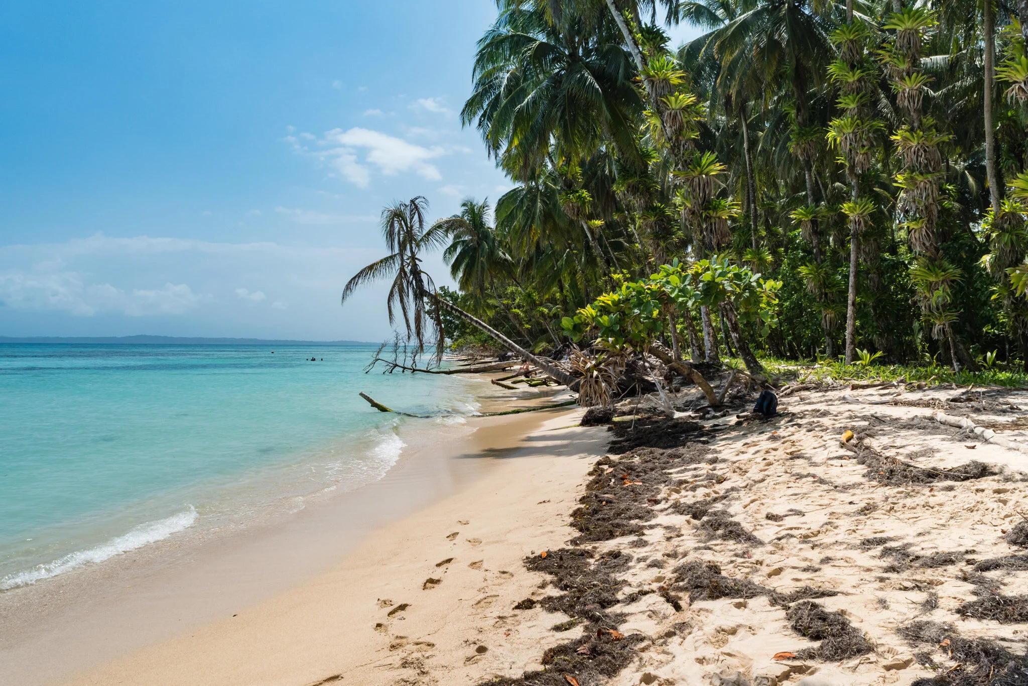
5. Bocas del Toro, Panama

Sometimes called the “Galapagos of the Caribbean,” Bocas del Toro, off the northern coast of Panama, is a haven of biological diversity and spectacular scenery. Made up of nine islands, the archipelago is home to Isla Bastimentos National Park, Panama’s first national marine park. Visitors to Bocas del Toro can zip line through the rainforest, scuba dive in tropical coral reefs, swim with manatees, learn to surf in the Caribbean and sail from island to island to see what each has to offer. Playa Larga on Isla Bastimentos is an annual nesting site for four endangered species of sea turtles. Isla Bastimentos National Park also protects diverse forests, 28 species of amphibians and reptiles, monkeys, sloths and crocodiles. Visitors can go on tours of the islands led by members of Bocas del Toro’s Indigenous tribe, known as the Ngobe-Bugle, to learn more about the area’s history and culture while admiring the plant and animal life. 

Social Issues: A significant issue in Panama is poverty. There is a large wealth gap between urban and rural areas; rural areas are less aided by economic booms and have worse access to good health care and education. Rural areas that are largely inhabited by the Indigenous population are especially impacted by this wealth gap, with 86% of Panama’s Indigenous population living in poverty. 

6. Sorsogon, Philippines

Located in Sorsogon province in the Philippines, Bulusan Volcano Natural Park is home to a wide range of natural features that make it a great destination for nature lovers. The park surrounds the active Bulusan Volcano and includes lush rainforest, two gorgeous lakes and two large mountain peaks. Visitors can kayak, hike, climb, see indigenous plants and animals, and visit local villages within the park. A number of local communities still flourish in the park, using the lower slopes of the mountains as agricultural lands. Many Indigenous people in the Bulusan Volcano Natural Park area have been trained as guides, allowing visitors to get a firsthand perspective of the park’s culture and environment and providing income for local communities. While in Sorsogon, visitors can also arrange to visit Donsol, where they can see whale sharks up close.

Social Issues: The government of the Philippines is still engaged in its violent “war on drugs,” which began in 2016. The campaign targets mainly impoverished Filipinos in urban areas, and killings by the police related to the “war on drugs” are rampant. Freedom of speech is limited, as those critical of the government face harassment and a number of journalists have been murdered in work-related attacks. 

7. Raja Ampat, Indonesia

The Raja Ampat archipelago, located just off the tip of Bird’s Head Peninsula in the West Papua province of Indonesia, consists of more than 1,500 islands. Raja Ampat is extremely remote, meaning it has remained in nearly pristine condition, with white sand beaches, sparkling blue waters, interesting caves and jungle-covered hills that make it known as one of the most beautiful archipelagos in the world. Raja Ampat is also a biological hot spot, rife with varied marine life. The area’s extensive coral reef makes it a major attraction for divers and other visitors who want to experience the natural majesty of the islands. As tourism began to rise in the formerly remote area, the government and nonprofit conservation organizations recognized the necessity of protecting the area’s incredible biodiversity and quickly implemented sustainable ecotourism policies. Numerous programs about Raja Ampat’s ecosystem were developed to educate visitors and locals alike about the need for conservation. The tourism industry is also mainly staffed by local islanders, allowing them to share their culture with visitors while advancing their livelihoods. Tourists can choose from a number of ecolodges to stay in and tour with, such as Papua Explorers. 

Social Issues: LGBTQ+ rights have long been under fire in Indonesia, used as a rallying cry and platform for conservative social and political groups. The rights to freedom of expression and peaceful assembly are limited, and human rights defenders are often criminalized. 

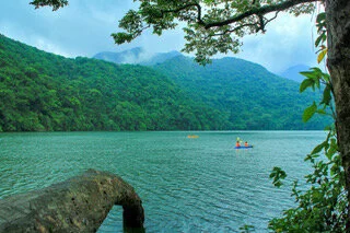
8. Mai Chau, Vietnam

In the Mai Chau Valley, located roughly 90 miles outside of Vietnam’s capital of Hanoi, traditional villages lie among rice paddy fields and border towering mountains. Mai Chau is full of functional communities and is a popular destination for visitors seeking to immerse themselves in local culture while surrounded by some of Vietnam’s most remarkable scenery. Mai Chau is home to multiple homestay villages, where visitors can stay overnight in stilt houses around Hieu village. Those staying in Mai Chau homestays will eat home-cooked meals and can explore the villages and purchase local crafts. The valley has no shortage of day hikes, and travelers can even rent bicycles to ride from village to village. Mai Chau is located near Hoa Binh Lake and the Pu Luong Nature Reserve, where visitors can see even more of the beautiful ecosystems Vietnam has to offer. Tourism in the Mai Chau Valley is sustainable because it educates visitors about the local culture and environment and stimulates the local economy while having very few negative impacts on the region. 

Social Issues: Vietnam has harsh restrictions on freedom of expression, peaceful assembly, association, movement and religion. Political detainees are often held for months without access to legal counsel, and the treatment they face in custody is often violent. Vietnam’s cybersecurity laws allow the government to block websites critical of the ruling party. 

9. St. John, U.S. Virgin Islands

In the Caribbean Sea, about 1,000 miles southeast of Florida, are the U.S. Virgin Islands. One of the islands in the group, St. John, is a pioneer of ecotourism. Two-thirds of St. John’s surface area and shoreline waters are set aside as the Virgin Islands National Park, making it the best preserved of the U.S. Virgin Islands. In the water surrounding the island are hundreds of coral gardens, which make up the Virgin Islands Coral Reef National Monument and are protected by strictly enforced laws to prevent damage to the coral. St. John has very little commercial development; the island has no airport, no large cruise dock and no high-rise buildings. The natural integrity of the island is nearly untouched, making it one of the best places in the world to get a real ecotourism experience. Visitors to St. John can explore the national park and learn about the area’s history, seeing petroglyphs carved by the Taino people and the sites of former sugar plantations. Visitors can also relax on pristine beaches, snorkel among the reefs, hike through historic ruins, and sail on crystal-clear waters. There are a number of eco-friendly resorts to choose from in St. John, many of which are campgrounds that offer tents and small cabins. 

Social Issues: The U.S. Virgin Islands are fairly dependent on tourism to support their economy. In 2017, two devastating hurricanes, Irma and Maria, hit the islands, inflicting extensive damage and leading to a decrease in revenue which the islands are still trying to recover from. 

10. Auroville, India

Auroville, in the Tamil Nadu state of India, is a very unique destination. Auroville is an experimental township that aims to be a “universal town,” where people of all backgrounds can live together in harmony with each other and with nature. Auroville was founded in 1968 by Mirra Alfassa, who is referred to as “The Mother,” and was designed by architect Roger Anger. The township runs on green practices, such as renewable energy, growing some of its own food through farming, recycling wastewater and working to protect the environment with a successful reforestation campaign. The township is financed partially by the government of India, which mostly gives money for education and projects, and partially by nongovernmental organizations, tourists and donors from around the world. Around half of the residents of Auroville are foreign, but they take care not to impose their culture on India, instead hoping to learn about the local culture. They also share their developments in farming with the villages around Auroville. 

Visitors to Auroville can book tours to experience life in the town, or stay for longer in one of Auroville’s guest houses. Those who come are strongly encouraged to acquaint themselves with the local culture of areas around Auroville to ensure that their visit is respectful. Auroville also runs a number of volunteer programs, where people from all over stay in the town and work on projects that include farming, animal care, education and renewable energy. 


Social Issues: In 2020, hundreds of people remained detained without charge in Jammu and Kashmir, under an Indian law that allows detention without trial for up to two years. Freedom of expression is limited, and journalists often face threats, criminal cases and even assault.


Rachel Lynch

Rachel is a student at Sarah Lawrence College in Bronxville, NY currently taking a semester off. She plans to study Writing and Child Development. Rachel loves to travel and is inspired by the places she’s been and everywhere she wants to go. She hopes to educate people on social justice issues and the history and culture of travel destinations through her writing.

The Movie Makes it: 6 Places Made Famous by Films

Many places in the world have been made iconic by films for their beauty and distinctiveness.

Movies have a unique ability to turn even the most seemingly mundane places into a magical new world. They uncover the hidden beauty of our planet, the secret wonders our world has to offer. Films - especially those that are popular - have an aptitude for making locations special in a way they weren’t before they were displayed on the big screen. The following 6 movies have iconicized their filming locations by displaying the beauty of our world and their fantastical essence.

1. The Notebook - Cypress Gardens, South Carolina

The Marsh at Cypress Gardens. Natalie K. CC BY-SA 3.0.

The infamous rainy boat scene from “The Notebook” was filmed in the Cypress Gardens in South Carolina. The main characters, played by Ryan Gosling and Rachel McAdams, are taking a romantic canoe ride through the marsh when suddenly rain starts to pour, causing them to quickly paddle to shore and seek refuge under the foliage together. 

Known as one of the greatest romantic films of all time, “The Notebook” has made Cypress Gardens a popular spot for those wishing to recreate the romance of the film. Those who visit the Gardens are able to take the same self-guided boat ride as Gosling and McAdams, cutting through water littered with gorgeous lily pads and surrounded by natural wildlife. 

 2. Jurassic Park - Kauai

Manawaiopuna Falls. Screaming_Monkey. CC BY-SA 2.0.

“Jurassic Park” is famous for the depiction of Kauai’s rolling valleys and tremendous waterfalls. Manawaiopuna Falls has become iconic after the scene it was featured in during “Jurassic Park.” When Laura Dern, Jeff Goldbloom and the rest of the star studded cast makes their way onto the island, they descend in a helicopter right besides Manawaiopuna Falls. This has made the waterfall an iconic place for fans of the film to come while visiting Hawaii, even giving the falls a nickname: Jurassic Falls. Helicopter tours are even available to fans who wish to experience the arrival scene.

3. Lord of the Rings - Matamata, New Zealand 

Hobbit homes. Curtis Simmons. CC BY-NC 2.0.

The Shire is a real place, and lucky for those who wish to see it, it is not endangered by any of the villainous creatures from the “Lord of the Rings” universe. Known as Hobbiton, the rolling hills of the Shire are incredibly popular for walking tours, as walking the land of Matamata feels like walking right into J.R.R. Tolkin’s stories. Looking exactly as they do in the films, Hobbiton is an incredible hub for tourism and exploration into a place seemingly unlike any other.

Hobbit holes - which are the houses built into the earth - are scattered across acres of lush grass. Many visitors like to take pictures in front of one of the many circular doors that come in a multitude of painted colors. 

4. Mamma Mia! - Skopelos, Greece

Skopelos beach. Titanas. CC BY-SA 2.0.

To accompany their incredible soundtrack, the team who produced “Mamma Mia” also gave us a stunning view of Skopelos, Greece. Crystal blue water, white sandy beaches and the Greek architecture of the city all make the set of “Mamma Mia” a place viewers dream of being. 

Though Merly Streep’s hotel from the movie doesn’t actually exist, the set of “Mamma Mia” is a combination of different locations around the island of Skopelos. Those who travel to the island can also find the set locations of iconic scenes in the movie, such as the Mamma Mia Cliff, where the wedding scene at the end was shot.

5. Forrest Gump - Marshall Point, Maine 

Marshall Point LightHouse. Me in ME. CC BY 2.0.

One of the most beloved moments in the award-winning film “Forrest Gump” is when Forrest runs across America. Starting in Alabama and going coast to coast, Forrest runs for “3 years, two months, 14 days and 16 hours”.  

During his long journey across America, Forrest finds himself running up the pier at Marshall Point, a scene that made the pier and accompanying lighthouse famous. Those who visit Marshall Point will find that the Lighthouse has a museum, with insider details on how “Forrest Gump” was shot and filmed there, alongside history of the Lighthouse and surrounding area. The view of the beaches of Maine, alongside the rocky shore, and long sea grass also make for a beautiful set.

“Forrest Gump” was also responsible for making Chippewa Square in Savannah Georgia an iconic landmark for the bench scenes, when Forrest tells his story while waiting for the bus.

6. Game of Thrones - Dubrovnik, Croatia 

Dubrovnik shoreline. Zlatko Unger. CC BY-NC-ND 2.0.

Though “Game of Thrones” is not  technically a movie, it is arguably the greatest television show of all time and contains some of the greatest visual imagery to ever see the screen. Though there are many stunning set locations “Game of Thrones” has iconicized to choose from, Dubrovnik, Croatia seems the most fitting for this list. Located on the coast of the Adriatic sea, Dubrovnik is the set on King’s Landing, the most infamous place in all of the “Game of Thrones” series.

With a wonderfully condensed city to explore, alongside a beautiful coast and rugged, mountainous landscapes, Dubrovnik is a great destination for travel even for those who are not fans of the show. However, the city has seen a significant increase in tourism since the airing of the show, and in the wake of its global popularity, Dubrobnik has now become one of the main filming locations visited from the show.


Ava Mamary

Ava is an undergraduate student at the University of Illinois, double majoring in English and Communications. At school, she Web Writes about music for a student-run radio station. She is also an avid backpacker, which is where her passion for travel and the outdoors comes from. She is very passionate about social justice issues, specifically those involving women’s rights, and is excited to write content about social action across the globe. 

The Largest Salt Flat in the World in Bolivia

Bolivia’s Salar de Uyuni is one of the country’s wonders. Despite the amount of tourists it still preserves its beauty.

Salar de Uyuni, Bolivia. Giacomo Buzzao. CC BY 2.0.

Located in the Andean Plateau in South America, the Salar de Uyuni is the largest salt flat in the world. It is in southwestern Bolivia, close to the border between Bolivia, Chile and north of the Argentinian border. It is over 4,050 square miles and the salt crust stretches to the horizon. It is also 10,000 feet above sea level, as it is located in the Andes. Since the salt is white, the Salar de Uyuni appears to be a large white desert, but during the rainy season, nearby lakes overflow, rivers empty into the salt flat and it becomes filled with water.

Though the seeing the dry, white salt stretch for miles is beautiful, when the salt flat is filled with water, it creates a clear mirror-like lake. Generally, there are only a few centimeters of water so it is still possible to walk on it, but as the weather is unpredictable, some areas become restricted for safety. The salt flat is mostly waterproof, but too much rain will melt some of the salt and make it dangerous to walk on. However, during this time, Salar de Uyuni turns into the world’s largest natural mirror, reflecting the light from the sky. The winter months also have clear skies that offer beautiful stargazing opportunities, the reflected stars only adding to the salt flat’s wonder.

The Salar de Uyuni is large enough to be seen from space, and it contains 10 billion tonnes of salt. 70% of the lithium in the world is also mined from this salt flat. The Salar de Uyuni was created 40,000 years ago, after Lake Michin evaporated. Over the course of its slow evaporation, the salt hardened and created a crust that formed the area into what it is today. In addition, there is still water underneath the salt that continues to evaporate as temperatures rise, which adds more salt to the surface. 

Beyond the scientific explanation for the Salar de Uyuni’s creation, the locals have passed on their own legends. In one of them, one of the nearby mountain goddesses, Yana Pollera, gave birth to a baby that two other mountain gods fought over. They both believed themselves to be the father, and Yana Pollera sent her child away to where the salt flat is located today and flooded the area with her milk that eventually evaporated into salt so it would survive. Another legend claims the flat was formed because after two mountain gods were married, the husband left and the wife cried until her tears created the Salar de Uyuni. 

Dawn at Salar de Uyuni. Trevor McKinnon CC BY-NC-SA 2.0.

Because of its location, there are many tours leaving from Bolivia and Chile, and many of them stretch over the course of multiple days in order to get the most out of the natural beauty. Planes, buses and trains are all able to get to Uyuni, the town closest to the salt flat, but there are also tours from Tupiza, a town south of Uyuni, and San Pedro de Atacama, a town in Chile.


Katherine Lim

Katherine Lim is an undergraduate student at Vassar College studying English literature and Italian. She loves both reading and writing, and she hopes to pursue both in the future. With a passion for travel and nature, she wants to experience more of the world and everything it has to offer.

The Ice Marathon: Racing Through The Antarctica

The Ice Marathon takes place in Antarctica, known to extreme athletes as the Southernmost Marathon in the world.

Ice Marathon finish line. Rosana Katinas. CC BY-SA-4.0.

The Ice Marathon is an event geared towards committed runners who seek to compete in extreme conditions that guarantee once-in-a-lifetime experiences. Held in Antarctica, the Arctic Ice Marathon is known as the southernmost marathon in the world and is scheduled this year to occur on December 13th, 2022. It also gains most of its notoriety for the conditions under which the run takes place; sub-zero temperatures, snow and ice-covered parts of the course, and  certainly the location that makes this race just as much of an adventure as it is a competition.

The race is said to take place in the area below the Ellsworth Mountains, which is the highest mountain range in the arctic and just “a few hundred miles from the South Pole”. Like any marathon, the Arctic Ice race is 26.2 miles long, and what makes this run so challenging is the climate and the terrain. The cold and the underfoot terrain, which is a term used to describe course conditions, create daunting obstacles for any participant competing.

Ellsworth Mountain range. Nasa Goddard Photo and Video. CC BY 2.0.

The first challenge that presents itself to participants is the cold. Antarctica’s temperature averages around 0 degrees celsius during the month of December, which is when the race takes place, but conditions have dropped to -25C in the past. Those who have previously participated in the Arctic Ice Marathon have been known to try and simulate the cold to prepare themselves for the climate by placing treadmills in freezers and running in the artificial cold.

Specific gear is also required. The Ice Marathon’s event website says that wind pants, a down jacket and insulated boats are absolutely necessary to compete in the event. Additional requirements for runners include wool socks, fleece pants and shirts, sunscreen and polarized sunglasses, along with a few more generally required items. 

The second most challenging part of the race is the underfoot terrain. The Ice Marathon website states “the course will be groomed beforehand so it should be reasonably solid, but [is] not always”. This means that though there will be no deep snow on the course, there may be slippery ice and spots where the snow is not as tightly packed, causing the terrain to be more “energy sapping”. Advice for any athlete training for the ice marathon is to practice on sand or any other irregular or uneven terrain.

The fee to enter the marathon is $19,500. This provides the runner with their choice of race – the Arctic Ice Marathon offers a half-marathon and a full one – flights, stays and meals to and from Antarctica, and additional merchandise and photographs of the experience. The entire travel and race experience is 6 days.

Designed to entice adventure-seeking athletes, the Arctic Ice Marathon course is a prerequisite to joining the 7 Continents Marathon Club, which athletes can join once they have run and completed a marathon in every continent in the world. With over 300 members, the 7 Continents Marathon Club is an amazing way to commemorate the hardwork and dedication of marathon runners.


Ava Mamary

Ava is an undergraduate student at the University of Illinois, double majoring in English and Communications. At school, she Web Writes about music for a student-run radio station. She is also an avid backpacker, which is where her passion for travel and the outdoors comes from. She is very passionate about social justice issues, specifically those involving women’s rights, and is excited to write content about social action across the globe. 

An Explorer’s Guide to Visiting Edinburgh

From hiking up a volcano to ancient stone castles, a travel writer discovers the natural beauty and rich history of the Scottish capital

A view of Edinburgh’s skyline from Calton Hill. Mike McBey. CC BY 2.0.

Named TimeOut magazine’s best city in the world in 2022, Edinburgh is the perfect destination for those looking to experience the natural beauty and history of Scotland. Before visiting for myself, I knew very little about the city past its prestigious university, but I soon discovered how much more the city has to offer than the Loch Ness tours and Fringe Festival performances that initially came to mind. Edinburgh is located on the southeast coast of Scotland, just a 10 minute drive away from the North Sea. An ancient volcano which last erupted around 340 million years ago is responsible for the many volcanic rock formations surrounding the capital, one of which is now home to the city’s Old Town district.

Victoria Street is said to have been the inspiration for Diagon Alley in J.K. Rowling’s Harry Potter book series. Ralf Steinberger. CC BY 2.0.

Bird’s eye view shots of Edinburgh are often marked by a scattering of towering gothic constructions, but exploring the labyrinth of the Old Town was at the top of my list. In order to protect and preserve its impressive display of traditional British reformation-era buildings and rambling cobblestone streets, Edinburgh’s Old Town became a UNESCO World Heritage site in 1995. It stands in contrast to the city’s New Town in the north, which was constructed entirely in the Georgian style between the 1760s and the 1830s. The Old Town’s beautiful spread of architecture houses museums, galleries, ancient churches and shops, with Victoria Street being a favorite of mine because of its historic stone arches and colorful storefronts.

Exploring the area by foot is a must — I discovered countless hidden alleyways tucked between shops that led to smaller churches and hidden cloisters that were built hundreds of years ago. Spreading throughout the district, countless pubs make it a favorite among those looking to get a taste of Scotland’s national drink: whisky. Those under the age of 18, however, can happily enjoy the unofficial national drink of Irn Bru, a non-alcoholic soft drink first brewed according to a secret recipe back in 1901.

Edinburgh Castle sits at the very top of Castle Hill and looks out over the city from the West. Kim Traynor. CC BY-SA 2.0.

Perched on a volcanic rock outcrop sits Edinburgh Castle, with its ancient stone towers and turrets looking down over the Old Town. Fortunately, I booked tickets ahead of time and got to pass the huge crowds at the entrance, and visiting around midday when most people are stopping for lunch also allowed for a much more private exploration of the castle grounds. Depending on the part in question, sections of the castle date back to the 12th century, with newer additions being constructed by various monarchs over the next few centuries. I was able to get up close and personal with the Scottish Crown Jewels, and witnessed the daily firing of a cannon at 1 pm before touring the National War Museum, all set against the backdrop of Edinburgh’s eclectic skyline and the shoreline in the distance.

Holyrood Palace sits at the end of the Royal Mile and is the official Scottish residence of the British Monarch. Adam Fagen. CC BY-NC-SA 2.0.

Edinburgh’s other royal residence sits at the base of the ancient volcano responsible for the city’s unique geography. Still in use by the royal family today, Holyrood Palace was originally built by King James IV in 1503 upon his marriage into the British Monarchy. Very little remains of the original buildings as subsequent royals amended and added to the palace during their reigns. While generally open to the public year round barring royal visits to the Scottish capital, I chose to enjoy the palace’s facade from its visitor’s cafe, where a beautiful view of the Scottish Parliament building across the road can be seen. A short walk to the palace’s rear brought me to the entrance to a large park, which used to be part of the palace grounds but is now available for public use as well.

A view of Edinburgh from the top of Arthur’s Seat. Euan Marley. CC BY-NC-ND 2.0.

Surrounding the palace is Holyrood Park, home to the rocky spires of the Salisbury Crags and Arthur’s Seat, the remains of a now-dormant volcano. I made sure to familiarize myself with the various hiking trails to the volcano’s summit as signage within the actual park was very limited. Some of these routes were specifically for those looking to visit with their bikes, while others allowed for a much more leisurely stroll through the park’s meadows. The park also has a rich history: en route to the top of the 251 meter tall (roughly 823 feet) mountain lies the ruins of a medieval chapel and agricultural terraces from the Bronze Age. I came upon these sites by accident as they are not located along the main routes but are still easily accessible. Reaching the summit took just over half an hour, and the incredible 360 degree views of Edinburgh, and the surrounding towns were well worth the climb. A word of warning: despite visiting on a relatively warm and sunny day in the middle of the summer, the winds at the summit were still incredibly strong and should not be underestimated!

The National Monument is located at the top of Calton Hill. Culture Map. CC BY-NC 2.0.

For those looking for picturesque views of Edinburgh’s skyline without an hour long hike, Calton Hill is a perfect alternative. Also known as “Edinburgh’s Acropolis”, the 10 minute walk along a paved road to the top was significantly easier than the climb up Arthur’s Seat. Once at the top, I discovered the Collective Gallery, a contemporary art center that cycles through exhibits by local Scottish artists, as well as a luxury boutique restaurant with stunning views of the city. Also on the hill are the National and Nelson Monuments, the former being dedicated to Scottish soldiers who perished in the Napoleonic Wars. The monument was intended to be an exact replica of the Parthenon down to the exact dimensions of each block of stone. Unfortunately, the monument was only half finished when work stopped in 1829 and was never completed, though the part that stands today still forms an impressive and iconic part of Edinburgh’s skyline.

Nelson’s Monument stands in front of the Edinburgh skyline as seen from the top of Calton Hill. Andrew Colin. CC BY 2.0.

More than anything, I was surprised by how well Edinburgh was able to marry its incredible history with modern luxuries and infrastructure. It is a city of contrasts tucked in between rocky volcanic hills and the vast North sea, with Michelin-starred restaurants housed in old Georgian townhouses, and traditional tartan sold alongside extravagant cashmere. You can just as easily enjoy a plate of traditional haggis in an ultra-modern gastropub as you can take in a Shakespeare play in the newly renovated King’s Theater Dome. My visit, while only 3 days long, was jam packed with experiences unique to Edinburgh’s distinctive geography, history and culture. There is truly something to interest everyone and more, if you are willing to go off the beaten track and venture down an intriguing cobblestone alleyway or two.


Tanaya Vohra

Tanaya is an undergraduate student pursuing a major in Public Health at the University of Chicago. She's lived in Asia, Europe and North America and wants to share her love of travel and exploring new cultures through her writing.

Jeju: South Korea’s Largest Island

Jeju-do, known as Jeju Island, is the largest island in South Korea, and is home to beautiful natural scenery and an interesting community of women divers known as haenyeo.

Jeju Island. Republic of Korea. CC BY-SA 2.0

South of the Republic of Korea lies Jeju Island, a volcanic island famous for its beautiful beaches, resorts and landscape. The volcano on the island is a shield volcano called Hallasan, and it is the largest mountain in South Korea, standing at 1950 meters tall. Its status is considered active, but there are some who disagree since the last time it erupted was in 1007 AD. Also, the volcano does not smoke, and there is no fire coming out, so it appears to be dormant, hence the disagreement. Jeju Island is both the largest and only island in South Korea that governs itself. It is home to the World Heritage Site Jeju Volcano Island and Lava Tubes, and it is one of the new 7 wonders of nature alongside areas like South America’s Amazon Rainforest, Indonesia’s Komodo Island, South Africa’s Table Mountain and others.

Beyond the volcano, the island also has a network of lava caves and tunnels. The beaches, too, are beautiful, and there are walking trails called Olle, which means “a winding path to your front door” in the local dialect. They cover almost the entire island, and along their route people can see the sea, rock formations, caves and more. There are interesting rock sculptures known as Dol Hareubang, which are statues carved from the volcanic rock all over the island. The name translates to “grandfather made of stone”, and they get this name because they all have elderly features. They are also considered to be guardians of the island that ward off evil spirits and demons.

Dol Hareubang. Charity Davenport. CC0 1.0

Beyond the natural beauty of the island and the stone statues, Jeju Island is home to a community of women, known as Haenyeo. They are all divers that gather food from the sea like oysters, sea urchins and abalone. The thing that makes them truly unique, however, is the fact that they don’t use oxygen masks. They free dive down to as deep as 30 feet below the surface and can hold their breath for minutes. Girls start learning how to swim, dive and help the women from as young as 8 years old, and there are women still diving who are in their 80s. The women have been the ones to do this for many years, in part because there were a lot more of them than men on the island. The Korean War also caused an increase in women being more economically engaged. 

Haenyeo are considered to be the first working mothers of South Korea and have made diving their profession. There are no men participating in the dives and harvesting of seafood. Like many places, South Korean society has been typically male dominated, so the women on Jeju Island are very different. They have been diving for the past 1700 years, but after an increase in the demand for seafood the haenyeo were doing well and they started  trying to provide better education and other career options. As a result, many women choose  to not follow the diver tradition and the number of haenyeo has decreased since then. A lot of them are also older women who have been doing it for their entire lives, while the younger and middle-aged women chose to follow career paths. The women’s work and contributions have led to them being mentioned in UNESCO’s list of Korea’s cultural heritage in 2016.


Katherine Lim

Katherine is an undergraduate student at Vassar College studying English literature and Italian. She loves both reading and writing, and she hopes to pursue both in the future. With a passion for travel and nature, she wants to experience more of the world and everything it has to offer.

7 Breathtaking Waterfalls Around The World

From the tropical jungles of the Philippines to the glacial mountains of Iceland, these seven waterfalls are some of the most beautiful out there.

The Cascadas de Agua Azul, located in southern Mexico, are a series of waterfalls on the Xanil River. Claudia Tavani. CC BY-NC 2.0.

Every year, countless travelers visit the world’s tallest waterfalls, with Niagara Falls receiving over 13 million visitors alone. However, it is only one of hundreds of waterfalls in North America, and one of thousands worldwide. Hidden away in corners of South America, Europe, Africa and Asia are a multitude of other falls that display nature’s power and beauty. Waterfalls are divided into ten categories depending on their geographic surroundings and how they descend through them.  These include punchbowl waterfalls like the Kawasan Falls at number three on our list, horsetail waterfalls, chutes, cataracts, cascades like the one found at Akchour at number seven on our list and block waterfalls formed by wide rivers falling in uninterrupted sheets, to name a few. Here are seven incredible highlights that may not be the tallest or widest in the world, but are absolutely unmissable simply for their sheer beauty.

1. Plitvice Waterfalls, Croatia

Croatia’s Plitvicka Jezera National Park is home to a beautiful network of lakes and waterfalls. Jack Brauer. CC BY-SA 2.0.

Located in central Croatia between the country’s capital of Zagreb and the coastal city of Zadar, Plitvice Lakes National Park has been a UNESCO World Heritage site since 1979. Its protected area spans 300 square kilometers (roughly 115 square miles) and comprises a network of lakes and caves, which are connected by a series of breathtaking waterfalls. These can be viewed from the various footpaths and wooden bridges that traverse the park, or visitors can also enjoy a boat ride included in the price of the entrance ticket. Because of its protected status, the park is also home to bears, wolves and eagles among a whole host of wild animals.

2. Iguazu Falls, Argentinian-Brazilian Border

A birds eye view of one of the many waterfalls in Iguazu National Park, Argentina. Tomfriedel. CC BY 2.0.

The Iguazu Falls stretch for 2.7 kilometers (around 1.7 miles) along the border between the Misiones province in Western Argentina and the state of Paraná in Eastern Brazil. Altogether, the network makes up the largest system of waterfalls in the world, and was accordingly named a UNESCO World Heritage site in 1984. Thanks to a longstanding preservation effort in the two national parks on either side of the border that share custody of the falls, a network of walkways and viewing platforms can bring visitors very close to the falls, including near the bottom in an area called “Devil’s Throat”. You can travel to the falls by car from both the Brazilian and Argentinian sides, as well as from the Ciudad del Este in Paraguay. 

3. Kawasan Falls, Cebu Island, Philippines

Kawasan Falls is hidden away in the jungles of Cebu Island, Philippines. Vicky Flip Flop. CC BY-NC-ND 2.0.

The Instagram famous turquoise waters of Kawasan Falls are reachable by a three-hour bus ride southwest of Cebu City in the Philippines. The tropical waterfall is accompanied by limestone canyons and a dense jungle, all of which surround the pools often referred to as the “Gatorade Factory” due to their incredible color. Located in the coastal municipality of Badian, visitors can hike the kilometer and a half (just under a mile) long route uphill to reach the first and largest of many waterfalls that make up the series. Those interested in spending more time in the area can even book cottages available for overnight stays, though most opt to simply rent bamboo rafts to explore the pools.

 4. Gullfoss, Iceland

Iceland is home to numerous waterfalls with the Gullfoss Waterfall being a favorite among locals. O Palsson. CC BY 2.0.

The Icelandic name Gullfoss translates into “golden falls” in English, a reference to the sediment in the Hvita River from the nearby glacier that causes this spectacular waterfall to glow gold in the Nordic sunlight. Located a 90-minute drive west of the capital of Reykjavik, the two cascades that form Gullfoss are not actually that tall, falling for a total of only 31 meters (roughly 102 feet). However, seeing the waterfall up close can still be a deafening experience with floods of water going over the edge at a rate of around 109 cubic meters (just under 50,000 cubic feet) per second. There aren’t any railings or barriers either, so it is up to visitors to keep a safe distance from the cliff’s edge.

5. Weeping Wall, Hawai’i, USA

Travelers can visit Hawai’i’s Weeping Wall located in the heart of Kauai Island. Ahonui Bowman. CC BY-NC-ND 2.0.

Hawai’i is well-known for its incredible natural beauty, and the Weeping Wall is one of many spectacular sites on the island of Kauai. The network consists of a series of extremely narrow waterfalls winding across the centrally located Mount Waialeale, which stands 1,569 meters (about 5,066 feet) tall. The mountain’s name translates from Hawaiian to “overflowing water”, given that this location is in fact the second wettest area on the planet, and receives just under 11.5 meters (just under 37.5 feet) of rain every year. Given the mountain’s height, visitors rarely get a view of the upper part of the falls as it is often hidden in the clouds, but watching the water tumble down through the tropical greenery is still an incredible sight to see.

6. Ban Gioc Waterfall, Vietnam

A view of the Ban Gioc Waterfalls from Cao Bang, Vietnam. Applejuice. CC BY-SA 2.0.

Located on the border between the Cao Bang province in Northern Vietnam and the Guang Xi province in Western China, the Ban Gioc falls are the largest waterfall network in Asia. The waterfall stretches over 30 (about 98 feet) across on the Chinese side where it is known to locals as the De Tian Waterfall instead. Ban Gioc cascades down over three tiers of lush greenery, feeding directly into the Quay Son River, which in fact runs along the China-Vietnam border. Traveling to the falls from the Vietnamese capital of Hanoi normally takes visitors about two days to complete, with an overnight stop in Cao Bang City to split up the six and a half hour drive. 

7. Cascades D’akchour, Morocco

The higher of the two waterfalls that make up Cascades D’akchour near Chefchaouen, Morocco. Culture Trekking. CC BY-ND 2.0.

The Cascades D’akchour are tucked in amongst the Rif Mountains, the northernmost chain in Morocco. Reachable via a 45-minute drive from the famed “blue city” of Chefchaouen, visitors can enjoy a mountainous trek connecting several smaller waterfalls before arriving at the final cascade whose upper section tumbles down 100 meters of rock face (roughly 328 feet) into a collecting pool. The lower cascade, on the other hand, stands at a much smaller 20 meters tall (just under 66 feet) but also features a natural swimming pool just upstream of its descent over the cliff. For those interested in exploring even further, another hour and a half of hiking can bring you to the Pont de Dieu or Bridge of God, a naturally formed rock bridge carved out of the mountain by the Farda River.


Tanaya Vohra

Tanaya is an undergraduate student pursuing a major in Public Health at the University of Chicago. She's lived in Asia, Europe and North America and wants to share her love of travel and exploring new cultures through her writing.

All-Woman Rowing Team Takes On The Great Pacific Race

Four women compete in the Great Pacific Race, rowing from San Francisco to Hawaii.

For those who row competitively, completing the Great Pacific Race (GPR) is the pinnacle of a successful career. The race – which is a total of 2,080 miles (3,328 meters) – starts in San Francisco and ends in Hawaii. Teams of 3 or 4 are able to enter and are challenged to make it to Hawaii in as little time as possible. Though completely alone in their rowing efforts, every team is monitored from afar during all hours of the day by GPR crew in the instance of any emergencies.

Latitude 35, an all-female rowing team vetted with years of ocean rowing experience, has decided to challenge themselves in completing the Great Pacific Race. Among them are Adrienne Smith, Libby Castello, Sophia Denison-Johnson and Brooke Downes. They are not the first all-women’s team to compete, but they may be the fastest to ever finish the race if they maintain their pace on the last leg of their journey. The previous record that Latitude 35 wishes to crush is set by the Ocean Sheroes, who took on the challenge in 2021 and completed it in a little over 35 days. 

The first Great Pacific Race occured in 2014, and the organizers have held four subsequent “campaigns” since, with a total of 19 teams to ever complete the journey. Usually four or five teams will compete in the same race at a time, traveling from all over the globe to test their strength and willpower. Within the five sets of races that have taken place over the years, itvNews reports only “two four-person all female teams” have finished the race, making Latitude 35’s journey all the more special. 

Additionally, competitors are racing against the clock, not necessarily each other. To “win” the race, teams have to complete the journey the fastest, so the women of Latitude 35 are technically competing against teams – specifically the Ocean Sheroes – from a year ago who hold the current time record. Men and women may compete during the same campaign, but the race time records are separated by gender. However, it is important to note that just completing the challenge is a victory in itself; holding the world record for fastest time is just an additional win. 

Having left on June 21st, the Latitude 35 women have just about 495 miles (792 kilometers) left in their journey, and have done around 1590 miles (2,544 kilometers) in just over 28 days. They are on track to beat the pre-existing time record.

Besides the competitive nature of the race, it is also an incredible immersive experience with nature. Traveling on the open ocean for days allows participants to become up-close and personal with the ocean and all of its wonders. The Great Pacific Race describes the experience: “You will see shooting stars and the most incredible skies. You will experience nature in a way that few people can even imagine.” Latitude 35 has described their experiences with wildlife, including flying fish that have hopped around and into their boat.

The team has faced a few challenges along the way, including Tropical Estelle and Hurricane Darby, which threatened to hit the women’s route while they were on the open waters. Fortunately, neither the tropical storm nor the hurricane has found its way to the team, and the women are still safely continuing on.

The Great Pacific Race is a challenge of extraordinary athletic and physical strength. Calloused and blistered hands, sunburnt skin, hunger and fatigue all challenge the rowers. It is also a true test of emotional stamina and friendship. There is no reprieve from the rowing and physicality of the sport, just as there is no reprieve from your teammates. Latitude 35 has taken to Instagram to pass the time, and as they speak of their journey and the hardships they face – like rowing at night when all you want to do is sleep – they have gained a large following. 

Posting regular updates lets followers know where they are in their journey, as well as how they pass the time. Singing, laughing and making funny videos has helped the women stay motivated to finish their race. Additionally, Latitude 35 has started collecting donations for the Anxiety and Depression Association of America, raising money and awareness of the organization and what it has to offer athletes and those suffering with mental illness.


Ava Mamary

Ava is an undergraduate student at the University of Illinois, double majoring in English and Communications. At school, she Web Writes about music for a student-run radio station. She is also an avid backpacker, which is where her passion for travel and the outdoors comes from. She is very passionate about social justice issues, specifically those involving women’s rights, and is excited to write content about social action across the globe. 

Rising Travel Fees in Bhutan

After two years of being closed off to visitors due to COVID-19, Bhutan is re-opening to tourism, but with an increased tourism fee.

Children and pigeons in Thimphu. Xiaojun Deng. CC BY 2.0

Bhutan is a beautiful Buddhist country located in Southeast Asia. It is located along the eastern edge of the Himalayas, and there is plenty of mountain and valley scenery, as well as Buddhist monasteries. There are a multitude of reasons to visit Bhutan, but there is one interesting reason that might stop some people from going: the “High Value, Low Impact” tourism fee. 

In the past, the government of Bhutan has charged the equivalent of $65 USD per night per traveler. This has been a system implemented for three decades, but after COVID-19 and the decrease in tourism everywhere, the Tourism Council of Bhutan will raise the fee to $200 during the low travel season when the country reopens on September 23, 2022. During high season, the fee will be $250 per day for every person. India, Bangladesh and Maldives have been exempt from the tourism fee thus far, but when the country reopens, the government has decided to charge visitors from these three nations $17, with a few exceptions for certain age groups. Bhutan has been closed to outsiders for the past few years due to strict COVID-19 guidelines. The money gained from the travel fee increase will be used to decrease the carbon footprint created by tourists visiting the country, as well as to help the Bhutanese who work in the tourism industry. Even with the fee, tourism in Bhutan does make up 6% of the country’s GDP. 

Keeping Bhutan’s rivers clean. United Nations Photo. CC BY-NC-ND 2.0

There is a misconception that the $200 is an extra expense in addition to the usual travel costs, but that is incorrect. These fees are actually all inclusive, meaning it covers the cost of typical travel expenses, such as food, accommodations (though choosing to stay at luxurious hotel will cost extra), tour guides, transportations and tourist site entrance fees. Souvenirs, tour guide tips and drinks are the most common travel expenses that are excluded from the tourism tax. Those people have to pay for themselves.

A large question about the existence of the travel fee is where the money goes. Part of it, of course, goes to the government (around 30%), but the rest does go to the tour guides, hotels, drivers and other staff mem bers in the tourism industry. The government also does work to improve education, infrastructure and healthcare systems for its citizens, so the money tourists pay does go to improving the country. Furthermore, whether flying or driving into Bhutan, carbon emissions are being produced, and the tour buses and other modes of transportation add to it. Offsetting people’s carbon footprint from all that is an area the government is devoted to. The promotion of carbon-neutral traveling and making the tourism industry more sustainable overall are what Bhutan is committed to achieveing  in order to improve the country.

Bhutan is not the only country with a tourism fee. There are other countries that have implemented it as a way to combat over tourism and protect the tourist industry in each country, such as Italy, Japan, Germany and Spain. There are many more countries that do this, and the tax ranges from less than $1 to over $50, depending on the country. The money goes back to it, from the workers to the upkeep of tourist attractions. Many countries have implemented it, and the fee is worked in as a tax for things like airline tickets or hotels. Bhutan does the highest tax, but with the money, the country has worked hard to preserve its culture and natural beauty.


Katherine Lim

Katherine Lim is an undergraduate student at Vassar College studying English literature and Italian. She loves both reading and writing, and she hopes to pursue both in the future. With a passion for travel and nature, she wants to experience more of the world and everything it has to offer.

Avoiding the Crowds: 10 Alternatives to the Most Popular National Parks in the United States

There are many sites around the country to visit instead of the most popular national parks, helping to relieve their ecosystems.

Yosemite Valley, one of the highlights of America’s National Park Service. Jeff Krause Photography. CC BY-NC-ND 2.0.

U.S. national parks are more popular than ever. This may sound like a cliché, but it is actually a growing problem. In 2021, America’s national parks received almost 300 million visitors, up 25% from 2020. This increase in visitors is causing strain on the natural environment of those places. In addition, the overcrowding of some national park sites make for an unpleasant experience for visitors. However, many of the visitors to the U.S. National Park Service sites concentrate themselves in a few popular parks. It is possible to have similar experiences  at other sites with less crowds. Here are alternative sites to visit for the 10 most popular national parks in the United States. 

1. Instead of Great Smoky Mountains National Park, go to Grayson Highlands State Park in Virginia.

Great Smoky Mountains National Park. jody.claborn. Public Domain Mark 1.0.

Grayson Highlands State Park. vastateparkstaff. CC BY 2.0.

The Great Smoky Mountain National Park, which straddles the Tennessee-North Carolina border, is the one of the nation’s most popular national parks, receiving an all-time high of 14.1 million visitors in 2021. The park preserves towering mountains and hosts unique ecosystems. Similar landscapes can be found all over the Southern Appalachians, with the Grayson Highlands State Park in Virginia a similar alternative. Grayson Highlands State Park is the home of the state’s highest peak, Mount Rogers, as well as the home of wild ponies. The treeless mountaintops there also make for sweeping views.

2. Instead of Zion National Park, go to Red Rock Canyon National Conservation Area in Nevada.

Zion National Park. Joe Parks. CC BY-NC 2.0.

Red Rock Canyon National Conservation Area. andrew c mace. CC BY-NC-SA 2.0.

Zion National Park in Utah features deep, narrow canyons with colorful layers of rock. Famous hikes in the park include the Narrows, a trek through a narrow slot canyon, and Angel’s Landing, a hike up an exposed promontory leading to wide views of Zion Canyon. Visitors at the second most popular national park are concentrated at two small areas, Zion Canyon and the Kolob Canyons area, due to the rugged landscape. Similar canyon areas with colorful rock layers can be found in Red Rock Canyon National Conservation Area, just outside of Las Vegas. Visitors can explore the canyons and sandstone formations there. For the more adventurous, there are trails that take hikers to the peaks of nearby mountains.

3. Instead of Yellowstone National Park, go to Lassen Volcanic National Park in California.

Yellowstone National Park. James St. John. CC BY 2.0.

Lassen Volcanic National Park. Joe Parks. CC BY-NC 2.0.

Yellowstone, the world’s first national park, is full of unique geothermal features like hot springs and geysers and a variety of rare wildlife. However, it is not the only place in the United States where thermal features are found. In Northern California, Lassen Volcanic National Park also has geothermal features. The most pronounced of those are located in Bumpass Hell, a 3-mile hike from the main park road. As Lassen Peak most recently erupted in 1917, the remnants of that eruption can be seen in the Devastated Area. Volcanic activity has shaped the park, morphing it into an area teeming with geothermal activity.

4. Instead of Grand Canyon National Park, go to Palo Duro Canyon State Park in Texas.

Grand Canyon National Park. Grand Canyon NPS. CC BY 2.0.


Palo Duro Canyon State Park. Thomas Shahan 3. CC BY 2.0.

The Grand Canyon of Arizona is the largest canyon in the United States, where the Colorado River carves out the Kaibab Plateau. Each rim, the North and South, offers a different experience to visitors, with the North Rim being more remote and secluded. The second largest canyon in the United States is the Palo Duro Canyon in Texas, which is a less crowded alternative to the Grand Canyon. The Palo Duro Canyon is formed by the Red River eroding the land, forming colorful strips of rock. Visitors can take part in a glamping (luxury camping) experience at the state park, as well as horseback riding into the canyon.

5. Instead of Rocky Mountain National Park, go to San Juan National Forest in Colorado.

Rocky Mountain National Park. Dusty J. CC BY 2.0.

San Juan National Forest. stefanserena. CC0 1.0.

Rocky Mountain National Park in Colorado is regarded by some as the quintessential Rocky Mountain landscape. However, it only has one mountain higher than 14,000 feet: Longs Peak. The highest concentration of 14,000 feet peaks can be found in the southwest corner of the state in San Juan National Forest. In that wide span of mountains, hikers can seek solitude in the 2,399 miles of trails. There is also a scenic train ride between Durango and Silverton that allows riders to view the heart of the San Juan Mountains without much physical exertion.

6. Instead of Acadia National Park, go to White Mountain National Forest in New Hampshire.

Acadia National Park. moonjazz. CC BY-NC 2.0.


White Mountain National Forest. johncudw2399. CC BY-NC 2.0.

The convergence of mountains and the coast, along with its proximity to several northeastern cities, make Acadia National Park a popular place to visit. The crashing waves along the rocky shore makes for some chaotic scenes, and Cadillac Mountain is the first mountain in the United States to see the sunrise. But, the tallest mountains in the Northeast are located in White Mountain National Forest in New Hampshire. Mount Washington, the tallest mountain in the state, has famously unpredictable weather, being the site of the highest wind speed ever recorded. A cog railway takes visitors up the mountain.

7. Instead of Grand Teton National Park, go to the Wind River Range in Wyoming.

Grand Teton National Park. fortherock. CC BY-SA 2.0.

Wind River Range. LoneWolfMontana. CC BY-NC-ND 2.0.

Grand Teton National Park, located just south of Yellowstone, hosts a number of iconic views, from the rugged peak of Grand Teton itself to the T.A. Moulton Barn. Its lakes are a popular place for boating. While visitors crowd the viewpoints at Grand Teton, the nearby Wind River Range, which is shared by the Shoshone National Forest and the Bridger-Teton National Forest, offers much more solitude. Like Grand Teton, there are no roads in the interior of the Wind River Range, and adventurous travelers go on multi-day treks into the center of the mountain range. Gannett Peak, the tallest mountain in Wyoming, is located in the Wind River Range.

8. Instead of Yosemite National Park, go to the Alabama Hills in California.

Yosemite National Park. Eric Leslie. CC BY-NC-SA 2.0.

Alabama Hills. RS2Photography. CC BY-NC-ND 2.0.

Yosemite National Park offers majestic landscapes shaped by the remnants of glaciers in the Sierra Nevada mountains. Outside of Yosemite Valley, snowy peaks and bare mountains characteristic of the Sierra Nevadas abound. For a more quiet experience of the Sierras, visitors should consider the “other side” of the mountains, more specifically, the Alabama Hills. Located around the town of Lone Pine, those hills just below the highest peaks of the Sierras include unique geological formations. Hikers can also climb Mount Whitney, the tallest mountain in the contiguous United States. Mono Lake, by the town of Lee Vining, also offers a look at an endorheic salt lake.

9. Instead of Indiana Dunes National Park, go to Pictured Rocks National Lakeshore in Michigan.

Indiana Dunes National Park. toddwendy. CC BY 2.0.

Pictured Rocks National Lakeshore. kirsten.elise. CC BY-NC-SA 2.0. 

As one of the newest national parks, only gaining the status in 2019, Indiana Dunes National Park preserves a unique ecosystem in Northwest Indiana just an hour outside of Chicago and South Bend. The beaches along Lake Michigan are popular in the summer and the South Shore Line railroad provides added accessibility by having a few stations in the vicinity. However, Indiana Dunes can get overcrowded in the summer, and Pictured Rocks National Lakeshore on the Upper Peninsula of Michigan provides a more rustic experience. At Pictured Rocks, there are sand dunes like in Indiana Dunes, but also cliffs and waterfalls. While a multi-day hike along the North Country Trail will take intrepid travelers to all of the major sites, most of them are also accessible by car.

10. Instead of Glacier National Park, go to North Cascades National Park in Washington.

Glacier National Park. U.S. Geological Society. CC0 1.0.

North Cascades National Park. i8seattle. CC BY-NC 2.0.

In a place known for its namesake feature, Glacier National Park has relatively few of them. There are only 25 glaciers in the park and the last of them may be gone by 2030 due to climate change. However, there are 300 glaciers in North Cascades National Park, only a bit more than 2 hours away from Seattle. The main road through North Cascades goes through a deep valley with turquoise blue lakes, colored by the minerals carried by the glaciers. The end of the 23-mile unpaved Cascade River Road leads to a trail to Cascade Pass, which rewards visitors with scenic views of Forbidden Peak and Boston Mountain.


Bryan Fok

Bryan is currently a History and Global Affairs major at the University of Notre Dame. He aims to apply the notion of Integral Human Development as a framework for analyzing global issues. He enjoys hiking and visiting national parks.

Source: Avoiding the Crowds: 10 Alternatives to ...

The Camino de Santiago: Hiking a Medieval Pilgrimage

This pilgrimage has seen a modern revival and is now a popular hiking route for those seeking a spiritual or physical retreat.

A hiker on the Camino de Santiago trek through rolling hills. FreeCat. CC BY 2.0.

The apostle St. James had done considerable missionary work in Iberia when he was martyred in Rome in A.D. 44. After his death, his remains were transported to Galicia in modern-day northwest Spain, where they were discovered in the 9th century at the city of Santiago de Compostela. That discovery caused the site to become a pilgrimage destination, as many wanted to visit the relics of St. James for spiritual growth. A romanesque cathedral was built in the city, the destination of the pilgrimage that would be called the Camino de Santiago (Way of St. James in English, or just the Camino) in 1078, which further cemented the status of the pilgrimage as one of the most important in the Christian world.

The late Medieval period, roughly the 12th and 13th centuries, was the heyday for the pilgrimage. However, as the political situation in Europe got unstable, especially with the onset of the Protestant Reformation and religious wars, the Camino fell into decline. 

Starting in the late 20th century, the Camino experienced a resurgence, thanks to people like Father Don Elías who marked the path after centuries of disuse and promoting it to a wider audience. Today, it is a network of hiking paths across Portugal and Spain that converge at Santiago de Compostela. In 2019, almost 350,000 pilgrims arrived at Santiago de Compostela. 

The cathedral at Santiago de Compostela serves as the culmination of the trek. CC BY-SA 4.0.

The experience of hiking the Camino is different from most other long-distance hikes such as the Appalachian Trail or the Pacific Crest Trail. While there are sweeping wilderness views, they are not the focus of the Camino. Instead, the focus is cultural. Hikers experience all the history the region has to offer, like the intricate Gothic churches and Medieval ruins. People take the trek for a variety of reasons, including for a spiritual awakening, physical challenge, or cultural experience.

Similarly, unlike a traditional hiking trail, the Camino is actually a network of paths that converge at Santiago de Compostela. Hikers can start anywhere they like and make their way to Santiago. There are, however, several defined routes that modern hikers usually follow, with the most popular being the French Way, which starts in the town of St.-Jean-Pied-de-Port in France and winds nearly 500 miles along northern Spain to Santiago de Compostela. Other routes criss-cross Iberia; some start in Portugal, others start in southern Spain, and still others go across northern Spain.

There are other differences from traditional long-distance hikes as well. Instead of camping out in the open every night, pilgrims on the Camino stay in ‘albergues,’ which are hostels specifically for pilgrims. There, pilgrims stay in bunks with other pilgrims and get to know them. Camping is discouraged and widely prohibited outside of designated campsites in Spain. There are pricier options, such as hotels, for travelers who prefer a more luxurious experience.

Lastly, in order to gain all of the benefits of being a pilgrim, such as the completion certificate and access to some albergues, it is necessary to show a pilgrim’s passport. The passport can be stamped at various locations along the way to Santiago de Compostela, which is proof that one has walked or biked the required distance. At Santiago, pilgrims who have walked at least 100 kilometers or biked 200 kilometers can show their passport for a certificate of completion at the pilgrim’s office. 

While the Camino used to facilitate cultural exchange across Europe, today, it connects travelers from all over the world who wish to take part in this historic pilgrimage.


Byran Fok

Bryan is currently a History and Global Affairs major at the University of Notre Dame. He aims to apply the notion of Integral Human Development as a framework for analyzing global issues. He enjoys hiking and visiting national parks.

Belize: The World’s “Cradle of Chocolate”

Belize is home to some of the highest quality cacao farms in the world: meet some of the farmers and activists ensuring fair trade practices.

Cacao tree in Belize. Renee Johnson. CC BY-SA 2.0. 

Many scholars believe Belize is  the first place where cacao was cultivated. Cacao was very important to the Mayans who lived in Belize in ancient times, and artifacts have even been found in modern-day Belize to prove cacao’s historical significance. A “chocolate pot” used by the Mayans believed to be 2600 years old was found in Belize—a chocolate pot being a pot to serve a chocolate drink. Traces of cacao were found on the pot, and this drink is still common among some cacao farmers in Belize today.

In the 1980s, Hershey had a deal with the Belizean government to partner with cacao farmers to produce organic chocolate using the most up to date methods. Unfortunately, when the global price of chocolate dropped, Hershey abandoned the deal, as they were able to produce chocolate at a lower price elsewhere in the world. Belize’s chocolate production and exports essentially stopped for about ten years, leaving many farmers in dire financial situations. 

Green & Blacks, an organic chocolate company founded in 1991, eventually partnered with the Toledo Cacao Growers Association to source organic, high quality and most importantly, ethically sourced cacao from the Toledo district in Belize. Since this partnership, the cacao industry in Belize has slowly been strengthened. Below are two examples of family-owned farms in Belize, as well as ways to support Belizean and Mayan chocolate companies. 

Justino Peck is a cacao farmer from San Jose, Belize, and a chairman of the Toledo Cacao Growers Association. His farm is in partnership with Green & Blacks, and they produce a chocolate bar called Maya Gold which is marketed in Europe. Maya Gold chocolate was the first chocolate in the UK to be verified as Fair Trade in 1994. After being devastated by the decrease in price of cacao, Peck’s family was able to renovate their home and send one of their children to college after this deal. Peck also became a leader in his community: he lobbied the Belizean government on issues such as land rights and fair pay and working conditions for cacao farmers. Peck’s farm reflects the importance of being a mindful consumer: knowing where your goods come from can have a real, tangible impact on peoples’ lives. 

Cacao from Belize during the drying process. Renee Johnson. CC BY-SA 2.0.

Abelina Cho is the owner of a small chocolate company in San Felipe called Ixcacao. Cho is known as “Chocolate Queen”, and her farm is currently the only family-owned, Mayan chocolate producer today in Belize. Abelina Cho and her husband, Juan, are passionate about cacao’s cultural importance to Mayan people, and they produce dark chocolate the traditional Mayan way, without a recipe. Cho is shifting the credit for fine, high-quality chocolate back to the indigenous farmers who created these practices. Post colonization, high-quality chocolate was known as a European export, when really, it is Mayan farmers who created the practices used to cultivate cacao. Crediting the original creators of the chocolate we all enjoy, and paying them for their labor, is of the utmost importance.

TO GET INVOLVED

The best way to support small, Belizean-owned cacao producers is to be mindful of where you buy your chocolate from. Try to steer away from large corporations like Hershey, which are known to abuse and underpay their workers. Maya Gold chocolate—produced by both Justino Peck’s and Abelina Cho’s farms—is available throughout Europe and on many websites that ship to the U.S. and worldwide. Cho’s chocolate and other products are also available directly from the Ixcacao Mayan Belizean Chocolate website. If you ever find yourself traveling to Belize near the San Felipe area, Ixcacao farm also offers tours and chocolate making classes, where not only can you witness firsthand the historically rich and complex method of Mayan cacao production, but Abelina also cooks travelers a home cooked meal. Essentially, being a thoughtful consumer is the best way to get involved on this issue.  


Calliana Leff

Calliana is currently an undergraduate student at Boston University majoring in English and minoring in psychology. She is passionate about sustainability and traveling in an ethical and respectful way. She hopes to continue her writing career and see more of the world after she graduates. 

The Colonial Legacy of the Portuguese in Macau

Though Macau has been an autonomous region of China since 1998, its 400 years of Portuguese rule has given Macau a distinctive flair found nowhere else in Asia.

The pastel-colored buildings of Senado Square give off a European flair. Teen Wolf. CC BY-NC 2.0.

Macau, a Special Administrative Region (SAR) of China, located on the Pearl River Delta south of Guangdong province, was a Portuguese colony from 1557 to 1999. In its early years, the city quickly became a bustling commercial center, since it was at the crossroads of several notable trade routes. It was the gateway to China for the Portuguese. By the time Macau became a SAR of China  in 1999, ending the period of European colonization of Asia, the Portuguese had left their mark on the city. 

When the Portuguese first established Macau as a colony, settlement was limited to a small island that became the Macau Peninsula. As the original colony expanded, it incorporated the islands of Taipa and Coloane. Today, the land between Taipa and Coloane has been reclaimed, and the resulting strip of land, the Cotai Strip, is home to many casinos. Those casinos are one of the major economic drivers of Macau, generating even more revenue than Las Vegas, and they attract many tourists from around Asia. Macau is quickly becoming a cosmopolitan center, but the historic core of the region, on the Macau peninsula, is full of buildings constructed in the Portuguese style. Other influences remain of Portuguese rule, such as its cuisine, languages and legal system.

Architecture

The ruins of St. Paul’s Church. Christian Junker | Photography. CC BY-NC-ND 2.0. 

It is easy to spot the Portuguese influence on the buildings in Macau, because many of them have Ionic columns and baroque appearances. The Portuguese mainly left their mark on religious and administrative buildings in the city, such as the Ruins of St. Paul’s Church and the buildings of Senado Square. 

St. Paul’s Church was built between 1604 and 1640 by the Jesuits, and the church became their base of operations in Asia. It was the largest church in Asia at the time and was called the “Vatican of the Far East”. The baroque front of the church combines Eastern elements, as Japanese Christians who were fleeing persecution in their home country were involved with its construction. However, most of the church was made of wood, and much of it burned down during a typhoon in 1836. All that remains is its ornate façade, which has become a popular site in Macau.

The Holy House of Mercy is intricately linked with the early history of Macau. wiredtourist.com. CC BY 2.0.

The historic colonial administrative buildings are also preserved in Senado Square, which is full of pastel-colored, neo-classical buildings. It served as the main town square in centuries past and it contains a fountain. The square is flanked by the Leal Senado Building and the Holy House of Mercy. The Leal Senado Building, built in 1784 in a neoclassical style, was Macau’s first municipal chamber. Today, the building continues to host the city’s municipal council meets. There is also a Portuguese-styled courtyard behind the building.

Across Senado Square from the Leal Senado Building lies the Macau Holy House of Mercy. Built in 1569 shortly after the establishment of the colony, the Holy House of Mercy served as a medical institution originally and now serves a charitable institution. The Holy House of Mercy is also a present-day museum that holds a collection of Macau’s Catholic relics, telling the story of how Western culture entered Asia through the city.

Cuisine

Macau egg tart. foodnut.com. CC BY-NC-ND 2.0.

Portuguese influences also affect the food of Macau, which is “one of the best places in the world to sample Portuguese cuisine.” It is easy to find signature Portuguese dishes such as bacalhau, which is dried and salted cod, in local restaurants. 

Macau is also the home of the world’s first fusion cuisine, combining Chinese and Portuguese influences into local staples. Portuguese settlers in Macau added new spices and herbs to traditional Chinese foods and introduced new cooking methods like roasting, grilling and stewing to create a unique Macanese cuisine. Today, well-known Macanese dishes include minchi (considered Macau’s national dish and made from minced beef, soya sauce, onions and fried egg), tacho (a stew containing both Chinese and Western ingredients) and cappela (a meatloaf with cheese, black olives and breadcrumbs). Another popular dish, the Macau egg tart, has its origins in Portuguese pastries, but they are slightly different from similar dishes found in Portugal and neighboring Hong Kong.

Language

Street signs in Macau are still written in both Chinese and Portuguese. shankar s. CC BY 2.0.

The Portuguese language retained its official status in Macau after the handover, but only around 6,200 people speak it (based on the data from 2014). While its popularity dwindled in the years immediately following the handover, the Portuguese language has seen a resurgence in Macau due to the increase in Lusophone countries doing business with China, which is leading to a growing number of people learning it. 

Macau is also the home of the very unique creole language of Macanese Patois, also known as patuá to its native speakers, which is a combination of Cantonese and Portuguese with a few influences from Malay and Indian languages. There is no standard orthography in the language. The number of speakers is decreasing rapidly, and it is only spoken by around 50 people of Macanese ancestry. The Macanese people are a distinct group of people who are of mixed Portuguese and Chinese ancestry. However, there is a growing effort to preserve the language, with a drama group called Doci Papiaçam di Macau leading the revival by performing original plays in patuá.

Legal System

Macau government headquarters, which was also built in a Portuguese architectural style. Friscocali. CC BY-NC 2.0.

When Macau was returned to China in 1999, the Chinese government promised that Macau would be governed under the concept of “one country, two systems”. As part of that arrangement, Macau would be able to keep its existing political and economic systems for at least 50 years after becoming an SAR of China. Because of this, the legal code of Macau, though it is under Chinese sovereignty, is still based on the Portuguese legal code. However, recently, the Chinese government has undermined the agreements to keep the Portuguese legal code in place by removing Portuguese judges from presiding over sensitive cases. As China exerts more influences over Macau, which may have diminished some Portuguese influences, and the city could be in a much different place by 2049, when the agreement made in 1999 ends.


Bryan Fok

Bryan is currently a History and Global Affairs major at the University of Notre Dame. He aims to apply the notion of Integral Human Development as a framework for analyzing global issues. He enjoys hiking and visiting national parks.

Alaska: The Land of the Midnight Sun

In the summertime, Alaska experiences 24-hour long daylight for months at a time.

Two people watching the Midnight Sun. Aha24. CC BY-NC 2.0.

“The Land of the Midnight Sun” is the nickname given to the state of Alaska. In certain areas of the state, the sun does not fully set for months – typically between April and August – granting Alaskans and travelers roughly 24 hours of daylight. Additionally, this extra daylight allows for a unique phenomena that has given Alaska its greatest nickname; with daylight occurring even in the late hours of the evening, the sun can be seen even when the clock strikes midnight, donning Alaska the Land of the Midnight Sun. Alaskans and travelers alike visit locations in Alaska specifically for the pleasure to witness and experience this event.

The phenomena of the Midnight Sun occurs due to the relationship between the Earth’s axial tilt and how the planet rotates the sun. The rotation of the Earth around the sun is what allows our planet to experience seasons that cycle every year with the globe's movement. The northern hemisphere of the Earth experiences summer time in the months between April and August due to the fact that the North Pole points in the direction of the sun during these months. Alaska, being extremely close to the North Pole, experiences summer during these months as well.

In understanding how the rotation of the Earth allows for the seasons to change, we can then use the Earth’s axial tilt to explain why the Midnight Sun phenomena occurs in the summer. Already facing the sun due to the rotation of the Earth, the tilt of the globe – which is 23.5 degrees – places the North Pole directly into the sunlight coming from the star. This means that the North Pole - and surrounding areas like Alaska – face the sun continuously for around 4 months straight, causing the sun to rarely dip below the horizon. In this way, the Midnight Sun is a result of the combination between the Earth’s rotation and its axial tilt.

This long occurrence of sunlight also serves to explain and off put the two months of darkness Alaska experiences as well. When the North pole is not tilted towards the sun, and the earth has rotated around the sun into winter months, the North Pole – and subsequently Alaska – experiences what is called a Polar Night, where the sun doesn’t rise for nearly 60 days. That means Alaskans, especially those in more northern parts of the state, experience blackness during the winter months of November through January.

Alaska in green near the North Pole. Theron Trowbridge. CC BY-NC 2.0.

The further in Alaska you travel north during the summer, the longer the days become and the higher chances you will have of seeing the Midnight Sun. In Barrow, Alaska, the northernmost place in Alaska, the sun through the summer months does not set. That means that Barrow experiences 84 days of constant daylight straight, without a single sunset. In Fairbanks, which is at the lower center of the state and a few hundred miles south than Barrow, the sun can be seen for 21 hours a day. In Anchorage it is 19 hours and in Seward it is 18 hours.

For Alaskan’s that have been living in darkness during long winters, the Midnight Sun and long days of sunshine are a welcome occurrence. The thrill of enjoying the daylight for extended periods of time brings Alaskans out of a pseudo-hibernation. Climatologist Dr. Brian Brettschneider told the Weather Channel, “Not once have I heard an Alaskan say they don’t like long days. It isn’t uncommon to hear a lawnmower running or kids outside at 11 p.m.”

Midnight Sun behind clouds. PoetheusFotos. CC BY-NC-SA 2.0.

Brettschneider also mentioned that many who live in Alaska and work during the day use the extra hours of daylight to further enjoy their downtime. Outdoor activities like hiking are made possible after work because of the additional daylight during late hours.

For travelers visiting Alaska, the summer months are the most popular for the same reason. Able to really make the most of their time there, travelers can explore more areas of the beautiful wildlife found in the state, while witnessing once in a lifetime natural occurrences like the Midnight Sun.


Ava Mamary

Ava is an undergraduate student at the University of Illinois, double majoring in English and Communications. At school, she Web Writes about music for a student-run radio station. She is also an avid backpacker, which is where her passion for travel and the outdoors comes from. She is very passionate about social justice issues, specifically those involving women’s rights, and is excited to write content about social action across the globe.