Into the Inferno: 6 Destinations with Ever-Lasting Flames

From Australia to Ethiopia, destinations with seemingly eternal flames attract explorers from around the world.

Embedded in a wall of rocks with water cascading down is a burning orange flame.

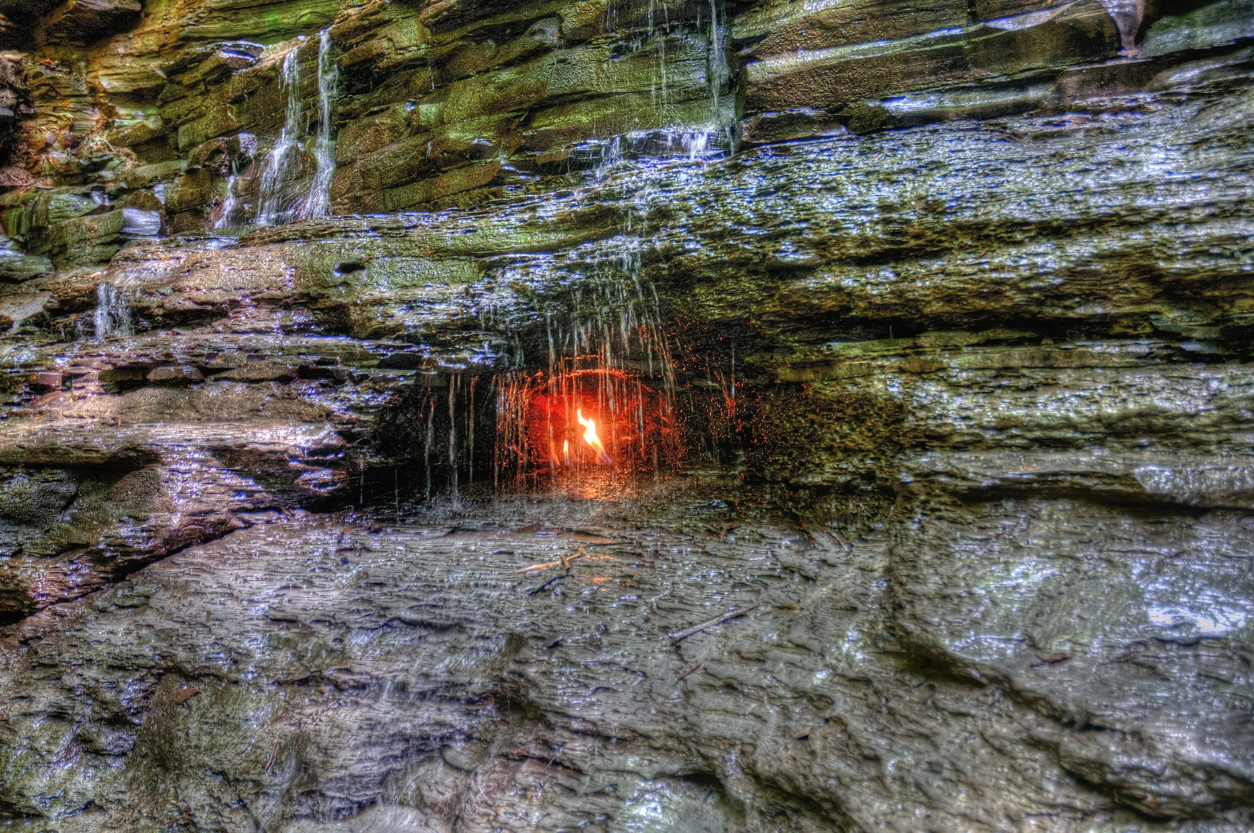
Eternal Flame Falls, New York. Kim Carpenter. CC BY 2.0

Natural gasses, when combined with geologic, volcanic or industrial activities, have led fires that burn for tens to thousands of years. These marvels have created wonder, inspired myths and served as resources. Drawing people from around the globe, eternal flames continue to ignite the minds of travelers.

Baba Gurgur, Iraq

Among a desert scene with a smog-covered background and various buildings in the skyline is a massive burning plume of fire and smoke.

Fire in an oil field, Kirkuk, Iraq. KURDISTAN🌟 كوردستان. CC BY-SA 2.0

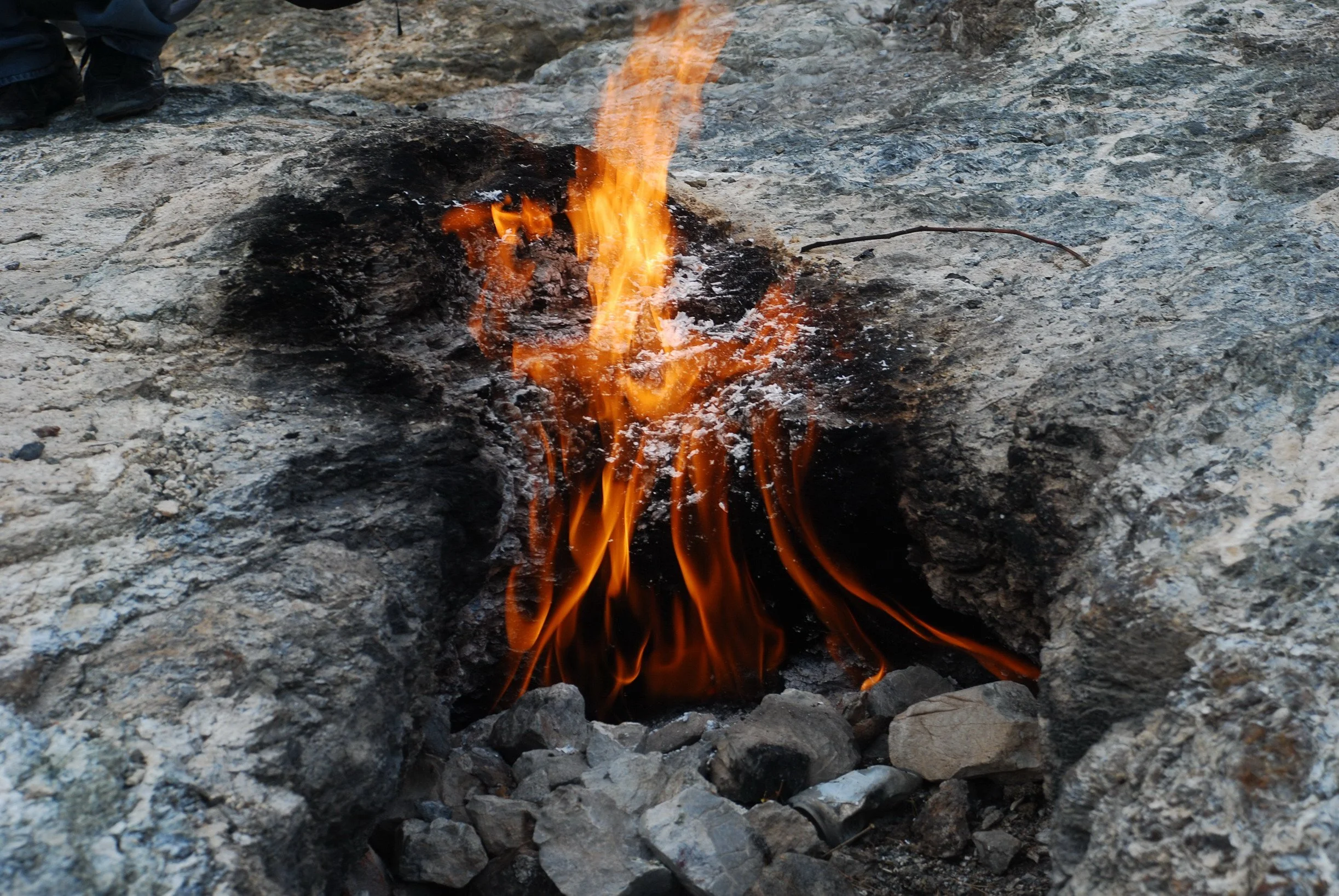
A fire has burned outside of Kirkuk, Iraq for an estimated 4,000 years. Baba Gurgur, roughly meaning "Father of the Fire" in Kurdish, is a circular area covered in holes bursting with smokeless flames. 

These flames are fed by natural gas from beneath the ground combined with flammable liquid derived from petroleum called naphtha. There is ample oil and natural gas at this site, considering Baba Gurgur was the world’s largest oil field when it was discovered in 1927.

In addition to Baba Gurgur, the Citadel is another one of Kirkuk’s primary tourist attractions. Built in the 9th century BC, the Kirkuk Citadel is a UNESCO World Heritage Site containing a market, a church and many mosques.

Burning Mountain, Australia

Smoke seeping out from the ground of a rocky and dusty hill

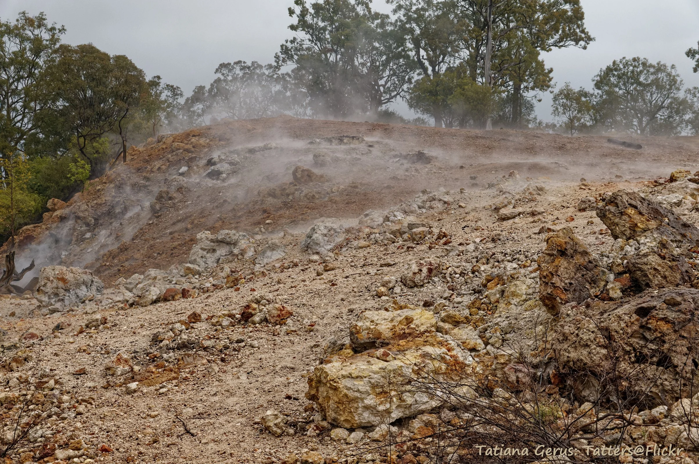
Smoke at the Burning Mountain Nature Reserve, Australia. Tatters ✾. CC BY-NC 2.0

A coal seam that has burned in Australia for an estimated 5,500 years can be found at the Burning Mountain Nature Reserve. Many Aboriginal Australians believe that the smoke and flames of the Burning Mountain are the tears of a woman who the sky god Biami turned to stone. Burning Mountain long served as a source of heat for the Wanaruah people, the traditional owners of the land.

Throughout the two-and-a-half-mile Burning Mountain walk, explorers can find an abundance of viewing platforms and opportunities to learn from informational panels. During an adventure to see Burning Mountain, travelers can also enjoy walks and picnics surrounded by nature and breathtaking views.

Erta Ale, Ethiopia

Lava lake in the Erta Ale volcano, Ethiopia.Thomas Maluck. CC BY-ND 2.0

Ethiopia’s Erta Ale volcano has been home to an inferno for decades. The active shield volcano contains lava lakes in both the northern and southern craters and is Ethiopia’s most active volcano. This phenomenon is a result of three tectonic plates separating and creating channels for magma to rise to the Earth’s surface. 

Erta Ale means the "gateway to hell" in the local Afar language. Erta Ale’s lava lakes have burned since at least 1967, and possibly for over a century, making the volcano home to one of the few consistent lava lakes in the world. Erta Ale has become a popular tourist destination, and travelers can safely witness this natural wonder by taking tours.

The Door to Hell, Turkmenistan

Large flaming crater among an arid landscape with a few mountains dotting the skyline. Sparse tourists walk along the scene.

The Door to Hell, Turkmenistan. Martha de Jong-Lantink. CC BY-NC-ND 2.0

The burning pit in a remote region of Turkmenistan, internationally famous as the "Door to Hell," has burned for over 50 years. The story goes that the Door to Hell was set alight when an oil rig was lit on fire after falling into the crater.

Despite being one of the most closed-off countries in the world, many travelers have successfully ventured to Turkmenistan to experience the roar of the Door to Hell’s flames firsthand.

Home to one of the largest gas deposits in the world, oil and gas are important natural resources in Turkmenistan. Despite many failed attempts in the past, Turkmenistan’s government officials have expressed intent to get rid of the Door to Hell in an effort to conserve natural gas.

The Fire and Water Spring, Taiwan

In a small pool of natural water surrounded by rocks, a flame dances in a little cavern above the spring.

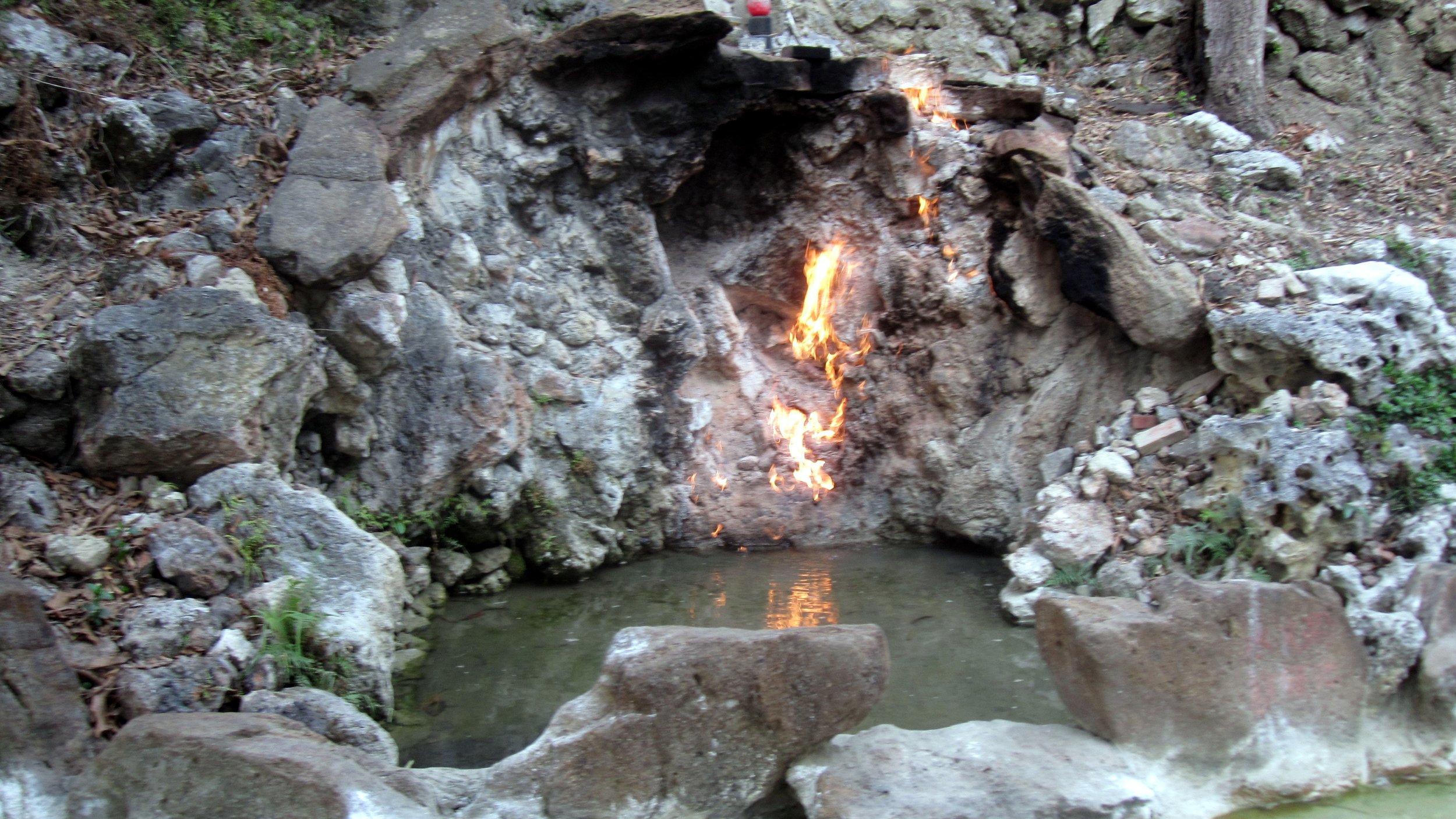
The Fire and Water Spring, Taiwan. Amy Ross. CC BY-ND 2.0

The Fire and Water Spring is a unique place where fire and water co-exist in harmony. Taiwan is covered by fault lines that leak natural gasses such as methane

The Fire and Water Spring is above one of these fault lines, so the water that flows from the cliff walls is accompanied by natural gas. The natural gas, kept alight by the heat of the stone, has burned for over 300 years, according to locals.

During the trek to the Fire and Water Spring, adventurers can come across the Biyun Temple, in addition to a variety of treats like Chinese Mesona provided by street vendors. The Biyun Temple is over 300 years old and is home to many shrines.

Yanartas, Turkey

Small pile of rocks in a small pit under the ground burning in solid flames.

The flames of Yanartaş, Turkey. Veyis Polat. CC BY-NC-ND 2.0

Yanartas, meaning "burning rock" in Turkish, and also known as the Chimera, is a crop of flames coming from rocks that overlook the Cirali village in Turkey. The flames come from methane gas, which has seeped through the Mt. Olympos slopes for thousands of years. 

Some who experienced the flames during ancient times believed them to be the breath of a monster that combined the characteristics of lions, snakes and goats. Now, the flames serve as a pit stop for hikers along the Lycian Way.

The Yanartas is a place of great historical significance. The glow of the Yanartas flames was used as a landmark by sea travelers for centuries. At the entrance of the Yanartas site explorers will find an ancient church, and buried beneath the flames lie the remains of the Temple of the Greek god Hephaestus


Madison Paulus

Madison is a student at George Washington University studying international affairs, journalism, mass communication, and Arabic. Born and raised in Seattle, Washington, Madison grew up in a creative, open-minded environment. With passions for human rights and social justice, Madison uses her writing skills to educate and advocate. In the future, Madison hopes to pursue a career in science communication or travel journalism.

Whale Watching in Washington State in the San Juan Islands

Experience a beautiful archipelago off the coast of Washington State that’s bursting with natural splendor

The rocky coast of Orca Island jutting out into the blue sea. Some pine trees around a small quaint building grow on the island.

The coast of Orca Island in the San Juan Islands. Bureau of Land Management, CC0

Only an hour and a half by ferry from the coast of Seattle, Washington, the San Juan Islands are an incredible destination for any wilderness-seeking wanderers. After only a week, I’d seen dozens of whales and porpoises, and explored miles of the main island both on foot and by bicycle. My friends and I still consider this one of our greatest trips! From whale watching and sea kayaking to hiking and ziplining, these islands provide the perfect “surf-and-turf” nature experience.

The small archipelago is by far most famous for its local orca pods. A rarity in American waters, the Northwest's Gulf of Georgia boasts three local pods that feed primarily on salmon, as well as a traveling pod from Canada that feeds on the local harbor seal population. In addition to the orcas, a wide variety of marine mammals can be spotted both along the shoreline and out in the heart of the Gulf. On our first whale watching tour from the main island my companions and I saw humpback whales, Steller sea lions and a variety of dolphins and porpoises keeping pace with our boat.

The archipelago is made up of four main bodies of land: San Juan, Orcas Island, Lopez Island, and Shaw Island. The first, San Juan, is the largest and most visited island in the chain, and is home to the beautiful town of Friday Harbor. In addition to being the ferry’s main landing point and the heart of the archipelago itself, Friday Harbor is the main hotspot for whale watching tours. The guides provide an excellent experience; ours taught us all about the native marine animals and the history of the islands. We spent most of our time on San Juan during our tour, hiking across the hilly terrain to the south for some amazing views.

A view from above of Friday Harbor. Sailboats are moored among the peaceful harbor and small businesses line the port.

A view of Friday Harbor from the balcony of a local restaurant. Image from author. Ryan Livingston

But perhaps the best thing about Friday Harbor is the locals. In particular a harbor seal named Popeye, who likes to spend her mornings floating outside of the dockside restaurants in the hopes of getting some handouts. She’s very friendly, and has become something of a mascot for Friday Harbor!

San Juan is also the site of Lime Kiln Point State Park, which is lauded as one of the best whale watching sites in the world. The park is also a hangout spot for the river otter population around the islands. Lime Kiln Point is also an excellent hiking spot, with a trail leading up to a vintage lighthouse that is the park’s main landmark. This lighthouse provides an excellent view of most of the Gulf.

On the latter half of our trip, my friends and I paid Orcas Island a visit. Known for its rich artistic history, it is known locally as the “Gem of the San Juans.” The coastal towns include a variety of sailing, fishing and whale watching charters, as well as a few sea kayaking companies that give tours of the island and its history. With their friendly and informative tour guides, you’ll wind up learning about everything from jellyfish to the islands’ border disputes back in 1949! Orcas Island is also the site of Moran State Park, an excellent site for hiking, biking, camping and boating on the small lakes situated across the landscape.

The other two islands are well worth visiting, although I wound up spending all of my time on San Juan and Orcas. Lopez Island is by far the least hilly of the four, and as a result has been adapted into a fantastic biking location. With trails all over the island and tons of rental shops to choose from, Lopez is the biker’s dream. In addition, for any eco-minded travelers, a visit to Lopez Island can include a variety of volunteer opportunities, including trash pickup, injured and beached animal rescue training and more.

Finally, we have Shaw, the smallest island in the archipelago and home to the one-of-a-kind Our Lady of the Rock Monastery. Built on living in the same traditional lifestyle as its founders, the nuns tend a sprawling farm that, like the monastery itself, is open to the public. Although it does offer worship sessions, the architecture and rich history are reason enough to visit.

Whether you’re looking for an escape into nature or searching for the elusive mammals of the sea, the San Juan Islands are a uniquely beautiful experience. The best times to visit are between May and August, when the salmon runs are at their highest and orca and porpoise sightings are the most common. Whale watching tours can be booked out of any of the four islands at places like San Juan Excursions, and hotel bookings can range from $157 to around $300 a night in the heart of Friday Harbor. Camping in the various state parks is also an excellent option.


Ryan Livingston

Ryan is a senior at The College of New Jersey, majoring in English and minoring in marketing. Since a young age, Ryan has been passionate about human rights and environmental action and uses his writing to educate wherever he can. He hopes to pursue a career in professional writing and spread his message even further.

Exploring Iceland’s Westfjords

Delve into the natural beauty and memorable experiences awaiting in Iceland's overlooked northwestern region.

A small town bordering a remote Icelandic snow capped fjord. The water is crystal clear and still, reflecting the mountain and sky.

A small town on a fjord in the Westfjords, Iceland. RaulHudson1986. CC0.

The serene and volcanic landscapes of Iceland have attracted adventurous travelers for many years, especially the popular Golden Circle and Ring Road routes. Yet, both paths exclude one of the most scenic areas of the country, the Westfjords.

The Westfjords of Iceland is a sparsely populated, panoramic region with little geothermal activity that many travelers often overlook. Despite this neglect, there are many amazing experiences here to add to your Icelandic adventure.

1. Dynjandi Fjallfoss Trail  (Arnarfjordur) 

A massive waterfall cascading down the vibrant green mossy rocks and mountainside into river.

Dynjandi Fjallfoss in Arnarfjörður, Iceland. Jacqueline Macou. CC0.

This majestic waterfall is the largest in the region and is frequently referred to as the Westfjords’ most beautiful attraction. It is part of a series of seven waterfalls that unravel down the peak, originating from the waters of Lake Stora-Eyjavatn. The sound that emanates from these falls mimics thunder, and it’s understood why the waterfall’s name, Dynjandi, translates to “thunderous” or “booming." 

From the parking lot, you can hike your way up the seven waterfalls, but take caution as it can be quite slippery and mossy. The average person can do this hike in around 15 minutes, but it is recommended to take your time to enjoy each one. At the peak, you can revel in the mist of the magnificent waterfall, try the fresh glacial water, and look out over the extensive views of the fjord upon your descent. 

2. Museum of Everyday Life–Hversdagssafn (Isafjordur) 

Two women in a dark exhibit in the museum. They smile and look into jars that are attached to a post in the ceiling, all filled with different various object.

Museum guests in the sensory lab in Ísafjörður, Iceland. Courtesy of Hversdagssafn.

This museum provides an intimate perspective on the everyday life of Icelanders that is largely overlooked in mainstream tourism of the island. Founders Vaida and Björg refer to Hversdagssafn as more of an art project under the guise of a museum, one that aims to collect human connection. From exhibits on family histories told through donated books from the old church, short films about the winter seasons and a local distaste of the Northern Lights to heartfelt reflections on being an immigrant in Iceland, this museum is sure to give you a fresh perspective on life in the Westfjords and the pillar of community using all five of your senses. 

3. Hike to Hornstrandir (Hornstrandir)

Hiker crossing a wide shallow river. They are surrounded by a sloping wall of bright green grassy mountainside, with still a patch of snow at the peak.

Hiker crossing the river in Hornstrandir on a trek to Hornbjarg cliff. Kristyna Sindelkova. CC0.

Hornstrandir (​​227-sq-mi) is an uninhabited area of the Westfjords that is only accessible by boat during the summer between June and August. It’s frequently called “Europe’s last wilderness” and deemed a “hiker’s paradise.” All of the homes on the peninsula have been restored since the last farmers left in 1952. 

After establishing Hornstrandir as a protected Nature Reserve in 1975, the area’s 250 species of flowering plants and 30 species of nesting birds have thrived. Up to six million birds nest on the cliffs during the summer, with species including the Atlantic puffin, Arctic terns, black guillemots and penguins. It is the only sanctuary for Iceland’s prized native mammal, the Arctic fox. As the region is uninhabited and the animals are protected, the foxes have no fear of travelers and will often raise their kits near campsites. Polar bears have also been known to drift on ice to Hornstrandir from Greenland, though this occurrence is rare. 

The area’s tundras, cliffs, flower fields and ice prove to be exciting hiking routes for self-sufficient adventurers. You can enjoy the vast region through multi-day hikes or day trips where you can eat traditional cuisine at the Old Doctor’s House. You can also do multi-day kayak tours that weave in and out of the fjords and camp overnight in the wilderness or at sleeping bag accommodations. Guided tours are highly recommended, and booking in advance is required. 

4. Tjöruhúsið (Ísafjörður)

Looking down a residential street in Isafjordur, some houses have bright red picket fences, and are vibrantly painted.

Town of Isafjordur in the Westfjords of Iceland. Gestur Gislason. CC0.

Immerse yourself in this Icelandic fish buffet, only open for dine-in during the summer season, for a communal dining experience with unlimited access to a range of unique platters and local music. It is a family-owned and run restaurant that has no menu, as the restaurant caters to the catch of the day. The atmosphere is warm, welcoming and familial. Plates vary from traditional Icelandic fish stew, to thorskkinnar (cod cheeks), monkfish and more. The restaurant also serves as a meeting space for public events within the community. Reservations for the lunch and dinner serving times during the summer seasons are highly recommended to ensure a seat at the delicious buffet-style gathering.  

5. The Icelandic Museum of Sea Monsters (Bíldudalur)

A small caution sign posted with a cartoon image of a sea monster rising out of the water posted in front of the fjord.

A cautionary sign was posted along the road in Iceland. Dendron. CC0.

Take a step back in time and discover old Icelandic lore and legend of the creatures that may or may not have plagued the Nordic seas. This region is known across Iceland for its historic reputation for prolific sea monster activity. At the Icelandic Museum of Sea Monsters, visitors can witness the extraordinary creatures of the deep vividly portrayed through an immersive and interactive blend of language, visuals and videos. Eyewitness testimonies are paired with scholarly insights into the realm of sea monsters, as on-screen narratives and academic perspectives infuse the space. Moreover, an array of relics and artifacts, serving as tangible remnants, color the museum, offering compelling evidence of their existence. The museum also has impressive interactive maps that draw on all kinds of monster legends from around the world.

Additionally, as you visit the museum, a highly recommended pitstop nearby is Reykjafjardarlaug Hot Spring, a geothermal pool just outside of the town for an ideal rest in warmed geothermal waters. 

6. Whale Watching

People holding onto the rails in front, smiling, while on a small whalewatching boat in the fjord.

Whale watchers aboard a RIB boat in Iceland. Courtesy of West Tours. CC0.

The waters of the Westfjords are home to many arctic species, including up to 20 species of whale. Here you will likely encounter dolphins, humpback whales, beak whales, minke whales and orcas. These polar water tours are frigid and icy and thus can be experienced on more relaxed boat tours. However, if you are looking for a more adventurous and open-air whale-watching tour, you can opt for an open RIB boat safari where you can feel the pulse and spray of the ocean while capturing up-close views of marine life. Most tours depart out of Isafjordur or Holmavik and last two to six hours. Almost all tours guarantee incredible whale and nesting bird sightings. 

A small whalewatching boat in the fjord, as a large whale tail sticks out of the water only a few feet away.

Whale watchers experiencing a whale sighting in Iceland. Courtesy of West Tours. CC0.


Julz Vargas

Julz is a student at Wellesley College studying Anthropology and Spanish. She grew up in Los Angeles, CA, and has studied all around the world in places such as Costa Rica, Greece, Iceland, and Spain. She is passionate about employing writing as a tool to explore human connection and diversity. Julz aspires to foster cross-cultural connections through community-based research, amplifying inclusive and diverse media about global cultures, foods, and people, to encourage individuals to engage more wholly with the world.


Ski Trips Make a Comeback in Afghanistan

Untamed Borders navigates powder and a new administration as adventure enthusiasts transcend cultural and geographical borders

Two people in an open hilly and snowy landscape ski touring.

Tourist Skiing in Afghanistan. Neil Silverton

Afghanistan’s ski slopes have witnessed the return of tourists for the first time since the new Taliban government came into power in 2021. Untamed Borders is a UK based travel company, formed in 2008, that focuses on providing travel opportunities to some of the world's most interesting and inaccessible places. In 2011 it pioneered excursions to Afghanistan, and has recently decided to resume its trips to the non-traditional ski tourism destination.

The group sponsored one trip in the winter of 2024 that lasted from February 22nd to March third. It began in Islamabad, Pakistan and ended in Kabul, Afghanistan. It was a magnet for those looking to experience the region’s rugged yet beautiful landscape. Skiers started in Pakistan, where they received visas, before flying to Kabul and driving to Bamian to spend four days skiing.

A group downhill skiing through a powder field in the vast snowy landscape.

Group Skiing in Afghanistan. Ana Tasič, Untamed Borders

In 2025, the company is set to continue its trips to Afghanistan. For this upcoming year the trip will be set in the Bamian Province once again, with skiing taking place in the Koh e Baba Mountain range. Similar to past trips, travelers are expected to end in Kabul and begin by venturing through Islamabad and Peshiwar, Pakistan. Skiers will have the opportunity to be led by local guides, who will help them explore Afghanistan’s popular slopes and to experience backcountry skiing on routes that may have never been skied before. Travelers will additionally have the opportunity to visit the remains of Bamian’s famous Buddha statues, the ancient city of Shahr e Zohak and take part in the Afghan Peak Ski Race.

Ana Tasič, an international guide for Untamed Borders, emphasized the beauty of the trip to Bamian Province, highlighting the drive through the outskirts of the snowy Hindu Kush Mountains. She explained that it typically takes around four to six hours to get to the Province but that “the journey through the mountains is spectacular.”

A crowd of people hikes up along the mountainside with their skis in tow.

Afghan Peaks Ski Race. Afghan Peaks Charitable Trust.

Each year, the annual ski trip run by Untamed Borders coincides with Afghanistan’s annual Afghan Peak Ski Race. International groups will be offered the opportunity to take part in it alongside locals. The race typically includes two different types of skiing. One race is for people using wooden skis and the other is for those using conventional skis. The competition allows people of all ages to compete, but has faced some challenges that allow women to participate as a result of the Taliban taking over. Tasič, a former teacher of the ski club for girls, mentioned the changes in government over the past couple of years that have prevented the participation of women.

“We can’t do anything with women in sports anymore, so this has definitely changed but there’s not much that we can do about it. We’re hoping that this changes in the next few years,” she said.

The new regime in Afghanistan has not created the need for Untamed Borders to up security considerations. Because the Taliban now run Afghanistan there is less of a worry over unpredictable attacks than before, although getting into the country has become complicated. While some changes have been made in regards to travel planning, Tasič reassured those considering the trip that although “a lot has changed in the last eight years, one thing that stands out is the hospitality of the people there.” She mentioned how the trip is an opportunity for travelers to not just meet locals but to spend a week with them and get to see how they live.

“We get to experience Afghanistan in a way that most people don’t. It’s not just a ski trip, but it’s also a cultural and hospitality trip,” Tasič said.

TO GET INVOLVED

For the 2025 trip, those interested can find more information on Untamed Borders’ website. The trip to Afghanistan costs $2,850 USD and dates are not yet finalized, but when they are they will be posted to the same site for travelers to easily access.


Mira White

Mira is a student at Brown University studying international and public affairs. Passionate about travel and language learning, she is eager to visit each continent to better understand the world and the people across it. In her free time she perfects her French, hoping to someday live in France working as a freelance journalist or in international affairs.


Underwater Paradise: Raja Ampat, Indonesia

With over 70% of the Earth covered by water, it’s only logical for the planet’s greatest beauty to lie beneath the waves. Raja Ampat holds a special place in the hearts of divers and naturalists alike.  

An image of tall limestone islands dotting the turquoise waters and reefs.

Wayang Island within Raja Ampat. Elias Levy. CC BY 2.0.

Situated northwest off of Papua, Indonesia’s most eastern island, the Raja Ampat archipelago is heralded as a top-tier site for scuba diving and marine biodiversity. Raja Ampat comprises over 28,000 square miles of ocean and hundreds of cays and shoals still to be discovered. Plate tectonics exposed ancient limestone seabeds to tidal erosion which yielded a series of islands seeming to levitate above the waves. As the archipelago straddles the Earth’s equator, it naturally experiences a tropical climate. 

But Raja Ampat’s most signature feature is its sheer scope of species diversity. Home to at least 75% of the world’s hard corals and at least 1,500 different species of fish, Raja Ampat is considered the global epicenter of marine animal diversity. Due to a confluence of warm, shallow water and nutrient-rich currents from the Pacific and Indian oceans, Raja Ampat has thrived for decades as a haven for endangered aquatics. A slew of rare sea species from dugongs and blue whales to dolphins and leatherbacks live in relative geographic isolation and pristine marine ecosystems.

  Northern Raja Ampat

A colorful and striped underbelly of a lionfish swimming in the clear waters of Raja Ampat.

Marine biodiversity is unmatched within Raja Ampat. Nazir Amin. CC BY 2.0.

The northern islands of Gam, Kri, Waigeo and Batanta are bounded by the Dampier Strait. It serves as a popular entryway to Raja Ampat thanks to the city of Sorong on the west coast of Papua which hosts its own airport. With mainland access via ferries, most visitors flock to the north to dive at famous sites such as Cape Kri, Blue Magic and Manta Sandy.   

Cape Kri is a renowned hotspot for marine biodiversity. Once recorded as the site with the highest quantity of distinct fish species observed in a single dive, visitors can expect to see reef sharks, moray eels, turtles, Humphead wrasse, cuttlefish, porcupinefish, crevalle jack, snapper and barracuda.

Blue Magic offers a variety of soft and hard coral reefs to check out. Though divers will face strong currents in the water, the struggle is worth the chance to meet dogfish tuna, giant trevally, spanish mackerel, bumphead parrotfish and even octopi.

Manta Sandy is a shallow site teeming with plankton, and of course, ocean manta rays. Divers must try their luck to encounter the rare black manta.

South Raja Ampat

A flat shark camouflaged with the sandy ocean floor.

A Wobbegong shark. Nazir Amin. CC BY 2.0.

South Raja Ampat is noticeably inaccessible to the lay visitor as overnight ferries must be taken from Sorong to reach this remote area. However, the reefs in South Raja Ampat are picturesque, with premier visibility for pygmy seahorses, colorful nudibranchs and other wowing wildlife.

The island of Misool is the pinnacle of biodiversity conservation, as much of the area is protected as part of the Misool Marine Reserve. There’s only one option for overnight lodgings: the Misool Eco Resort, an eco-friendly hotel dedicated to conservation and sustainability. The resort’s founders dedicate a portion of both their profits towards biodiversity recovery; there’s been a 250% increase in local biomass and a doubling of reef fishes within six years. Visitors are welcome to trek or boat to neighboring islands for beautiful beaches, native seabirds and rock petroglyphs dating back 4,000 years.

Hundreds of reef fish are visible from above the water’s edge. Nazir Amin. CC BY 2.0.

Raja Ampat’s natural beauty belies political and economic trouble. 

A brightly spotted fish poking its head out of a coral reef underwater in Raja Ampat

Though visitors will certainly enjoy Raja Ampat’s scenic environments and exotic wildlife, they may feel the effects of local turmoil.

In 1961 the people of West Papua, an area which includes Raja Ampat, voted to become a part of Indonesia in a much disputed referendum. However, a pro-independence movement has emerged throughout Papua, eliciting police and military crackdowns alongside communal tensions. Furthermore, around 9,000 of Raja Ampat residents live in poverty, lacking sanitation facilities and healthcare. Clean drinking water is imported into the islands approximately once a month; there is no electrical or telecommunications infrastructure available for most villagers. Most inhabitants either fish or mine to earn their living, and often incur debts to small businesses for consumer goods and fuel prices. Raja Ampat’s ecotourism industry is partnering with local residents to promote their security and welfare. 


Rohan Ratogi

Rohan is an engineering graduate from Brown University. He is passionate about both writing and travel, and strives to blend critical thinking with creative communication to better understand the places, problems, and people living throughout the world. Ultimately, he hopes to apply his love for learning and story-sharing skills to resolve challenges affecting justice, equity, and humanity.

The Mountain Gorillas of Bwindi Impenetrable Forest

Photographer Laura Grier adventures among gorillas and lions in Rwanda and Uganda.

There are few places in the world where wild animals are unafraid of humans, and you can view them in their own majesty in the wild without cages, tourist vehicles or controlling their environment. The Gorillas of the Bwindi Impenetrable forest of Rwanda and Uganda are on the top of my list as a place where I have been able to come face-to-face with animals and spend the day with them in their environment. Those moments have been life-changing for me.

I led a group of six women and one man to Rwanda and Uganda on a philanthropic adventure trip; all of the locals affectionately called our one token male “Silverback” since the male Silverbacks gorillas always travel with a harem of female gorillas in the forest.

We started our trip in Kigali, the capital of Rwanda, and had a meal in “Heaven”, the restaurant that was made famous by the book “A Thousand Hills to Heaven,” a memoir about one couple and how they healed a Rwandan village, raised a family near the old killing fields, and built this restaurant named Heaven. The authors, Josh and Alissa, newlyweds at the time, were at a party and received a challenge: “Do you think you can really make a difference here in Africa?”

This memoir inspired me to lead this trip and to see if through adventure, we too could all give back and make a positive impact here in Rwanda and Uganda. So it was only fitting to begin our journey right in this spot.

Our first stop was visiting the female artisan weaving collective, Handspun Hope, who are mostly widowed women from the horrific genocide that happened here in the 1990s. Many men were murdered in a two-week period of time, leaving women and children orphaned and widowed and with no way to provide for themselves. This non-profit created a gorgeous, safe oasis for these women to weave and gather together and purchasing these goods helps them to support their families and communities and help lift them out of poverty.

Due to the genocide, Rwanda has received a lot of aid and tourism help from around the world. We noticed a marked difference in infrastructure and wealth between Rwanda and Uganda; Uganda is by far the poorer neighbor. So we decided to stay in an eco-lodge on the Ugandan side of the Bwindi Impenetrable Forest to help support the country’s tourism, and also receive the benefits of the Ugandan side’s lower price tag. 

We spent two days hiking out to see the gorillas. Each morning, groups of trackers leave at sunrise to track the various families of gorillas in the forest, and then a couple hours later we leave in groups to follow their trail and hopefully intercept the great apes. Many of these trackers were once poachers, but now tourist dollars flowing in make the gorillas worth more alive than dead—many poachers have switched to the “good side,” helping to protect these giant creatures.

What I loved was learning about these gorilla groups and how they live. They all have names and very human personalities and soap opera-esque drama. They make nests every night on the ground to sleep in, and often you will find them hanging out in the trees above you. When you do finally spot a group of gorillas, they seem very nonchalant about your presence. It doesn’t matter how many hours it took hiking through thick jungle to find them, once discovered the clock starts ticking and you get only an hour to hang out with them before the rules dictate that you have to leave. You can always spend the next day hiking out to find them again, but you will never know how long that will take. They are always on the move.

Nothing really can describe sitting next to a gorilla in the wild and staring into their faces. They are gentle yet powerful creatures, and more akin to us than different. Their forests are  protected through tourism dollars, one of the few times I feel like tourism is truly benefiting wildlife, since the Ugandans and Rwandans have a deep respect for these gorilla groups. 

After two days of trekking through thick jungles in the cool, misty mountains looking for gorillas, we drove down into the arid savannas of Uganda to visit the Hanging Lions of Queen Elizabeth National Park. This is the only place on Earth where you will find prides of Ishasha lions just hanging out in the high limbs of Sycamore Fig trees. This is a very rare sight, because this unique group of only about 35 lions is endangered due to threats of human-wildlife conflict and retaliatory snaring and poisoning. We drove around in safari vehicles and witnessed gorgeous wildlife, including herds of elephants and hippos and, of course, very full, very happy lions in the trees.


Laura Grier

Laura is a dynamic Adventure Photographer, Photo Anthropologist, Travel Writer, and Social Impact Entrepreneur. With a remarkable journey spanning 87 countries and 7 continents, Laura's lens captures both the breathtaking landscapes and the intricate stories of the people she encounters. As a National Geographic artisan catalog photographer, Huffington Post columnist, and founder of Andeana Hats, Laura fuses her love for photography, travel, and social change, leaving an impact on the world.

5 Cryptids for Well-Traveled Lovers of the Macabre

Cryptids are creatures that have developed cult followings despite their dubious relationship with reality.

Helmingham bestiary and mythical creatures. Rawpixel. CC0.

Cryptids are creatures or animals that cryptozoologists believe exist in the wild, but whose present existence is unsubstantiated by science. Tales of such creatures can be found all around the world and are often the subject of modern folklore. Whether you or not you are a believer, cryptids are a point of fascination for anyone who relishes in the macabre.

1. The Mothman

Point Pleasant, West Virginia

The illusive mothman creature, with red eyes, wings, and a humanoid body. Steve Baxter. CC0.

In the small town of Point Pleasant, West Virginia, it is said that the infamous Mothman creature has haunted the woods and terrorized residents since 1966. First sighted by teenagers driving on State Route 62 near an abandoned National Guard Armory building, the creature is described as being six to seven feet tall with red eyes and wings like a moth. Since its first appearance in the public’s imagination the Mothman has reached mythical status, with statues, restaurants and other tourist attractions erected in its honor.

2. Chupacabra

Mexico and Southwestern United States

The chupacabra is said to feed on human and animal blood. Michael Snipes. CC-BY-SA 2.0

Chupacabras are said to be vampire-like creatures that are often blamed for attacks on goats, sheep and other domesticated animals. According to legend, the creature stands upright and resembles a large reptilian kangaroo. First reported in 1995, many believe the appearance of the Chupacabra in the collective imagination of Mexico and the Southwestern United states was highly influenced by the horror movies of the time. That being said, the Chupacabra continues to haunt the hearts and minds of the Great Basin.

3. J’ba FoFi

Democratic Republic of the Congo

The J’ba FoFi is a giant spider said to live in the Congolese jungle. Flickr. CC0.

The J'ba Fofi, also known as the Congolese Giant Spiders, are a type of large arachnid cryptid said to inhabit the forests of the Congo, hypothesized to be a new species of spider. The J’ba FoFi is said to hunt vertebrates rather than the insects its kind normally consume. The creature creates a network of webbing that operates as trip wires for approaching prey. They are said to burrow under trees and have large, yellow eggs. The existence of this giant spider, whether it is a yet-undiscovered species or simply a myth, remains unclear.

4. Loch Ness Monster

Scotland

Sighting of the Loch Ness monster. Ad Meskens. CC-BY-SA 3.0

One of the most famous cryptids in the world, the Loch Ness Monster is a creature said to inhabit Loch Ness in the Scottish Highlands. It is described as a large animal, with a long neck and often several humps protruding out of the water. Hypothesized to be the last descendant of an extinct species, potentially dating back to the time of dinosaurs, the existence of the Loch Ness Monster has never been confirmed. “Nessie,” as the behemoth is affectionately known to fans, has been the subject of sustained curiosity and numerous hoaxes, capturing the public’s attention despite the creature’s dubious link to reality.

5. Hibagon

Japan

The Hibagon is a Japanese, humanoid cryptid. John Doherty. CC0.

The Hibagon is a Japanese Bigfoot-like creature said to live on Mount Hiba, Hiroshima Prefecture. First sighted in 1970, the Hibagon is described as an ape-like being that walks upright and is approximately six feet tall. There have been many more sightings of the Hibagon since the ‘70s, causing a Hibagon craze that has become a fixture of the local tourist industry. The existence of such a creature remains unconfirmed.


Sophia Larson

Sophia Larson is a recent graduate of Barnard College at Columbia University. She previously worked as the Assistant Editor on the 2021 book Young People of the Pandemic. She has also participated as a writer and editor at several student news publications, including “The UMass Daily Collegian” and “Bwog, Columbia Student News.”

Pathways and Pilgrimages: Exploring The Camino de Santiago

This pilgrimage to the Cathedral of Santiago de Compostela in Spain has been a centerpiece of Christian spiritual life for thousands of years, and a destination for travelers around the world.

The Santiago de Compostela. Dafydd Parri. CC BY-NC-ND 2.0.

The Camino de Santiago, also known as the Way of St. James, marks a pilgrimage to the Cathedral of Santiago de Compostela in Galicia, an autonomous community in northwestern Spain. Extending roughly 500 miles and taking about 30 to 35 days to complete at an average of around 15 miles per day, the Camino is known today both as a center for Christian spiritual life and a hiking haven for travelers looking to submerge themselves in nature with affordable accommodations and opportunities to adventure through local villages along the way.

Today, around 300,000 travelers make their way through the Camino every year, and those who complete the journey earn a Compostela Pilgrims Certificate. According to measurements from 2021, 45% of travelers reported walking the Camino for “religious and other reasons” while 30% reported walking the Camino strictly for religious reasons and 24% said they had no religious reasons for the pilgrimage. The growing popularity of the Camino as a secular travel experience as well as a religious one is aided by its accessibility. While daily expenditures on the Camino depend largely on the town one is stopping in, travelers can plan to budget for about $30 a day to cover the cost of food. Albergues, or hostels specifically made for pilgrims, are also a reliable and affordable option for accommodations along the Camino, with municipal albergues typically costing between $5 to $10 per person, while private albergues range between $12 and $15 per person. Via Lusitana helps connect travelers to albergues along the Camino Portugues.

While there is no exact starting point to the Camino, there are a handful of popular routes to choose from including Camino del Norte, Camino Primitivo, and Camino Ingles. The two most popular routes are that of the Camino Frances, which begins in Saint-Jean-Pied-de-Port in southwest France, and the Camino Portuguese which starts from Portugal’s coastal city of Porto. While the Camino Frances covers 500 miles, the Camino Portuguese offers two distinct routes: the Camino Portuguese Central route which is 385 miles and the Camino Portuguese Coastal route which is 175 miles. 

The Camino became a UNESCO World Heritage site in 1993 and was recognized as the first European Cultural Route in 1987, however its history is one that dates back to the 9th century,  when remains of the apostle James were believed to be found in Galicia. Saint James preached in the Iberian peninsula before returning to Jerusalem, where he was beheaded by the king Herod Agrippa I in 44 AD. The legend surrounding St. James details how his body was transported from Jerusalem to Spain via a boat and was buried by his followers in Galicia in what is now the city of Santiago de Compostela.

The tomb was discovered in the 9th century by the bishop Theodomir. Upon its discovery the King of Asturia, Alfonso II, widely considered the first pilgrim to the Santiago de Compostela, traveled to the site and ordered that a church be built at the place of burial. Construction began in 1075 and the church was consecrated in 1211.

To accommodate an increase of pilgrimages through the Camino in the Middle Ages, bridges and other infrastructure were built along the route to aid travelers. Between the 11th and 13th century, the Camino’s rising popularity gave rise to a network of housing options and medical services along the route, including hospitals chartered by European kings.

The Camino’s many routes  were created by early travelers who shared information amongst themselves regarding the safest travel conditions, which nearby towns to stop in, and where to source food and water throughout the journey. Though lacking official infrastructure,  these paths became well defined by the pilgrims who traveled them for hundreds of years. It was not until the 1980s that Father Elías Valiña Sampedro, a priest of a neighboring Galician village, added yellow arrows along the path in an attempt to prevent travelers from getting lost.

Camino Frances

El Alto del Perdón. Rocco Rossi. CC BY 2.0.

As the most popular route, the Camino Frances sees around 55% of all travelers on the Camino de Santiago. Embarking on the French Way is one of the most social options to experience the Camino, and those who do so are sure to run into fellow pilgrims and have opportunities to build connections and a sense of camaraderie along the way. 

The entire Camino Frances starts at St Jean Pied de Port, a commune in southwest France, and extends roughly 500 miles and takes about 30 to 34 days to complete with an average of about 15 miles per day. However, the most popular starting point for travelers along the Camino is found at the last 60 miles of the pilgrimage, in the city of Sarria. This last stretch of the Camino takes approximately 7 days and passes through the towns of Portomarin, Melide and Arzua. 

Travelers embarking on the Camino Frances will move through the Pyrenees mountain range and into the La Rioja region of Northern Spain. Travelers interested in enjoying the region’s world famous vineyards can explore a variety of wine tours showcasing the region’s diverse earthly flavors.

Other notable traveling stops along the Camino Frances include the Spanish city of Pamplona, whose yearly San Fermín Festival every July features the country’s world-famous bull runs. When the festival is not happening, the Pamplona remains a popular resting spot for travelers along the Camino to explore Gothic and Renaissance art at the Museum of Navarra and the historic Plaza del Castillo where cafes and bars such as Cafe Iruna served as prominent landmarks in American novelist Ernest Hemmingway’s life and writing.   

Another highlight along the Camino Frances is the sculpture of El Alto del Perdon, which shows metal silhouettes representing pilgrims traveling through the Camino on foot and horseback. The art piece is located near the town of Puente de la Reina, a historical meeting point for early pilgrims traveling the Camino through a variety of routes along the Pyrenees. The town’s current architecture derives from attempts to accommodate pilgrims during the Middle Ages, including the bridge constructed under Queen Muniadona to assist pilgrims in their travels. The bridge is responsible for the town’s namesake, with Puente de la Reina translating to “the queen’s bridge.”

Camino Portugues

Travelers on El Camino. Staffan Andersson. CC0 1.0. 

An alternative to the Camino Frances, the Camino Portugues begins in Portugal and moves the coastline up to Galicia as the second most popular path for the Camino de Santiago pilgrimage. The route gained popularity in the 12th century after Portugal gained its independence when Queen Isabel of Portugal, known as the “Holy Queen,” made the pilgrimage herself in the 14th century. Today, the Camino Portugues sees about 25% of all travelers embarking on the pilgrimage. 

There are three main routes that travelers embarking on the Camino Portugues can choose from: the Central Route, which takes around 12 days, the Coastal Route, which takes between 12-14 days, and the Litoral Route, which follows the Coastal Route in large part while also incorporating pathways onto the beach. All routes meet in the Spanish town of Redondela before reaching Santiago de Compostela. 

Each route carries its own advantages and disadvantages. The Central Route has more infrastructure and access to towns and accommodations, however it is also the busiest route, seeing 70% of all travelers on the Camino Portugues. Comparatively, only about 30% of travelers opt for the Coastal Route, making it a quieter experience with less built-in tourism. 

Those starting the Camino Portugues from Porto will get to enjoy the city’s famous local port wine, the Baroque style Porto Cathedral — or Se do Porto — and the boat tours of the stunning Douro River. 

Vigo is a popular starting point for those who want to experience the last 60 miles  of the Camino, and the city offers a variety of activities including fish markets and a coastline overlooking the Cies Islands. 

Services such as Pilgrim help travelers create a personal guide for their trip, curated towards each individual’s preferred route and transportation type — including walking, cycling and completing the Camino on horseback or with pets. Pilgrim also helps connect travelers to special services while on the road, including the options to order bike gear, rent a car and transport personal luggage.  

Online guides are another helpful tool for travelers when it comes to finding rest stops and maps of nearby towns to explore along the Camino


Jessica Blatt

Jessica Blatt graduated from Barnard College with a degree in English. Along with journalism, she is passionate about creative writing and storytelling that inspires readers to engage with the world around them. She hopes to share her love for travel and learning about new cultures through her work.

Frozen Glory: Inside the Eskimo-Indian Olympics

From cultural preservation to sheer athletic spectacle, the World Eskimo-Indian Olympics are a highlight of the Native Alaskan calendar.

An athlete competes in the blanket toss event at the WEIO. KNOM Radio. CC BY-SA 2.0

In the early 1960s, two non-Indigenous pilots who regularly made trips over Alaska’s rural communities kept observing the celebration of an interesting cultural event. This sporting event, as they later came to realize it was, dated back far beyond living memory and honored strength, resilience and endurance through a series of events meant to test the skills necessary to live in such an unforgiving environment. Given that Alaska had just recently become an American state in 1959, the early 60s saw the gradual encroachment of mainstream American culture into its more remote outlying communities, posing a serious threat to local traditions and practices. After the pilots shared their concerns with various groups in Fairbanks, the World Eskimo-Indian Olympics (WEIO) was officially born in 1961 and drew Native participants and spectators from around the Fairbanks area to participate on the banks of the Chena River.

The WEIO has grown significantly since then, with thousands of people traveling to watch the best of Alaska’s Indigenous athletes compete in the Big Dipper Ice Arena for four days each July. Aside from a minimum age limit of 12 years, there are no age categories for any of the events, which means that several generations of the same family can be seen competing against each other. It is also common for older and more experienced competitors to coach and advise the younger athletes during the competition: rather than trying to beat one’s opponents, the larger goal is to compete against and better oneself.

Athletes Sean O’Brien (left) and Chris Kalmakoff (right) compete in the Eskimo stick pull event. Erich Engman. CC BY-NC-ND 2.0

Many of the events, however, are still extremely competitive, and involve intimate face-offs between athletes. The Indian Stick Pull, for example, calls for athletes to wrench a short greased stick from their opponent, an event meant to replicate the grip strength necessary when trying to keep hold of a freshly caught fish by its tail. The Ear Pull is a contest of stamina to demonstrate the athletes’ ability to withstand pain, a valued trait in the often cruel conditions of the Alaskan North. In this event, string is looped around the opposite ears of two athletes as they face each other as they pull away in a tug-of-war with their ears until one cedes the match.

Other events are competed individually, but with just as much rigor and excitement. The Greased Pole Walk, as its name suggests, tests the balance needed for crossing creeks on slippery logs by having contestants walk as far as they can barefoot along a greased wooden pole. A favorite among both competitors and spectators alike, the Two-Foot High Kick requires competitors to jump vertically and kick a suspended ball with both feet before landing and maintaining their balance. Hundreds of years ago, villages along the coast would perform these kicks as a way to communicate to the village that a whale or some other game had been caught, and to prepare themselves to assist the hunters upon their return.

Athlete Ezra Elissoff competes in the Two-Foot High Kick final at the 2021 WEIO. Jeff Chen. CC BY-SA 2.0

Despite the popularity of basketball and ice hockey, the traditional sports seem to be gaining popularity among young children and teenagers, and are also contributing to the difficult task of preserving and passing on Native Alaskan culture. Miley Kakaruk, a 15-year-old athlete of the Inupiaq tribe of Northwestern Alaska, says that she imagines her ancestors competing in the same events centuries ago, vying to be chosen for their village’s next hunting party. Because each event is so heavily rooted in their history, younger competitors are able to learn the customs and stories that so heavily influence the culture and lifestyle of their people.

Equally important is the power of these games to forge a connection between athletes and society. Historically, studies have shown that Native Alaskans suffer from some of the highest rates of alcoholism and drug abuse in the US. A number of the people that the WEIO Board works with and recruits are young adults who are at risk of or actively battling addiction. According to Gina Kalloch, a board member and ex-athlete, discovering their culture through such a fondly practiced social tradition has allowed many of these people to develop a sense of pride in themselves and their culture, and helped to reorient their lives.

Native Alaskan women compete in the Miss WEIO Cultural Pageant alongside the athletic events each year. Danny Martin. CC BY-SA 2.0

While this year’s edition of the Olympics already took place between July 12 and 15, highlights of both the sporting events and the accompanying Miss WEIO Cultural Pageant are freely available on the internet.


Tanaya Vohra

Tanaya is an undergraduate student pursuing a major in Public Health at the University of Chicago. She's lived in Asia, Europe and North America and wants to share her love of travel and exploring new cultures through her writing.

On Top of the World: A View From Mount Everest

Every year, hundreds brave frost, cliff and hypoxia to ascend the world’s tallest peak.

Climbers going up Mount Everest, Nepal. Sam Levin. CC BY 2.0

In 1953, Sir Edmund Hillary made history by being the first to ascend Mount Everest. His journey was a significant departure from the origins of rock climbing, the earliest evidence of which is found in the remains of cliffside dwellings by Native Americans and archaeological burial caves in Mustang, Nepal.

Today, mountaineering has become a popular competitive sport and means of exploring the natural world, with about 800 people attempting the dramatic climb to Everest’s summit each year. Expeditions are reliant on Nepal’s weather, with the best season typically occurring in April and May, before the monsoon, when avalanches are less common. September can also be a good month, but by October the onset of winter storms restricts climbing once again. 

The ascent up Mount Everest utilizes a technique called siege climbing, in which climbers establish a series of camps along their route and sleep at the camp just below them, a technique that helps climber’s bodies more easily acclimate to the elevation. 

Sherpas on Everest

Sir Edmund Hillary was not alone in his groundbreaking climb. In a fact often ignored in the histories, he was accompanied the whole way by Tenzing Norgay, a Nepali Sherpa mountaineer. As a mountain dwelling people of Nepal, Sherpa’s are known for their knowledge of the mountainous region, and have a long history of maintaining and cultivating the land. In a pattern that dates back to Norgay’s first ascent with Hillary, Sherpas today serve as guides to climbers on Mount Everest, while also working to maintain and safeguard the path.

In addition to acting as guides, Sherpa often provide life-saving assistance to straying climbers. In June 2023, a Nepali sherpa guided a Malaysian climber to safety after discovering the mountaineer in the thick of the “death zone”, facing temperatures dipping below -30 degrees Celsius.

The feats and history of Nepali climbers were extolled in the documentary 14 Peaks, which followed Nepali mountaineer Nimsdai Purja on his journey to summit all 14 of the world's 8,000-meter peaks in just seven months. Purja champions the Sherpa’s bravery and the irreplaceable role they play in maintaining Everest’s safety and accessibility for climbers, as well as their knowledge of and connection to the land.

The Costs of Ascension 

The price of climbing Everest has grown steadily with its increasing popularity, and prices in 2023 range between $30,000 to $160,000. The staggering cost includes gear, food, supplemental oxygen, and base camp tents. The support of Sherpa’s is also an important consideration, with the cost of assistance ranging from $2,000 to $5,000. 

The financial toll of ascending Mount Everest is commensurate with its physical brutality. The climb up is  marked by harsh conditions. Altitudes above 25,000 feet (7,600 meters) are known in the climbing community as the “death zone”, and at 29,029 feet (8,848 meters) high, Mount Everest puts climbers in the thick of life-threatening danger. Some of the greatest threats at such altitudes relate to a lack of oxygen, or hypoxia, which leads to rapid breathing and an increased heart rate. High-altitude cerebral edema, or HACE, can also threaten climbers as the body responds to hypoxia with increased blood flow to the brain, leading to swelling that can bring on hallucinations, a loss of coordination, and the potential of a coma or death induced by brain herniation. 

The cost of climbing Everest extends beyond the financial and physical impacts into ecological catastrophe. The world’s tallest summit is now derisively known as the “world’s highest garbage dump.” During the peak season, nearly 500 people make the hike to Base Camp on a daily basis, a physical toll that adds to the erosion of the natural land. Additionally, in the weeks during which they embark to the mountain’s summit, each climber creates roughly 18 pounds or eight kilograms of trash, which include tenting supplies, oxygen containers, and feces.

Mount Everest. Frank Kehren. CC BY-NC-ND 2.0

Clean Climbing

The Nepali government, alongside environmental agencies, has been working to preserve and clean up the mountain. In 1976, the Sagarmatha National Park was created as a means of protecting the mountain’s natural terrain and wildlife. It received recognition and protection as a United Nations Educational, Scientific and Cultural Organization (UNESCO) World Heritage site in 1979.

In 2019, the Nepali government launched a campaign to clean up 22,000 pounds or 10,000 kilograms of waste from Everest. Local authorities now require that each climber pays a deposit of $4,000, which is refunded after the individual returns back from their climb with an equal amount of waste as they are predicted to generate during their climb, approximately 18 pounds of garbage per person. 

Along with local authorities, third party organizations are also working to preserve the future environmental health of Mount Everest. Launched in 201, the Mount Everest Biogas Project aims to create a solar powered system that turns human waste into fuel.

While irresponsible expeditions can lead to increased pollution, the action of climbing is in itself a kind of homage to the environment. Ascending Everest forces climbers to come face to face with the potential harm that human disruption can have on the environment, while reinforcing the importance of environmental protections and regulations. 

With the future environmental health of natural wonders such as Mount Everest at risk, climbing and engaging with nature in an ethical, responsible, and sustainable way can create an important connection between people and the environment. An ascent to the world’s tallest peak can be not only personally enriching, but vital to public perceptions of and future investment in the environment.


Jessica Blatt

Jessica Blatt graduated from Barnard College with a degree in English. Along with journalism, she is passionate about creative writing and storytelling that inspires readers to engage with the world around them. She hopes to share her love for travel and learning about new cultures through her work.

Finding Adventure in Ecuador

A country of volcanoes and valleys, Ecuador offers travelers innumerable ways to push their limits and get their hearts racing.

Swing Jumping in Baños, Ecuador. Courtesy of Jeremy Giles.

The above picture is of me jumping into a 100 meter drop from a bridge in Baños, a city bordering the Ecuadorian Amazon. It took me three tries to actually jump; the first two times I stood on the platform, I got scared and had to come down. I probably only ended up jumping because I saw two people go before me and not die. On the third try, I took a deep breath, knowing that if I didn’t jump then I never would, and leaped off. The adrenaline pumped furiously for one of the longest, most terrifying seconds of my life. Then, of course, the line pulled taut and swung me under the bridge, stopping my fall.

Canopy, Baños, Ecuador, Rinaldo Wurglitsch, CC BY 2.0

Baños, however, is more than just a city I jumped off a bridge in. It has the Andes in the West and the Amazon in the East, making it a beautiful space to see the transition between the two, home to both forests and mountains. Even more, it is the Ecuadorian hub for extreme sports. The entire town center is filled with restaurants and travel agencies, each of the latter offering what felt like hundreds of different extreme sports. Later, on the same day I bungee jumped, I went on a beautiful 6 part zipline system called the canopy, where they let you zipline upside down and even hold hands with another rider. I did it with my friend, but I imagine that if you went with a partner it would be quite romantic.

Paragliding in Ecuador, Jsan92, CC BY-SA 4.0

While Baños may be the center of extreme sports in Ecuador, it's hardly the only locale. During my first month in Ecuador I lived in Cumbaya, a suburb outside of the country’s capital Quito. One of the very first things I noticed was the steady stream of paragliders coming from a mountain behind my house. Almost every day over the next month, I’d see a few paragliders in the sky above me. Eventually I got so curious that my host dad walked me to the paragliders’ landing spot. There we learned two important things. First, while this location is good, it is also possible to paraglide on a mountain next to Quito, which is the prime location for the sport and on my bucket list of things to do when I return to Ecuador. Secondly, we saw on the ground below the paragliders a hopeful fiance-to-be had written a marriage proposal. We didn’t stay to see if the proposal was accepted, but I wish them the best of luck.

Chimborazo, Ecuador, André Hübner, CC BY-SA 3.0.

In Ecuador, a country smaller than Colorado, there are 47 volcanoes, 32 of which are on its mainland. The tallest volcano (and mountain) in Ecuador is Chimborazo, whose summit is a 6-9 hour climb, but provides such beautiful vistas as to make the trip well worth the effort. The peak of the volcano, due to the bulge of the Earth around the equator, is the farthest point from the center of the Earth on the planet’s surface. While Chimborazo was thought to be extinct, it has recently been found to be a still-active volcano. 

Cotopaxi from Iliniza, Jo Simon, CC BY 2.0.

With that said, there has never been a doubt the Cotopaxi volcano, Ecuador’s second-tallest mountain, is active. Cotopaxi has erupted at least 50 times in the last 300 years. It is perhaps the most popular climbing destination in Ecuador, and towers over Quito, making its amazing views easily accessible.

If you’re interested in these experiences, offers for them can readily be found both on-site and online. Bungee jumping and zip lining in Baños costs about $20-40 per person and the paragliding near my home in Cumbaya was approximately $60-75, although I imagine it would be a bit more in Quito itself. Mountain climbing depends on the mountain and your individual plans.


Jeremy Giles

Jeremy is a Writing Seminars and International Studies major at Johns Hopkins University. He is an avid writer and the Co-Founder of Writers’ Warehouse, Johns Hopkins’ first creative writing group. He is an advocate for Indigenous rights, and studies how Indigenous philosophies can be used to help prevent climate change. Using his writing, he hopes to bring attention to underrepresented voices in today’s world.

Filming "Beyond the Surface" in India

“Unite those with positive minds and compassionate hearts and good things happen…” I thought to myself, after meeting Emi Koch in San Diego and chatting with Crystal Thornburg-Homcy about her idea to make a unique surf film in India.

She and her husband, renowned filmmaker, Dave Homcy, planned to document Emi’s work in India under her NGO, Beyond the Surface International, and other inspiring cases of youth and women’s empowerment through surfing, yoga, and ecological creativity. 

On a scouting mission, they serendipitously met Ishita Malaviya, India’s first female surfer and a powerful voice for Indian women, who happily agreed to accompany us on the adventure. Shortly after, Damian Handisides of Free Theo Productions joined the team and the project’s momentum became unstoppable. I was honored to be a participant, along with Lauren Hill who is the founder of The Sea Kin, and Kate Baldwin, yogini extraordinaire. 

We all met in India from our various points on the globe this past April with the hope of exchanging light and love with the people we met along the way, especially those facing poverty, gender inequality, and social disparity. At the same time, the adventure would be a platform of growth for our own individual paths of self-realization. Our three unforgettable weeks were abound with surprises, beauty, surf, and new friendships while touring and filming in southern India. We explored together in search of a deeper connection to our fellow humans and Mother Nature.

Learn more about Beyond the Surface here.


Liz Clark

Liz is a professional free surfer, writer, environmental activist and adventurer who has captained her 40ft sailboat, Swell, over 18,000 miles on a surfing expedition in the Pacific since 2005. Through her website/blog, she shares her journey with the world in an effort of inspire people to live out their passions, spend more time in nature, engage in self-awareness and personal growth, and develop a consciousness of their everyday planetary impact.

How Ancient Ghanaian Culture Shapes Sea Turtle Conservation

Ghana’s ancient admiration for sea turtles has inspired a modern conservation movement to protect these ecologically vital animals.

Sea turtle swimming in the ocean. Belle Co. CC0. 

Ghana is a vibrant country located in West Africa, bordered by Côte D’Ivoire, Burkina Faso and Togo. It is known for its rich culture, stunning beaches, and diverse wildlife. As a traveler, you would likely find Ghana to be a lively country, full of colorful markets, bustling streets, and a unique mix of traditional and modern cultures. Perhaps most importantly, Ghana is known for the warmth and hospitality of its people, where you’ll be met with a welcoming and friendly nature.

Ghanaian people are also very spiritually attuned, whether it’s native African spirituality or more newly introduced Christianity. They are very fond of their cultural and religious traditions, one of which is long-standing is their long standing connection to sea turtles. 

Sea turtles have been a part of Ghana’s culture and folklore for centuries, with oral literature depicting these animals as protectors, helpers or even guides. Moreover, the reptiles are integral to Ghana’s ecology, as they help to maintain coral reefs and seagrass, which in turn ensure continued biodiversity. 

It wasn’t always this way, as with Urbanization came poverty, and with poverty came poachers. These poachers saw the Sea turtles not as protectors but as a source of profit. Now, having returned to their traditions, Ghanaians are more determined than ever to protect and conserve these animals in hopes to prevent their extinction. 

All over Ghana, there are different recorded myths and stories that show the ancient connection between Ghana and sea turtles. 

The Ga and Akan ethnic groups of central Ghana have a story about their ancestors and how they once were caught in a storm while fishing, in which their boat had sunk. It is said that as the men were struggling in the choppy waters, the sea turtles arrived and helped them get back to shore.

The Dange people of eastern Ghana have a story in which their ancestors were trying to retreat after Ashanti armies had them cornered against the Volta River. They recount how both the crocodiles and the sea turtles helped them safely cross the river, by having the crocodiles form a bridge, while sea turtles helped heal the injured and guided the elderly across. It is said that to this day, both animals are fully protected in this region of Ghana.

Sea turtles in Ghana have been protected by law since 1971. Even then, there are still poachers, so just that isn’t enough. The Ghana Turtle Research Project (GTRP) has been around for more than 10 years. The organization encourages community members to participate in sea turtle conservation and to embrace their culture and traditions. By doing so they were able to get more than fifty community members to form a volunteer network. They also helped to tag and identify where turtle species reside most often in order to make sure that fishermen avoid those areas and to ensure they are safe-guarded.

Additionally, the Environmental Justice Foundation (EJF) is an organization that was focused on protecting nesting sites in the fishing communities of central Ghana. In 2019, during the first turtle nesting season (of that year), they were successfully able to deter poachers from the Goma Fetteh region.

As more and more Ghanaian communities return to their traditional and spiritual beliefs, more people are caring about the sea turtles. It’s due to the oral traditions in Ghanaian culture that these conservation efforts were possible, as they make people care more about these creatures of the sea. They helped form an everlasting connection between the sea turtle and man.


Kadija Diallo

Kadija is a student at Georgia State in Atlanta, Ga. She is a creative spirit who loves traveling and seeing new places. She also enjoys using her love for writing/storytelling to make an impact on the world. One day she hopes to make new connections and share stories as she travels to every continent. 

The Ice Marathon: Racing Through The Antarctica

The Ice Marathon takes place in Antarctica, known to extreme athletes as the Southernmost Marathon in the world.

Ice Marathon finish line. Rosana Katinas. CC BY-SA-4.0.

The Ice Marathon is an event geared towards committed runners who seek to compete in extreme conditions that guarantee once-in-a-lifetime experiences. Held in Antarctica, the Arctic Ice Marathon is known as the southernmost marathon in the world and is scheduled this year to occur on December 13th, 2022. It also gains most of its notoriety for the conditions under which the run takes place; sub-zero temperatures, snow and ice-covered parts of the course, and  certainly the location that makes this race just as much of an adventure as it is a competition.

The race is said to take place in the area below the Ellsworth Mountains, which is the highest mountain range in the arctic and just “a few hundred miles from the South Pole”. Like any marathon, the Arctic Ice race is 26.2 miles long, and what makes this run so challenging is the climate and the terrain. The cold and the underfoot terrain, which is a term used to describe course conditions, create daunting obstacles for any participant competing.

Ellsworth Mountain range. Nasa Goddard Photo and Video. CC BY 2.0.

The first challenge that presents itself to participants is the cold. Antarctica’s temperature averages around 0 degrees celsius during the month of December, which is when the race takes place, but conditions have dropped to -25C in the past. Those who have previously participated in the Arctic Ice Marathon have been known to try and simulate the cold to prepare themselves for the climate by placing treadmills in freezers and running in the artificial cold.

Specific gear is also required. The Ice Marathon’s event website says that wind pants, a down jacket and insulated boats are absolutely necessary to compete in the event. Additional requirements for runners include wool socks, fleece pants and shirts, sunscreen and polarized sunglasses, along with a few more generally required items. 

The second most challenging part of the race is the underfoot terrain. The Ice Marathon website states “the course will be groomed beforehand so it should be reasonably solid, but [is] not always”. This means that though there will be no deep snow on the course, there may be slippery ice and spots where the snow is not as tightly packed, causing the terrain to be more “energy sapping”. Advice for any athlete training for the ice marathon is to practice on sand or any other irregular or uneven terrain.

The fee to enter the marathon is $19,500. This provides the runner with their choice of race – the Arctic Ice Marathon offers a half-marathon and a full one – flights, stays and meals to and from Antarctica, and additional merchandise and photographs of the experience. The entire travel and race experience is 6 days.

Designed to entice adventure-seeking athletes, the Arctic Ice Marathon course is a prerequisite to joining the 7 Continents Marathon Club, which athletes can join once they have run and completed a marathon in every continent in the world. With over 300 members, the 7 Continents Marathon Club is an amazing way to commemorate the hardwork and dedication of marathon runners.


Ava Mamary

Ava is an undergraduate student at the University of Illinois, double majoring in English and Communications. At school, she Web Writes about music for a student-run radio station. She is also an avid backpacker, which is where her passion for travel and the outdoors comes from. She is very passionate about social justice issues, specifically those involving women’s rights, and is excited to write content about social action across the globe. 

South Africa’s Town of Penguins

The small port town Simon’s Town is full of amazing marine life, most notably the African Penguin colony that is  just outside the town center.

Jackass Penguins Simon’s Town SA. Donnie Ray. CC BY-NC-ND 2.0

Located on the southwestern coast of South Africa, Simon’s Town is a small village surrounded by both the ocean  and the mountains. Being so close to Cape Town, Simon’s Town is a beautiful, small port city. 

Simon’s Town is on a part of the Cape Peninsula known as False Bay. This area is a Hope Spot, an important and protected area for the ocean’s health. It is a valuable area for wildlife, with various species of birds and marine life coming to live off the area. Large marine creatures such as dolphins, whales, seals and sharks can be found near the town, some close enough to see while kayaking and others closer to Seal Island, 8 nautical miles away from the harbor.

However, much smaller than these other sea creatures is Simon’s Town’s famous attarction –the penguin colony. Penguins are found on every continent in the Southern Hemisphere, all the way from the Galápagos Islands at the equator to Antarctica. Here in this small town in South Africa, one colony of African penguins known as the Boulders Colony regularly comes ashore. Because of the colony, the town is also named Penguin Town. Breeding season for these birds is between February to August, so it is more common to see penguins during those months, but the birds will also come to land while they are molting. People can watch them from afar, and even swim alongside them, as long as they don’t get too close or chase them because the penguins will bite.

Simon’s Town (9). Joe Pyrek. CC BY-SA 2.0

African penguins–also known as black-footed penguins, Cape penguins, and jackass penguins (the last one because of their unique braying-like sounds)–are an endangered species of penguins, with only around 140,000 penguins in the world. They are small birds, only growing between 24-27 inches and weighing around 8-9 pounds. In addition to the black backs and white fronts, they have a black, parabolic band across their chests, though chicks and juvenile members are brown and gray. The population of this species started declining in the 1980s due to commercial fishing and oil pollution. Though penguins do eat more than just fish, it is the largest part of their diet and commercial fishing has been taking all the species that the penguins eat. Luckily, commercial fishing has been banned in False Bay, so African penguins’ food supply belongs to them and the other sea creatures again. The oil pollution is another serious issue for the birds because the oil will destroy their waterproof feathers, making it hard for them to swim.

There are 27 breeding sites for African penguins, and each of them is a protected habitat, including Simon’s Town, though the town did have to erect fences and boardwalks to prevent the penguins from wandering too far inland and into people’s gardens and backyards. The entire area is a sanctuary for penguins, and keeping them from invading residents’ properties can help people respect the animals, as well as helping the number of penguins to increase.


Katherine Lim

Katherine Lim is an undergraduate student at Vassar College studying English literature and Italian. She loves both reading and writing, and she hopes to pursue both in the future. With a passion for travel and nature, she wants to experience more of the world and everything it has to offer.