8 Reasons to Visit Oman

Oman is truly a feast of the senses—a remarkable getaway for anyone seeking a fulfilling adventure.

An image of the gran mosque, organized hedge garden, and mountains in the background

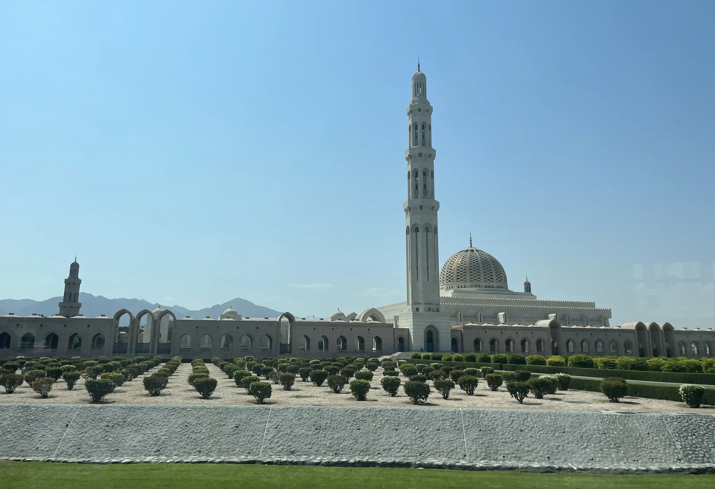
The Grand Mosque in Muscat, Oman. Madison Paulus

After returning from study abroad in Oman, I have a newfound admiration for the country’s history, culture, views and activities. The vitality of Omani culture despite outside influence is admirable and I could see it reflected everywhere I went. From the very first day, I felt welcomed and immersed within the Omani lifestyle. This trip was an incredible experience, inspiring me to share eight reasons why you should experience Oman.

1. Rich History 

View of a fort, two people stand on a balcony taking a photo over the sandy walls.

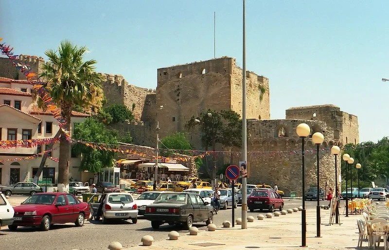
View of a mosque from the Nizwa Fort. Madison Paulus

Oman is the oldest independent nation in the region, brimming with about 1,000 well preserved historical sites. While civilization in Oman began around 100,000 years ago, many popular historical sites came about during Portuguese occupation between 1507 and 1650. 

In Muscat, the capital of Oman, explorers can find several forts. The Muttrah Fort, which the Portuguese built in 1507 can be found at the heart of Muscat's coast. Here, travelers can gaze upon 500-year-old lookouts. 

The Mutrah Fort serves as a vantage point for travelers as it is nearby several other must-see spots, including the Mutrah Market, Al Alam Palace and the National Museum of Oman. Many other castles and forts can be found strewn across Oman, including the Nizwa Fort and Jibreen Castle.

2. Fruitful Culture 

A street vendor man in apron etching a design into handmade clay vase. He has other ornate vase designs on the table in front of him.

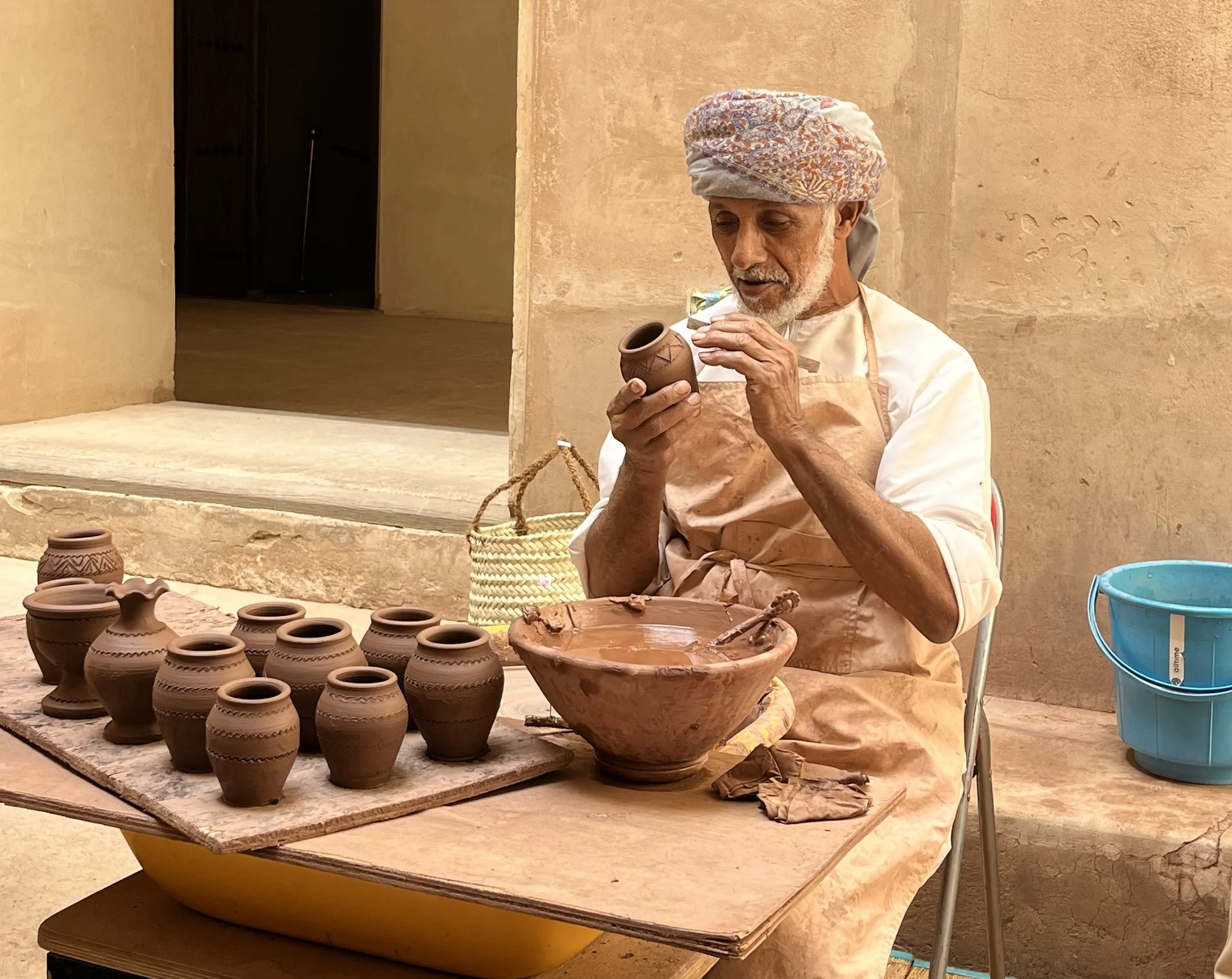
A man making pottery at the Jibreen Castle. Madison Paulus

Oman boasts an impressive blend of cultures. The Omani empire once ruled an area spanning from the east coast of Africa up to present-day Oman. Because of the vast territory and major role in trade, African, Arabian and Asian influences can be found embedded within Omani culture.

Home to more than 130 various types of traditional dances and music, Oman’s performance arts delight travelers and locals alike. Omanis are also expressive through their dress. Women can often be seen in vibrant clothing featuring intricate designs that are unique to each region. Men wearing dishdashas dot the streets, sometimes sporting traditional Khanjars (daggers) on special occasions.

Omani hospitality is another key feature of Omani culture. Omanis are known to be warm and welcoming to travelers, sure to offer friendly interactions and generous gifts for guests including coffee, dates and frankincense. For those searching for opportunities to immerse in Omani culture, there are many festivals open to travelers, including the Muscat Festival and the Salalah Festival.

3. Culinary Diversity 

Looking from above at 12 bags of various spices at an Omani market.

A variety of spices at the Nizwa Market. Madison Paulus

As with the culture, Omani food features Arabian, Asian and African influences. Some renowned Omani dishes include Shuwa, Rukhal bread and Halwa. Shuwa is a unique dish saved for special occasions. Meticulously prepared, Shuwa consists of meat cooked in a clay oven underground for up to two days, giving way to a tender, spice-filled delicacy.

Rukhal bread is a delightful addition that can be found accompanying any meal. Traditionally cooked over flaming palm leaves, Rukhal bread is round and thin, often served with honey or date syrup in the morning or sprinkled across meat and rice dishes throughout the rest of the day. 

Halwa is a labor of love, often symbolic of Omani hospitality. A sticky, gelatinous treat, Halwa is usually made by combining water, ghee, corn flour, sugar and additional flavorings such as rose water or saffron in a large copper pot. Beyond the restaurants and markets, an ideal place where explorers can indulge in Omani cuisine is the Muscat Eat Food Festival.

4. Unique Commodities 

Display of Amouage perfumes lined up on a gold-foiled shelf.

A display of Amouage perfume at the Mall of Oman. Madison Paulus

With an abundance of frankincense and other natural resources, Oman is home to many exceptional goods. Fragrances in particular are an Omani specialty, and Amouage is an exhibition of this expertise. A popular Omani luxury fragrance brand, Amouage draws from Oman’s natural wonders to create enchanting scents, incorporating locally sourced rock roses, ambergris and frankincense. 

While the products aren't budget friendly for many people, travelers can tour the only Amouage factory in the world for free in Muscat, getting a behind-the-scenes look and while sampling their extravagant fragrances along the way. 

If perfumes aren’t your thing, the smell of burning frankincense and oud can be experienced all over the country. For those who wish to bring the essence of Oman home with them, these products, along with traditional burners, can be found easily at shops and markets.

5. Vibrant Art

An array of hand-woven bags, hats, and baskets hung from the walls of a small shop.

Hand-woven baskets on display at the Nizwa Market. Madison Paulus

Many art forms have been intertwined with Omani culture for thousands of years. Pottery is a 5,000-year-old tradition in Oman that is still present across the country. Holding great historical value, pottery has been integral in the lives of Omanis for thousands of years. 

While pottery today is often decorative, its historical and cultural value has been maintained here. In the ancient Omani state of Bahla, explorers can buy pottery from local sculptures or even learn how to make their own at the Al Adawi factory. 

Other intriguing Omani handicrafts include basket weaving and silversmithing. Hand-woven baskets made of date palm or other natural fibers can be found in markets across the country, and travelers can witness the process in action at the Nizwa Fort. Silver goods like khanjar (daggers) and jewelry can also be found throughout Oman’s markets, symbolic of Omani heritage and good fortune.

6. Comfortable Climate 

View of the palm-tree covered landscape of Oman.

A view of the landscape from atop the Nizwa Fort. Madison Paulus

Oman’s weather and climate vary significantly by region, easily accommodating travelers’ preferences. With the interior's dry deserts surrounded by southwest summer monsoons and hot, humid coastlines, Oman offers a warm getaway whether you like sun or rain.

Because of this variation, Oman is a year-round destination, with northern Oman attracting many during the months of October through April, and the South drawing explorers most during July, August, and September, according to a presentation by Zahara Tours.

7. Natural Wonders 

Two camels sitting in the red sand of the Omani desert, red dunes are in the background.

Camels sit in the sand outside the Arabian Oryx Camp. Madison Paulus

Oman’s ecosystems feature a huge diversity of plants and animals, from rock roses and apricots to turtles and camels. With 20 official nature reserves, travelers are offered a wide array of destinations to appreciate Oman’s natural beauty from the mountains to the sea.

Some iconic destinations for explorers to witness nature at its finest include the Al Jinz Turtle Reserve and Daymaniyat Island, where you can swim with whale sharks as they migrate south every summer.

With several caves beneath the earth and many wonders like waterfalls and valleys above, Oman’s astonishing ecology is situated in equally breathtaking natural landscapes. 

8. Adventurous Activities 

A neon-lit boat navigating the deep blue ocean.

A Dhow boat sailing in the Gulf of Oman. Madison Paulus

Travelers itching for activity have countless options in Oman. Hikers will feel right at home, with many trails at varying levels of difficulty found throughout the Hajar and Musandam mountains. 

Travelers can also explore the desert on camel-back or by riding on ATVs. The Arabian Oryx Camp is a perfect spot for either, in addition to offering Bedouin-style accommodations and authentic Arab cuisine.

For those who prefer to spend time in the water, Oman’s nearly 1,300 miles of coastline offers beaches where travelers can swim and snorkel through blue waters.


Madison Paulus

Madison is a student at George Washington University studying international affairs, journalism, mass communication, and Arabic. Born and raised in Seattle, Washington, Madison grew up in a creative, open-minded environment. With passions for human rights and social justice, Madison uses her writing skills to educate and advocate. In the future, Madison hopes to pursue a career in science communication or travel journalism.

5 Adventures in Borneo

Borneo, the third-largest island in the world, boasts an enriching culture and a variety of adventurous nature excursions.

Bohey Dulang—Borneo. JohnJoDeery. CC by 2.0.

Borneo, an island located in the southwestern portion of the Pacific Ocean, is the third-largest island in the world, and the only one that is shared by three countries—Malaysia, Indonesia, and Brunei. The Malaysian part of the island consists of the two states Sabah and Sarawak, with Indonesia holding sway over five provinces in what its citizens Kalimantan and Brunei possessing the smallest section of land named after the country itself. As a part of the Greater Sunda Islands group, Borneo is bordered by two other islands, Sulawesi to the east and Sumatra to the west. The island of Borneo has approximately 292,000 square miles of territory in total, and harbors a significant population of 21.26 million people. Even divided, Borneo is an intriguing and obscure place that most travelers are not aware of; its hot and humid climate makes for an ideal tropical destination. From the soaring heights of Mount Kinabalu to the mysterious depths of the Mulu Caves, the island provides many opportunities for adventurers.

Map of Borneo. Peter Fitzgerald. CC by 2.0.

Sea Diving in Sipadan Island

Scuba Diving in Sipadan Island. CC0.

Sipadan Island, located in the Celebes Sea and situated off the northeastern coast of Borneo, is renowned as one of the world's premier dive destinations, known especially for its marine biodiversity and pristine coral reefs. Diving in the waters surrounding Sipadan offers a scenic experience, where the coral gardens provide a backdrop to an incredible array of marine life. Schools of barracuda, jackfish and sea turtles are all present in these waters, so they’re easy to spot. The island's underwater landscape, featuring dramatic drop-offs and caverns, adds an element of excitement to the exploration. With its protected status as a national park under Sabah Parks, its limited dive permits and its no-fishing policy, Sipadan ensures a sustainable underwater environment, allowing divers to witness the beauty of the ocean.

Exploring the Ancient Mulu Caves

Caves of Mulu. Eric Lanning. CC by 2.0.

Exploring the Mulu Caves in Borneo involves a journey into the depths of one of the world's most fascinating landscapes. Situated in Gunung Mulu National Park, a UNESCO World Heritage Site, the Mulu Caves system is a network of limestone caverns, tunnels and chambers, shaped over millions of years. The expansive caves are full of stalactites and stalagmites, creating an otherworldly environment that transports visitors into a space of natural wonder. The Deer Cave, one of the largest subterranean passages globally, impresses with its vast chambers. Adventure-seekers can also participate in guided tours, which include crossing rope bridges and navigating through passages, providing a sense of exhilaration.

The World's Largest Floating Village in Brunei

At Kampong Ayer. Watchsmart. CC by 2.0.

Kampong Ayer, often referred to as the "The World’s Largest Floating Village," is a water town situated in the heart of Bandar Seri Begawan, the capital of Brunei. This settlement is one of the largest global stilted communities, consisting of intricately connected houses, schools, mosques and markets that rise above the Brunei River on wooden supports. The village has a history dating back centuries, with traditional wooden architecture and a lifestyle deeply rooted in the water. Approximately 13,000 people still reside in their traditional houses, and instead of using roads or cars as methods of transportation, water taxis take residents from one place to another. The water village showcases a unique way of life that one doesn’t see often, and it has endured for generations in Brunei.

Outdoor Adventures in Kalimantan

Batang Kawah River, West Kalimantan. DN.Zrr. CC by-NC-SA 2.0.

Kalimantan, the Indonesian portion of Borneo, is a treasure trove for outdoor enthusiasts seeking thrilling adventures and nature. The region is renowned for its dense rainforests, winding rivers and diverse wildlife, creating the opportunity for a variety of outdoor activities. Adventure seekers can embark on multi-day treks through the rainforests, seeing tropical flora and fauna and perhaps even getting the chance to discover orangutans. The rivers of Kalimantan offer opportunities for exciting activities such as white-water rafting, with rapids making the excursion more fun. For those seeking a more serene activity, cruising along the territory's scenic rivers on wooden boats provides a tranquil way to take in the breathtaking surroundings.

Hiking at Mount Kinabalu

Mount Kinabalu, Borneo. Paul Williams. CC by-NC 2.0.

Hiking Mount Kinabalu is an experience that beckons adventurers to the landscapes of Borneo. It is a challenging hike and rigorous pace, and usually can last around two days. As Southeast Asia's highest peak, standing proudly at 4,095 meters (13,435 feet), Mount Kinabalu dominates the Malaysian state of Sabah. The ideal time period for completing this excursion is between March and April. The ascent begins in the foothills and takes hikers through the ecosystems, from rainforests to meadows. There are even different routes you can choose to partake in, including the Ranau and Kota Belud Trails. The journey reveals panoramic views and a variety of flora and fauna—including 5,000 types of plants, 326 different birds and over 100 mammal species all on this single mountain. Mount Kinabalu, because of its partially difficult trek, is a physical accomplishment that leaves a lasting impact, making it a must-see in Southeast Asia.


Riley Baker

Riley Baker is a first-year student at James Madison University majoring in Writing, Rhetoric, and Technical Communication.  She enjoys elements of storytelling and creative writing and likes listening to music. In addition, she is interested in journalistic-style writing and editing, and intends to focus on writing articles about lesser known travel locations and impactful world topics.

Unraveling the Mysteries of Rapa Nui (Easter Island)

Uncover Rapa Nui's mysteries, sustainable allure, and colossal moai on Easter Island.

Some of Rapa Nui’s stone statues (moai) watch as the sun sets behind the island. Antonio Sánchez. Unsplash.

Rapa Nui is a remote Polynesian island located 2,200 miles off the coast of Chile that spans only 63 square miles. The island is also known as Easter Island, a name that comes from Dutch explorers who arrived there on Easter Sunday in 1722. Rapa Nui gets its distinct triangular shape from the lava beds of three extinct volcanoes and is home to just a few thousand permanent residents. Despite this small population, the island has managed to land itself on many travelers’ must-see destination lists. The island is home to hundreds of imperious humanoid statues whose mysterious past have captured the attention of more than 100,000 visitors a year.

Travel Highlights

Like many other island destinations, Rapa Nui has beaches to enjoy in addition to a broad range of places to spend the night. Given the island’s many environmental concerns such as rock erosion and rising sea levels, there has been considerable focus on working toward a sustainable tourist industry. As such, Rapa Nui has several ecolodges that are popular with travelers. There is an abundance of fresh seafood, places to snorkel and opportunities to hike (Rapa Nui is a UNESCO-designated national park, making up 42% of the island). While walking around, visitors may be able to spot some of the wild horses that roam freely across the island; there are remarkably few indigenous plants, however, with only 31 wild flowering plants. The island’s three extinct volcanoes (Rano Kau, Poike, and Terevaka) also offer a chance for a unique exploration experience. 

The biggest draw of Rapa Nui is its moai. Most understand these statues as being representations of the ancestors of the Polynesian islanders who discovered the island over 1,000 years ago. Some moai have pukao, which are red ornaments that rest on some statues’ heads, and some moai sit on platforms. An ahu, where a number of these platforms can be found, was the traditional center for ceremonies on Rapa Nui. For visitors, the two most popular locations to see moai are at the Rano Raraku quarry and at the Ahu Tongariki. Although the average height of moai is 13 feet, these impressive sculptures can get as large as 80 tons and 33 feet tall. Archaeologists have determined that moai were originally made of basalt, trachyte and red scoria, but eventually moved to volcanic rock. The method of transportation for these especially large moai has sparked numerous theories and debates, with no plausible way for the statues to be moved from their place of creation to their final resting places with the resources available at the time. 

A close-up photo of a giant moai set against the Rapa Nui hillside. Thomas Griggs. Unsplash.

The Mysteries of the Island

Nearly every part of Rapa Nui’s early history has been met with some dispute; even the date of the Polynesians’ arrival has major discrepancies. One archaeological dig determined that humans first made contact with the island around 1200 A.D. This date is contested, however, with others believing that Polynesians found the island as much as 400 years earlier. The inconsistencies in archaeological data and lack of concrete evidence has led to numerous excavations being run and an abundance of people hypothesizing about the island, especially in regards to the Rapa Nui people’s process of moving the moai and how the population declined so quickly. Most of the speculation is about the time before the Dutch first arrived on the island in 1722. While there are nuances to each historian’s hypothesis, there are a few major trends. There are those who believe that the Indigenous Rapa Nui were victims of circumstance and those who believe they were inadvertently the main cause of their own suffering. While the exact truth of the early Rapa Nui history remains unknown, here are some common beliefs: 

For those who believe the Rapa Nui people were primarily victims of misfortune, there are mentions of a relatively sizable amount of wood being cut down, mostly to provide for the people and to transport the moai. Once the statues were in place, evidence suggests that additional changes were made in order to ensure they stayed upright. The complete destruction of large trees and foliage, however, can be mostly credited to invasive rats that feasted on the palm trees which once populated the island. As a dwindling Indigenous population continued to live on Rapa Nui, they were eventually confronted by a series of hostile visitors, all of whom contributed to their population becoming decimated. In 1722, the European explorers, beginning with a daylong visit from the Dutch, brought disease and strife to the Rapa Nui people. The continued arrival of European traders, explorers and other foreigners over the following decades contributed to the decline of the Rapa Nui people. 

Others adhere more to a story of ecocide. In order to move the moai, the Rapa Nui cut an excessive amount of trees down. Given that there is a considerable amount of charcoal in the island’s soil, some archaeologists have considered the possibility that the Rapa Nui people set fire to grass once they ran out of wood, another potential contributor to ecocide. Without the trees to anchor the soil, the fertile ground got washed away, ultimately leading to a shortage of crops and eventual starvation. Some have speculated about cannibalism, but this theory is less popular. In terms of outside contact, the Rapa Nui people may have had a war with another Polynesian group in 1680 which would have contributed to a population decline as well. Foreign arrivals then brought an additional, crippling blow of disease and violence.

Rapa Nui, from 1722-Present

Once Rapa Nui became known to foreigners, it suffered a similar fate to many other islands in Polynesia. At times, the Europeans destroyed property and forced many natives off of Rapa Nui. There were other hostile visitors as well. Peruvian slave traders came to the island during the 19th century and took many Rapa Nui people away as slaves. Despite the native Rapa Nui population having about 3,000 people in 1860, by 1877 so many people had been taken or killed that their numbers dwindled to just 111 individuals. 

Slavers and traders were not the only ones to come to Rapa Nui, and this heightened attention on the island eventually resulted in its current legal connection to Chile. Numerous missionaries came to the island as early as 1864, resulting in a shift toward Christianity for those who remained on Rapa Nui. This change made the island more welcoming in the eyes of many people from the mainland and prompted more interest from outsiders. The island’s annexation to Chile occurred in 1888, but the island was mostly left alone until 1903 when it was leased as a sheep farm for 50 years. During that time, the Chilean government applied an increasing amount of pressure on the Indigenous population such as confining them to one part of the island, Hanga Roa, and considering them the property of the state. By 1965 a governor was appointed to the island by the Chilean government, thus allowing the Rapa Nui people to become Chilean citizens. 

In 2010, Rapa Nui’s Indigenous clans began a major push back against the Chilean government, citing many injustices from the past decades including poverty, forced ghettos and land ownership discrepancies. This resulted in extensive discussion, violence and standoffs between the Chilean government and Rapa Nui’s Indigenous clans. In August of 2010, several Rapa Nui natives occupied a resort on the island, saying that their land had been taken unwittingly from them and was becoming developed by the Chilean government. Chilean police then forcibly evicted them from the premises, an action which received backlash from the Indigenous community. While the relationship between the two groups has since de-escalated, the situation is not truly resolved.

Seeing the Mystery for Yourself

Visiting Rapa Nui can be done by booking a 5 ½-hour flight out of Santiago, Chile. About half of the island’s current population considers themselves to be native Rapa Nui, and although some of the original Polynesian language is still present, residents speak Spanish predominantly. Rapa Nui is an island steeped in mystery and isolation, making it an intriguing and far-off destination for travelers looking to learn about Polynesian culture, explore volcanoes, and above all, meet the 887 moai that are scattered across the island. 


Phoebe Jacoby

Phoebe is a Media Studies major and Studio Art minor at Vassar College who believes in the importance of sharing stories with others. Phoebe likes to spend her free time reading, drawing, and writing letters. She hopes to continue developing her skills as a writer and create work that will have a positive outward effect.

The Extensive Cuisine of Chinese Muslims

From pita bread to lamb, halal Chinese food’s influences stretch from the Mediterranean to Russia and from China to the Middle East.

Street vendors feed crowds with a doughy treat in Urumqi, the capital of China’s Xinjiang Uyghur Autonomous Region. People’s Development Bank. CC BY-NC-ND 2.0.

China has around 23 million Muslims, predominantly made up of the Hui and the Uyghur ethnic groups. Chinese Islam began in 651 A.D., when Islam was first introduced to the country by Arab traders under the Tang dynasty. A diverse array of religions and cultures were brought to Tang China, including Islam, Judaism and Zoroastrianism. However, Islam was the only religion of these to make a lasting impression on the Chinese population. Chinese Islam expanded to different regions and soon developed its own local traditions and foods. The culinary wealth that sprang from Chinese Islamic heritage progressed into popular street foods and dishes still consumed by Chinese people today.

Hui Cuisine

Hui Muslims mostly occupy areas in the Ningxia autonomous region in China’s northwest. Their cuisine is called “qingzhen cai,” loosely meaning “pure truth” in Mandarin. This reflects the widely associated cleanliness of qingzhen restaurants due to their prohibition on smoking and drinking alcohol. Hui cuisine quickly spread across China due to its unique and much-loved flavors. 

Close-up shot of aiwowo. Dozen Dessert. CC BY 2.0.

A decadent Hui dessert that remains popular among street vendors is aiwowo, or “love drops.” These small round buns are made of sweet glutinous rice flour and are dusted with a blend of sesame seeds, sugar and walnut kernel chips. Though aiwowo’s inspiration is from Hui cuisine, the snack has become a popular roadside treat in Beijing.

Lanzhou beef noodles in a hot and earthy broth. Language Teaching. CC BY 2.0.

Another seminal dish of the qingzhen cai tradition is Lanzhou beef noodle soup. Many consider this soup to be the most famous noodle dish in all of China. The base of this hearty dish is an aromatic beef broth boiled with cumin seeds, Sichuan peppercorns, onions, ginger, star anise and cinnamon. The fresh, chewy hand-pulled noodles are placed in the broth on a bed of beef slices and chili oil.

Uyghur Food

Uyghurs first came to China around the 3rd century A.D., and ruled over their own kingdom in the 8th century in present-day northern Mongolia. Today, Uyghur populations are concentrated in the Xinjiang Autonomous Region in far northwest China. The Chinese government has recently gained notoriety for setting up large-scale prison camps in Xinjiang, with critics calling it a “genocide” and an attempt to entirely wipe out the Uyghur populace.

Uyghurs tend to draw flavors from Central Asian, Middle Eastern and Chinese cuisines. Both the Hui and the Uyghurs base their dining experience around beef and lamb, avoiding pork due to religious purposes. 

However, Uyghur foods draw far more on their Turkish influence: baked goods such as girda naan, similar to bagels, are central to their cuisine.

A vendor prepares lamb kebabs on a coal-fired barbecue for a busy night in Xinjiang. S. Tsui. CC BY-NC-ND 2.0.

In Xinjiang’s capital of Urumqi, visitors can find local vendors selling mutton kebabs, which are pieces of sheep flavored with cumin, paprika, salt and pepper, placed on a skewer and seared over smoky charcoal.

Roasted lamb from a halal restaurant in Beijing. Ulterior Epicure. CC BY-NC-ND 2.0.

Perhaps the most famous Uyghur-inspired dish is roasted whole lamb. Rubbed with a spicy menagerie of cumin, salt, ginger and pepper, the lamb is coated with a flour and yolk batter and baked in a special oven for an hour. This dish is considered a luxury that deserves only the highest-quality meat. 

Pile of nang in Xinjiang. Umami. CC BY 2.0.

Another famous Uyghur staple is nang, which is reminiscent of naan bread: a flat pancake-like bread made of corn flour, wheat flour or sorghum flour. This is a building block of Uyghur cuisine, as it comes in a multitude of flavors and seasonings, from a savory sesame coating to a buttery sweet glaze.

Chinese halal food is embraced all over China today, as it continues to combine influences from around the world into culinary treats. With the expansion of Hui and Uyghur influences into Chinese food culture, the intermingling of various flavors will only broaden the appeal of this special cuisine.

Heather Lim

recently earned her B.A. in Literatures in English from University of California, San Diego. She was editor of the Arts and Culture section of The Triton, a student-run newspaper. She plans on working in art criticism, which combines her love of visual art with her passion for journalism.

Travel Green in Warsaw

How Poland’s largest city is leading the sustainability revolution.

Vistula Boulevards at sunset. Photo courtesy of City of Warsaw

As I meandered through the storied streets of Warsaw, I was struck by the city's unwavering commitment to eco-friendly, sustainable tourism. In a world where the travel industry grapples with the challenges of preserving our planet while meeting the demands of curious visitors, Warsaw emerges as a shining beacon of hope. This Polish capital stands as a remarkable example, blending environmental responsibility seamlessly with the needs of travelers.

The Vistula River: A Tranquil Retreat Amidst Urban Life

Vistula River beachfront. Photo courtesy of Lukasz Kopec City of Warsaw

Steps away from the bustling cityscape, I discovered a rarity not found in most urban settings—a soft golden sandy beach on the right bank of the Vistula River. The meticulously maintained sandy beaches beckoned me to take off my shoes and savor the sand between my toes. What a wonderful oasis for locals and travelers to unwind amid nature's embrace. Whether you're soaking up the sun, strolling along the riverbank or indulging in water sports, the city is preserving the river's ecosystem, ensuring harmony with the natural habitat.

Warsaw's Green Oasis: Nature Amidst the City

University of Warsaw Library Rooftop Garden. Photo Courtesy of Sharon Kurtz

Warsaw has dedicated almost a quarter of its urban landscape to lush green spaces, offering residents and visitors respite from the city's energetic pulse. The University of Warsaw Library's Rooftop Garden is a hidden treasure among these green gems. It is a haven of tranquility and a living laboratory, fostering biodiversity and environmental research.

Lazienki Park, the city's most famous green area, marries culture, nature and history. It hosts free open-air Chopin concerts during the summer, a not-to-be-missed experience for classical music enthusiasts. The park's rich history and majestic palace on the water create a fairytale-like ambiance.

Lazienki Park Chopin Sculpture. Photo courtesy of Sharon Kurtz

Wilanow Park, in the city center, boasts magnificent gardens surrounding the Wilanow Palace, a glimpse into Poland's royal past. Nearby, the Saxon Garden, Warsaw’s oldest, holds echoes of its exclusive heritage. The garden's peaceful aura and the nearby Tomb of the Unknown Soldier created a space for me to rest on a shady bench and people-watch after a long day of sightseeing.

Fresh and Sustainable: Warsaw's Green Markets

Bio Bazar Market Vendor. Photo courtesy of Sharon Kurtz

Warsaw's commitment to sustainability extends to its thriving green markets, which actively promote eco-conscious practices and foster a vibrant connection between local farmers and consumers. Among these markets BioBazar, nestled within the historic Norblin Factory Complex, is a glowing testament to the city's dedication to sustainability.

BioBazar is more than a market; it's a living example of Warsaw's conservation-minded approach to shopping. Visitors can explore a bounty of locally sourced, organic, and environmentally friendly products here. The market emphasizes fair trade principles, ensuring that farmers receive a reasonable price for their goods, thus supporting local agriculture and strengthening the community.

Local farms sell their products directly to consumers, offering an array of delights that vary with the changing seasons. From organic meats and cheeses sourced from nearby farms to a delightful array of homemade baked goods, including beloved treats like Paczki (Polish doughnuts) and Pierogi (stuffed dumplings), to an assortment of soups, pickles and relishes, these markets encapsulate the essence of seasonal, locally sourced and earth-friendly living.

Lowickie market stall selling fresh eggs. Photo courtesy of Sharon Kurtz

By prioritizing seasonal products and the direct exchange between producers and consumers, Warsaw's green markets minimize the carbon footprint associated with long-distance transportation, ensuring that every item on the market's shelves is delectable and eco-friendly. The result is a thriving culinary and cultural experience that nourishes the body and nurtures the planet.

Repurposing Warsaw: An Architectural Renaissance

Noblin Factory Complex repurposed equipment bench. Photo courtesy of Sharon Kurtz

Warsaw's commitment to repurposing its architectural heritage is another testament to its sustainable and culturally rich ethos. It's not just about breathing new life into old structures; it's celebrating history and creativity.

In the heart of Warsaw, the Norblin Factory is a prime example of this dedication to repurposing. What was once an industrial complex has undergone a transformative journey, emerging as a multi-use center that seamlessly integrates residential, commercial and cultural spaces. The factory's original metal equipment and carts have been artfully preserved and repurposed, providing a fascinating blend of industrial history and contemporary art. I enjoyed witnessing metal carts turned into benches and old machinery adorning the space as art, bridging the gap between the past and the present.

In Warsaw's gritty and bohemian Praga District, the Neon Museum resides in an old weapons facility known as the Soho Factory. This unassuming structure, with its worn-out exterior, hides an enchanting secret. The factory's dull bricks are the backdrop for a captivating array of neon signs from the Cold War era. The Neon Museum is more than a repository of signs; it's a guardian of history, safeguarding the luminous artistry of a bygone era.

Neon Museum in the Praga District. Photo courtesy of Filip Kwiatkowski City of Warsaw

These neon signs, many of which were once symbols of a divided world, now coexist as cultural artifacts and artistic relics, reminding us of the past while illuminating the present. It's a tribute to the resilience of Warsaw's spirit and its creative vision of repurposing that brings the city's rich history to life.

Bee-Friendly Capital: Nurturing Pollinators in Warsaw

Educational Apiary Program in Wilanow. Photo courtesy of City of Warsaw

Warsaw is leading the way in protecting and embracing pollinators, particularly bees. The educational apiary program in Wilanow provides a chemical-free sanctuary where bees thrive, contributing to a healthy ecosystem.

Bee hives in city parks and on iconic buildings like the Palace of Culture and Science educate residents and raise awareness about the importance of these pollinators, enhancing a healthy ecosystem.

By ensuring the bees' well-being and producing pure honey, Warsaw again showcases its commitment to sustainability. This honey is a sweet testament to the city's eco-conscious efforts, offering residents and visitors a taste of their dedication—and Warsaw honey makes a delicious souvenir! 

Hike and Bike Trails: Fun and Green Exploration

Vistula Riverfront Hike and Bike Path. Photo courtesy of City of Warsaw

Warsaw's network of hiking and cycling trails winds through parks and green areas and along the Vistula River, offering a chance to explore the city's natural beauty while reducing one's carbon footprint. The abundance of trails encourages alternative transportation, making Warsaw a greener and healthier city. Bike-sharing programs promote low-impact travel, providing convenient and efficient access to these trails.

Bike sharing station in the city center. Photo courtesy of Sharon Kurtz

Art, Culture, and the Environment: Warsaw's Eco-Friendly Fusion

Street art and murals are everywhere. Photo courtesy of Sharon Kurtz

The city's vibrant art and cultural resurgence seamlessly intertwine with its renewable approach to tourism, enriching the natural beauty that draws visitors worldwide. I loved the dynamic street art everywhere. The city's art galleries and public installations celebrate local talent and champion sustainability in the arts, fostering a sense of community and profound cultural pride.

Cultural festivals further enhance Warsaw's artistic landscape, weaving a diverse tapestry of experiences for locals and travelers alike. Events like the Warsaw Summer Jazz Days and the Warsaw Film Festival attract international visitors, blending artistic expression with environmentally conscious practices.

Why you should visit

Green spaces are gems in Warsaw. Photo Courtesy of Sharon Kurtz 

Whether you are a nature lover, a history enthusiast or simply seeking an adventure, Warsaw is a great place to visit, with myriad examples of its eco-friendly passion intertwined with its rich past and natural beauty.


Sharon Kurtz

Sharon Kurtz, an accomplished travel writer and award-winning photographer based in Austin, Texas, is dedicated to exploring the world and sharing her adventures through compelling storytelling. She intricately weaves together her love for travel and food, immersing readers in diverse cultures and flavors both at home and across the globe. Showcasing the beauty and attractions of each destination, she delves deep into local culture, traditions, and hidden gems, revealing the extraordinary in every place. Enjoy more of Sharon’s writing on her website, or follow her on Instagram.

Peaks, Prayers, and Paragliding in Nepal

Although Nepal is a small, landlocked country in the Himalayan mountain chain, its majesty, stunning landscapes that sprawl on endlessly and spiritually diverse culture outshine most places I have visited.

Laura Grier

Travelers and adventure seekers from around the world risk their lives flocking to Nepal for a chance to summit our planet’s most famous peak, Mount Everest. Everest's vertex, soaring to an impressive 29,029 feet, stands as the highest point on Earth. Located in the realm more commonly traversed by jetliners than humans, it represents an awe-inspiring summit beyond the reach of ordinary explorers. But there is so much more to this tiny, mountainous country wedged between India and China, which has maintained its own unique culture and vibe despite the behemoths on either side.

With its enchanting blend of sacred temples, revered cows, Buddhist monks, endangered animal sanctuaries and extreme sports like paragliding to get your adrenaline pumping, Nepal will captivate you. There is something for everyone, and you may even come across a rare Yeti sighting! In celebration of the country’s unique thrills and delights, I wanted to share some fun facts I learned about Nepal while I was there leading a philanthropic photography workshop.

The current year is 2080…

This year, 2080, is particularly significant in the Nepali calendar because it marks the beginning of a new century (21st century) in the Nepal Sambat system. This unique calendar system is based on lunar cycles and has been used in Nepal for millennia. In fact, April 13th is when they celebrate New Year’s Eve!

Nepal has maintained ZERO poaching of its endangered animals, including elephants, rhinos and tigers, for the past 12 years.

Nepal has become the world’s gold standard in the fight against poaching and received international accolades for recording zero poaching of rhinos in 2011, 2014, 2016, 2018, 2019, and 2020. The Nepalese government has ensured local communities benefit financially from the country’s parks and ecotourism. The government gives local communities 50 cents of every tourist dollar, making the wildlife more valuable alive than dead.

Mount Everest actually has two other names, Sagarmatha and Chomolungma.

The Royal Geographic Society pronounced the official name "Mount Everest" in 1865, named after Sir George Everest, the Surveyor General, but he did not want the peak named after him, believing it important to use local names. The Nepali word for Everest is Sagarmatha, meaning “forehead of the sky.” Sherpas (which is actually the name of an ethnic group in Eastern Nepal, not just a word for someone who lugs your gear) call it Chomolungma, meaning “Goddess Mother of the World.”

Pokhara is called the “Gateway to the Himalayas” and the starting point of many of the most famous trekking expeditions, but what will grab your attention is the constant swooping of dozens of colorful paragliders filling the skies above you. It is one of the top paragliding locations worldwide, having all the right ingredients: stable thermals, convenient take-off and landing zones, the safety of a large lake for emergency landings and incredible mountain views. 

I had a total “James Bond experience when I stayed at the Waterfront Hotel there, jumping off a cliff, gliding around for half an hour doing corkscrew tricks surrounded by hawks, then landing right next to the pool of my hotel, where I took off my parachute and went directly to a lounge chair for a cocktail — no big deal!

Nepal is the birthplace of Lord Gautam Buddha, The founder of Buddhism. 

Buddha’s exact birthplace is preserved in Lumbini, Nepal, inside the Maya Devi temple, and because of this, Lumbini in Nepal is the holiest pilgrimage site for Buddhists worldwide.

Boudhanath Stupa is the largest and holiest Tibetan Buddhist temple outside Tibet.

I spent the day with hundreds of monks chanting, playing instruments, wearing ornate headdresses and praying around the stupa’s base. If you are lucky, on certain holy days you can watch the monks elaborately decorate the stupa and participate in the Kora Buddhist prayers by walking clockwise around it, spinning the hundreds of prayer wheels as you go from right to left.

Visit The Hindu City of the Dead.

Death is part of Life at Pashupatinath Temple, The Hindu City of the Dead. This is one of the most sacred Hindu temples dedicated to god Shiva and located on both banks of Bagmati River in Kathmandu. Every year this temple attracts hundreds of elderly followers of Hinduism who seek shelter for the last several weeks of their lives, to meet death, be cremated on the banks of the river, and travel their last journey with the waters of the sacred river Bagmati, which later meets the holy river Ganges. Hinduists from every corner of Nepal and India are arriving here to die or bring their dead.

It is believed that those who die in Pashupatinath Temple are reborn as a human, regardless of their karma. All around the banks of the river you can find brightly painted Sadhus, or holymen who are trying to acquire liberation from the cycle of death and rebirth by meditating and astrologers that can predict the exact day of your death or just read your palm if you prefer not to know. This place is huge, like a city within a city and has been in existence since 400 AD. There is a powerful energy there and at any given time while you are there visiting, you will get the chance to see at least one open air cremation and watch how they prepare the bodies for the cycle of death and rebirth.


Laura Grier

Laura is a dynamic Adventure Photographer, Photo Anthropologist, Travel Writer, and Social Impact Entrepreneur. With a remarkable journey spanning 87 countries and 7 continents, Laura's lens captures both the breathtaking landscapes and the intricate stories of the people she encounters. As a National Geographic artisan catalog photographer, Huffington Post columnist, and founder of Andeana Hats, Laura fuses her love for photography, travel, and social change, leaving an impact on the world.

Hot Air Ballooning in Bristol

Known as the hot air balloon capital of the United Kingdom, Bristol prides itself on lighter-than-air travel.

Bristol International Balloon Fiesta. PughPugh. CC BY 2.0.

The sun is shining and the air is still. Laying on the soft grass, I watch the fluffy clouds float along. I wonder what could possibly make this day better. Then, just as my eyelids begin to close, I am jolted awake by a loud sound overhead. It is the iconic roar of a hot air balloon igniting. Passing over me, the cushiony balloon glides effortlessly, allowing the gentle breeze to direct it through the sky. I sit up to get a better view and realize two more hot air balloons are following behind the first. Pops of red, yellow and purple embellish the blue skies.

On these perfect summer days in my hometown of Bristol, just two hours west of London, that familiar roaring sound is bound to be heard. And once you see one hot air balloon in the sky, keep an eye out, as there are probably more coming. Although the weather conditions don’t always favor ballooning, Bristol takes great pride in its culture in the clouds.

Hot Air Balloons over Bristol Suspension Bridge. Matt Prosser. CC BY-SA 3.0.

Hot air balloons were the first form of air travel and date back to 1783, all thanks to the French Montgolfier brothers. Having created a balloon contraption, the brothers successfully transported living animals — a sheep, a rooster and a duck — two miles in their invention. A year later, Michael Baggini brought the invention to Bristol. In 1784, he launched a balloon in Cooper's Hall, now known as the Bristol Old Vic Theatre. Demonstrating the potential of this exhilarating form of air travel, he sparked great excitement in the public as they watched the balloon float around the room.

Nearly 200 years later, Britain’s first modern hot air balloon was created by Don Cameron, a member of the Bristol Gliding Club. He named the craft the Bristol Belle, a red and yellow striped balloon which took flight in 1967. This event put Bristol on the map as a pioneer of the ballooning industry.

Nowadays, Bristol celebrates its hot air balloon culture with the International Balloon Fiesta, the largest hot air balloon festival in Europe. Taking place in mid-August every year since 1979, thousands of people, from Bristol and beyond, gather over its four days to experience the graceful balloons brightening up the sky. When the weather permits, up to 100 hot air balloons launch at the same time, turning the sky into a playing field of different colors, shapes and sizes. Every year, quirky balloon designs can be spotted, such as 2023’s screwdriver, various animal shapes and even a shopping trolley. This eye-catching event sparks excitement all around the city as the balloons float over Bristol.

Bristol International Balloon Fiesta. Karen Roe. CC BY-2.0.

The magic continues into dark for the night glow. Dozens of balloons ignite while stationary on the ground. The roaring flames warm the whole fiesta in an otherworldly illumination.

Bristol International Balloon Fiesta. Mike Peel (www.mikepeel.net). CC BY-SA 4.0.

While the Balloon Fiesta showcases the best of Bristol’s balloons, it is not the only time they appear in our skies. Serendipitous balloon sightings are arguably more impressive, as their unexpected presence is so calming. A balloon in the sky signifies the winds are resting and the air is undisturbed. In harmony with the clouds, their graceful, humble nature allows them to be unobtrusive as they soar through the sky.

Another way to experience the serenity of the balloon is to step inside the basket and go on the journey of a lifetime. What better way to see Bristol than an unforgettable one-hour flight over this home of the hot air balloon? A variety of operators fly in the area, including First Flight Hot Air Balloons and Bailey's Balloons. Flights cost from $250 per person and can accommodate families, private parties and even romantic proposals.

However you experience it, the hot air balloon epitomizes Bristol, representing innovation and creativity and creating peace and calm. No matter how many times I see the colorful contraptions overhead, I will always be in awe of them. They will continue to light up the skies for centuries to come as Bristol will always be known as the ballooning capital of the UK.


Eva Adorisio

Eva is an avid traveler and writer from Bristol, England. In her writing, she aims to show the true nature of what a place is really like. Her Italian roots have led to a love of food, culture and language. She also spends her time staying active out in nature and is always searching for the next adventure. 

Traveling Along the Western Coast of Turkey

Exploring the places where I feel most connected to my Turkish heritage.

Cesme. CharlesFred. CC BY-NC-SA 2.0.

The First Steps: Traveling to Turkey

An ocean view near my grandparent’s house in Cesme. Su Ertekin-Taner.

Today, my mom, younger sister, and I begin the first leg of our family’s annual trip to Turkey. Usually, we visit my Turkish parents’ childhood homes on these yearly trips, learning personal and national history that is too distant in the United States, where few close relatives live. I am a U.S. citizen with a Turkish identity. These trips help parse out parts of me, aid in my understanding of who I am — with, of course, a bit of leisure and excitement. Soon we will be partaking in this tradition. We will arrive at Cesme, where my mom’s side of the extended family waits for us. Cesme, one of the most popular vacation spots in Turkey, fills up this time of year. Located on the country’s western coast, this small town attracts many visitors from nearby Izmir, who eagerly travel an hour by car, and even some from Istanbul, who may not so eagerly await their six hour ride to the resort town. 

Regardless, they all flock to Cesme. The town’s name means “fountain” in Turkish; accordingly, many come for the beaches and the water of the Aegean Sea — the fountain of the earth — but Cesme has much more to offer than that: resorts, day hikes, the Cesme castle, artisan shops, seafood restaurants, and orbiting small towns like Dalyan and Alacati.

Now, I’m getting eager and I know my extended family is too. A year has been too long for them. A year has been too long for me. 

The ten hour flight doesn’t fly by. Instead, the minutes pass begrudgingly. I pass them thinking of the waves, the harbor, my grandparents’ Cesme house. Soon, but not soon enough, we arrive at a familiar small house pushed claustrophobically against its neighbors. Flowers and vines grow everywhere, and a bird or two coo. Across from my mom’s childhood home, the bright blue Aegean stretches out for miles. My eyes barely acclimate to this sort of paradise on Earth before I fall asleep.

Dalyan Harbor

Cesme. CharlesFred. CC BY-NC-SA 2.0.

A view of the Dalyan harbor. Su Ertekin-Taner.

Plate of lokma on a dinner table.

A bite of lokma. Su Ertekin-Taner.

My mom takes me down to Dalyan via a cheap but reliable minibus. Dalyan is another small harbor town just an hour outside of the main Cesme gathering grounds, between the Fethiye and Marmaris districts. While our minibus trip takes thirty minutes, the town is an hour and a half drive from the Izmir airport.

Dalyan, though small and with a population of a little more than a couple thousand, offers many nautical traditions. The riverside dining experience is famed not only for its gastronomy (the fish), but also the riverside aspect; day-long boat tours float along the coast of the town, stopping in the odd Dalyan mud bath; and oh, the beaches. The finest salt water, found for example at Iztuzu Beach, cleanses and captivates swimmers and paddlers.

But now, it is night. We might engage in those activities later. For now, we’re walking through a quiet town. Although this town isn’t loud, its colors are: they shout their pride willingly. The green fishnets, the red-mauve roofs of houses, the turquoise pots of green leaves, the constant blue of the Aegean sea. There are too many hues to count, or rather identify. 

We greedily walk near the harbor first, our eyes hungering for the myriad colors. Fish restaurants — typical of Dalyan — line the scenery, some more crowded than others, some more touristy than others. The diners have just started their mezzes, a kind of Turkish tapas, or they’re readily consuming their main course, of which sea bass is the most popular. A small band plays outside one of the restaurants, trying to attract visitors, but the restaurants are relatively overpriced for Turkey and we’re unwilling to invest; instead, we will order from a more reasonably priced seafood restaurant in the coming days. In between restaurants are boats, small and little, with or sans people. Some boat goers sing to a radio, others drink Turkish tea (cay), reminiscing on some memory or another. 

Then we travel the inner street, more dangerously paved this time. The colors are still exciting here. We walk alongside apartments, markets, pharmacies, and small shops. Some boys play soccer near a tea shop, a couple struts hand in hand. This is a familial sort of place, a close neighborhood — almost. The cobblestone path we walk on eventually takes us to a lokma maker. Lokma is a traditional Turkish dessert of fried dough glistening with a sweet sugar syrup; lokma feels quite traditional, actually, to my stomach. It’s been a year since I’ve eaten my favorite dessert, and my mouth is watering. 

The lokma-makers have prepared the dough and fried it in front of visitors. When the lokma arrives, I’m salivating and finally, the syrup infused dough cuts through the saliva; this is fine enough dining for me. My mom opts for a Turkish coffee which, for many, is quite bitter. I’m fine with my lokma. and I go to bed full.

A Night in Cesme

Cesme Kale. Spiterman. CC BY-ND 2.0

Restaurants line Cesme harbor. Su Ertekin-Taner.

Today, the family travels to the epicenter of Cesme — about 52 miles outside of Izmir — which is not quite accurately described as Downtown Cesme because of its lack of imposing buildings. This is the most heavily populated town we’ll be visiting, with over 30,000 residents, and in some ways, the surroundings reflect this fact. We’re in a developed area, away from the sailing villages, the resorts like Altin Yunus (gold dolphin), Ilica Plaj (Ilica Beach) and Ephesus. We’re near the Cesme Marina, the shopping centers, and the Cesme castle, built to protect the town from the attacking Venetians.

The same minibus leaves us at the top, or start, of a crowded street, but one entirely without cars — it’s only people swarming here. A wide street is host to visitors and locals alike, trotting alongside jewelry stores, shoe stores, bookstores, restaurants and the most common business, gum-infused ice cream. Cesme’s gum trees are as famous as the ice cream they help produce. In the battle for most authentic gum ice cream billboards are used as ammunition, but taste is the final deciding factor in any stalemate. 

Rumeli Dondurma (ice cream) wins the taste, and therefore authenticity, battle by far. Ice cream flavors like banana, melon, pistachio and chocolate are infused with some of the gum from Cesme’s gum trees to create a chewy, stretchy consistency. The ice cream is not only flavorful, but fun to eat. 

With my banana ice cream in hand, we walk along the Cesme harbor now far from the streets teeming with people. Again, boats like the coast along with restaurants, but high end Turkish clothing shops also appear near the water. We practice some visual retail by gazing at the bright colors of clothing in store windows like those of Ipekyol and Yargici. Our feet have been reduced to automated machines by the time we’ve reached the end of the harbor strip and we soon find our way back to our grandparents’ home — by minibus, of course.

Exploring in Alacati

An artist’s shop in Alacati. Su Ertekin-Taner.

A small stone house in Alacati. CharlesFred. CC BY-NC-SA 2.0

We’re close to our final days here, and Alacati is the next stop. We’re met with a sight I have yearned to see for some time: colorful stone houses, boutique hotels, small stores, art galleries, booming bars with music and local restaurants. Because of Alacati’s alluring sights, it’s no surprise that it is the site of many weddings and engagements. 

We’re in a “Downtown” part of Alacati, an hour minibus ride away from Cesme and an hour car ride away from the Izmir airport, but I hesitate again to say so, because I still can’t associate the richness of this landscape with any sort of downtown. Just outside of this “Downtown” Alacati are several beaches like Delikli (hole-y) Koy named for the porous rocks along its shore, resorts, markets, the Alacati Marketplace mosque, Alacati’s famous windmills, dating back to 1850, and even windsurf clubs with day and even week-long excursions and lessons, but we’ve decided to be among the Alacati locals. We’re right in the middle of tight streets, nearly unwalkable due to the crowd, but lined with local flora.

The shops that we pass now have oriented themselves similar to the houses of Cesme — nearly on top of one another. Each shop has a well-marked, distinct storefront painted a different color and accompanied by an eager salesperson, ready to sell their own handicraft in many cases or just drinking tea outside socializing, as is Turkish tradition. The local artisans boast hand painted cups, hand-glass blown calligraphy pens, abstract art, handmade jewelry, and more. Still, as we dive deep into the spider webbing streets, the craft doesn’t end.

We reluctantly stop our trek through the tight streets and sit down at a popular Turkish dessert franchise, Ozsut. The cafe offers a selection of ice creams and chocolates as well as more traditional Turkish dessert like kazandibi (a burned pudding with milky and caramel flavors), sutlac (a Turkish rice pudding), and asure (another pudding of dried fruit, nuts, rice, wheat, chickpeas, and beans), but I end up opting for banana ice cream anyway.

Parting

Our trip comes to a close and so does this love letter to the three small towns I visited in West Turkey. To the Aegean sea, the small shops and their local artisans, the tight streets, the delicious fish, the morning, afternoon, and evening tea, to the minibus and the lokma, I wave goodbye — for now.


Su Ertekin-Taner

Su Ertekin-Taner is a first year student at Columbia University majoring in creative writing. Her love for the power of words and her connection to her Turkish roots spills into her satire, flash fiction, and journalistic pieces among other genres. Su hopes to continue writing fearless journalism, untold stories, and prose inspired by her surroundings.

24 Hours in Berlin

Getting to know the Grey City in a jiffy.

Brandenburg Gate. Wolfgang Staudt. CC BY-NC-ND 2.0

Berlin is a gritty city, and one whose food, architecture, monuments and culture can only be explained through its grave past. The German capital is a historic center of Europe as the nerve center of Nazi Germany in World War II, the greatest symbol of the Cold War’s infamous Iron Curtain and the prime city to see grand Prussian architecture. While many German institutions like monuments, transportation and active government buildings paint a picture of this historical influence, the picture of Berlin would be left incomplete without mentioning its spirited present. 

In between landmarks like the Reichstag, Germany’s Parliament building, the famous Brandenburg Gate, the remains of the Berlin wall and Prussian palaces lies an amalgamation of diverse restaurants with owners from every corner of the world, a bustling nightlife of clubs and bars, a thriving local music scene and a fashion-forward community. 

Berlin is an urban city through and through; its streets and unassuming apartment buildings (sprinkled between colorful modern architecture) comparable to those of Istanbul with an artistic, stylish flair reminiscent of New York. Live through a bit of history and a bit of present with me as I spend a day in Berlin:


We’re out and about today, but refuse to approach our day on an empty stomach, so we head to a local breakfast place, Erchy’s. Other days we have feasted on the cinnamony pastries of a staple German breakfast cafe, Zeit fur Brot, and even some German-made cheeses bought from German grocery store REWE when we really wanted to masquerade as Berliners. But today is Erchy’s. Their food will fuel the traveling to be done.

Swans in the palace gardens of Charlottenburg. Su Ertekin-Taner.

Graffiti near the S-bahn. Su Ertekin-Taner.

Lily pads in the palace gardens of Charlottenburg. Su Ertekin-Taner.

Charlottenberg. Rfunnell. CC BY-NC-ND 2.0

Graffiti in Berlin. Mitch Altman. CC BY-SA 2.0

We immerse ourselves in Berlin’s public transportation system after food. We use the U-bahn, the German metro, and then the S-bahn, Berlin’s fastest form of transportation to get to today’s location. At times using Berlin’s transportation reveals more about the divide of Berlin via the Berlin wall than any museum could, I think.

Altogether, the journey takes about 45 minutes from the center of East Germany. As we travel, the underground tunnels melt into cloudy skies that overlook old beige buildings decorated completely with graffiti. Berlin’s graffiti scene is one of the most vibrant in the world due to the rise of a countercultural voice during the Cold War and the Berlin Wall days. Graffiti galleries, exhibits, and alleys like the East Side Gallery, Cafe Cinema and Raw Gelande are staples of the Berlin community. As I wander through my thoughts, I sense the train stop. The trek has been made and so, we expect to be met with a reward.

The Charlottenburg Palace more than qualifies as a reward. This Baroque palace was originally constructed on behalf of Friedrich III’s (later King Friedrich I) wife Sophie Charlotte, hence the name. The interior of the palace is richly decorated, representing the height of Prussian high culture: porcelain from the royal porcelain providers KPM lines the walls, mantels are decorated with an East Asian-inspired blue and a ballroom fit with large windows divides the palace in two and overlooks the gate. The signs that guide us through the palace also note, however, the racist portrayal of Middle Eastern and East Asian figures throughout the palace’s art; the Prussian monarchy hoped to assert its dominance in every corner.

Behind the palace, we escape into nature, or a manufactured sort of nature: the Charlottenburg Palace Gardens, inspired by those of Versailles. We walk near rivers of lily pads, greet some sheep tended by palace attendants, swans and even some bike riders; the access to this park is free.

Chicken gemuse kebab at Ruyam. Su Ertekin-Taner.

Doner kebab. Addison Berry. CC BY-NC-SA 2.0

By the late afternoon, we have ambled back near the center of East Berlin. We decided on chicken gemuse doner at Ruyam Doner, which offers the best doner kebab in Berlin, though we did consider a meal at one of the many Vietnamese restaurants — established by the large Vietnamese community —in the area. The line spills out of the restaurant and into the street; everyone is craving some of this chicken gemuse. But the line quickly shortens until we are ordering our kebab of moist chicken, a spicy blend of sauces, and slightly heated bread. 

Turks are the largest ethnic minority group in Germany and often occupy entire neighborhoods like Keuzberg. Many Turks immigrate to Germany for work and stay, or accompany family members who have already migrated. As a Turk, I feel lucky to taste a part of my culture on the streets of Berlin.

A biergarten in Elisabethmarkt. digital cat. CC BY 2.0

We end our day with a biergarten, or beer garden experience. A biergarten usually consists of an open air bar filled with long tables of merry drinkers and well, their drinks; the biergarten is integral to the German citizen and open-air lover. 

We encounter fewer merry drinkers than we plan to, but still sit alongside friends talking and a couple laughing. I have a feeling we’ve arrived in the belly of Berlin, especially as more Berliners gather round, huddle up, and grab some warming alcohol during this chilly summer. 

For travelers hoping to find a warm community with a common motivation–tasting the richness of German beer–a biergarten might fulfill your needs.


While my day quickly ended after my biergarten experience, no two 24 hours in Berlin can be alike, so here are some more options for day adventures to quench your traveling thirst.

Reichstag building. Jurgen Matern. CC BY-SA 3.0

Monuments

Reichstag: The Reichstag, the Parliament building of Germany, actively houses Parliament meetings throughout the year, and somewhat unusually, also allows visitors year round. Attending a tour of the Reichstag means sitting in the German Parliament’s main chamber, observing interior corridors with Russian graffiti completed after the Russian capture of the building in the Battle of Berlin and receiving an oral history from World War II on.

Memorial to the Murdered Jews of Europe: This Holocaust Memorial, designed by New York architect Peter Eisenman, consists of 2711 concrete blocks of varying heights laid out in a rectangular city block. Visitors might note that the blocks increase in height as they approach the middle of the monument; many speculate that this effect reflects the rising fear and agony of the Jewish community throughout World War II. 

Brandenburg Gate: While this neoclassical gate was originally constructed in the 18th century, much of its history lies in the coming centuries. The Quadriga statue of horses perched on the top of the gate, for example, tells a history of Napoleon’s acquisition of Berlin. Napoleon transported the statue out of Berlin to reflect his victory over the Germans. The Brandenburg Gate also symbolizes the division between East and West Berlin during the Cold War, as the Wall was constructed within a couple meters of the gate.

World Clock at Alexanderplatz. Berthold Werner. CC BY-SA 3.0

Berlin TV Tower. A_Peach. CC BY 2.0

Public Squares

Alexanderplatz: This public square named after Russia’s Tsar Alexander I is a commercial and transportation center that houses malls, public art and even live events like concerts. Visit the world-famous World Clock that tells the time of countries around the world, watch a stark yellow tram pass by through crowded streets, or even spot the Berlin TV Tower from afar.

Potsdamer Platz: Potsdamer Platz, located about a mile from the Brandenburg Gate, contains much of the city’s culture. Find the Sony Center dome housing an international cinema, restaurants, offices, museums and the center of underground transportation here —all constructed after the destruction of the public square during World War II.

Museums

Ishtar Gate in the Pergamon Museum. Rictor Norton and David Allen. CC BY 2.0

Pergamon Museum: The Pergamon is one of the museums located on Berlin’s “Museum Island.” The building boasts its collection of classical antiquities from Middle Eastern civilizations and Islamic cultures. The most famous exhibits include the Market Gate of Miletus, the Ishtar Gate that opened up to the processional way to the eponymous capital of the Babylonian Empire and the Aleppo room featuring paneling with images of both the Islamic and Christian faith. 

Topography of Terror: Such a historical city requires a history-based museum. The museum itself is located on a plot that once housed administrative buildings of the Nazi Party, like the headquarters of the SS and the Gestapo. The one-floor museum uses exhibition panels (supported by historical documents and quotes) to guide visitors through the rise and eventual fall of the Nazi Party.

Other

Brandenburg Gate. Dennis Jarvis. CC BY-SA 2.0

Historical Walking Tour: A city with such plentiful history necessitates a historical walking tour. Sightseeing walking tours take visitors through World War II and Cold War monuments like the Memorial to the Murdered Jews of Europe and the demarcation of the Berlin Wall, respectively, as well as some of Berlin’s must-see sights like the Brandenburg Gate and even the Reichstag.

Cuisine

A dish from Madami. George M. Groutas. CC BY 2.0

German cuisine: While much of German food pays its cultural respect to other international cuisines, some German dishes are uniquely synonymous with German culture. Sausages accompanied by sauerkraut or potato salad, rouladen, beef-wrapped bacon, onions, mustard, and pickles and sauerbraten — a German pot roast — all grace the menus of German restaurants. Try restaurants Schwarzwaldstuben in Mitte, Max and Moritz in Kreuzberg, and Clarchens Ballhaus also in Mitte for a taste of Germany.

Vietnamese cuisine: Due to the influx of Vietnamese immigrants —many of whom were temporary contract workers — into East Berlin during the Cold War, the city offers much authentic Vietnamese food. Some high-rated restaurants include Madami located on Rosa Luxemburg Street, Monsieur Vuong on Alte Schonhauser Street, and Maison Umami on Schlesische Street.

Turkish cuisine: Much like the Vietnamese, a Turkish community slowly immigrated to Germany for work and stayed to build institutions that reflect their culture, like the Turkish restaurant. Doner, lahmacun (the Turkish Pizza) and borek (a salty Turkish pastry) proliferate in Berlin. Some high-rated restaurants include Hasir in Kreuzberg, Adana Grillhaus on Manteuffel Street, and Osmans Tochter near Helmholtz Platz.

Nightlife

Clubs: The Berlin party scene is second-to-none. Berlin’s clubs are perfect for those craving a new eccentric song to add to their playlist or a place to wow their friends for a night. Room 4 Resistance’s playlists of tunes with genres ranging from contemporary pop to industrial techno attract a diverse group of music lovers. For those music lovers who prefer to stick to a genre or two, Weeeirdos’ techno sets and Hoe_Mies’s R&B and trap music might be a perfect fit.

Biergarten: Outdoor lovers might prefer the biergarten, or beer garden, night experience. Under a dusk sky, between clumsily strung up lights, lies a comforting community of German beer lovers gathering around wooden benches and tables and self-serving the ale. Try the Prater Beer Garden, Schleusenkrug, and Golgatha Beer Garden for some biergarten action.

Bars: Whether you desire a cocktail or a dance floor for the night, a Berlin bar or two will satisfy your appetite. When in the party capital of Europe, you must do as partiers do, and partiers love to gather on these alcohol-washed oases. Gay bar Model Olfe, aesthetic Victorian-inspired bar Geist im Glas and the traditional Bar 3 are all excellent alternatives for a night of drinking and dancing.


Su Ertekin-Taner

Su Ertekin-Taner is a first year student at Columbia University majoring in creative writing. Her love for the power of words and her connection to her Turkish roots spills into her satire, flash fiction, and journalistic pieces among other genres. Su hopes to continue writing fearless journalism, untold stories, and prose inspired by her surroundings.

A 4-day Guide to Exploring Rome

Rome is a city full of must-see sites, but it can be overwhelming to plan for. Here is a 4-day itinerary to make sure you see all the top spots, while getting the atmosphere of a unique European summer.

Rome, Italy. @Bert Kaufmann. CC BY-SA 2.0

“A European Summer” is now the aesthetic of the season, spurred on by Gen Z and Millennial creators on TikTok. It’s a fashion statement, and young American women are obsessed with flowing white dresses, gold jewelry, maxi skirts, and more. The romanticization of European cities is a perfect escape from the monotonous urban environment Stateside. 
Over the past month I was lucky enough to travel to Rome, Italy and experience a taste of the European summer that influencers have been talking about nonstop. But a trip to the Eternal City takes a lot of planning and, while it was only my first time exploring the history-rich city, I feel as though I know enough to compose an ideal 4-day itinerary — so travelers can experience every aspect of the European summer.

Day 1

As your feet touch the streets of Rome, it’s important to keep two things in mind: firstly, your primary means of transportation will be by walking, especially if your hotel accommodations are in the heart of the city itself, something I definitely recommend. So, pack footwear accordingly. Second, temperatures will be soaring. Expect around 100 degrees Fahrenheit, particularly in mid-summer.

Trevi Fountain. @NikonZ711. CC BY-SA 4.0

I recommend getting familiar with the main tourist sites on the first day. These include the Spanish Steps and Trevi Fountain, which are located relatively close to one another. Both are beautiful in the daylight and won’t eat up too much of your time. Throughout the streets it’s common to find small stores that sell gelato or souvenirs — pop into one and notice that prices are surprisingly cheap, especially compared to costs in the US. 

One of the things I enjoyed about my time in Rome was the vibrant nightlife, so make sure to take advantage of all the city has to offer when the sun sets. The temperatures are much more bearable and the streets are filled with small, lively alleyways that offer restaurants and more stores. Live music is usually always playing, especially in places where tourists are likely to flock. If you’re looking for an opportunity to wear that white flowy dress you bought just for the sake of fitting the Italian summer aesthetic, now’s the time. 

Enjoy the unique scenery and environment, and make sure to visit the Spanish Steps once more — while a great place to visit in the daytime, this tourist site comes to life at night and brings that perfect feeling of that “European Summer” the TikToks show so often. 

Day 2

Hopefully you got a full night’s rest, because day two is the perfect day to visit Vatican City — a landlocked independent country within the borders of Rome itself. It’s important to dedicate an entire day to this because, while you’ll most likely only spend a few hours exploring, the exhaustion will set in quickly.

If interested in the Vatican Museums, I strongly recommend buying tickets weeks beforehand and selecting an earlier time. The tourists that were hoping to get tickets on the day of had to wait in line for hours on end in the burning heat. Make sure to arrive early, since the museum is a little further than expected from the main entrance to Vatican City.

Vatican City. @Diliff. CC BY-SA 3.0

Once in the museum, you can either follow your tour guide or explore at your own pace, depending on the ticket you bought. You’ll get a glimpse of St. Peter’s Basilica — a famous church built in Renaissance style — from a viewing platform and get to visit the Sistine Chapel, a Catholic church located inside the Vatican Museums home to some of Michelangelo’s finest work.

Because Vatican City is a Theocratic city-state, most websites will advise you to wear a certain type of outfit. But because it’s so hot in the summer months, it’s alright to push the rules a little. Showing up in shorts and a T-shirt is completely acceptable.

Take the rest of the day to recharge. Walking to, from and around Vatican City can get very tiring, especially if it’s hot out. Stay close to your hotel for dinner, and day two will shoot past in the blink of an eye.

Day 3

Depending on whether or not you’re fascinated by Roman culture, Day 3 is dedicated to the rest of the places you weren’t able to see. For me, this included the Pantheon and Piazza Navona, which are both very close to one another. Shopping in Rome was also a pleasant experience, with such cheap prices, so I recommend it if you’re able to fit it in. 

Pantheon. @laszlo-photo. CC BY 2.0

For dinner, venture on over to Trastevere — a neighborhood filled with authentic Italian restaurants, located just across the Tiber River. The pasta and pizza is, of course, something every visitor should try. Paired with a drink of your choice, it’s hard to question why Rome is a city that attracts so many people from all over the world. The constant chatter of customers, the lights hung up as decoration, and the comfortable temperature combine to make a perfect getaway.

Day 4

Your last day in Rome should be dedicated to doing whatever you want. After three full days of so much walking, your body is bound to be tired, so just take this day as a time to relax and soak this experience in.

I know I haven’t mentioned the Colosseum — and it isn’t because it’s been forgotten. During my trip, I visited the Colosseum at night on my last full day in Rome, and it was the right decision. Of course, depending on the kind of traveler you are, this might not be your ideal itinerary but I loved seeing one of the most iconic landmarks in the world at night. I didn’t have to worry about the heat, and there is something so special about seeing the Colosseum lit up with hundreds of lights as it towers above you. It’s a great image to part Rome with, and along the road you’ll most likely pass the Roman Forum, which is impossible to miss. 

A night view of the Colosseum. @Aaron Logan. CC BY 1.0

Personally, this 4-day itinerary helped me get the feel of every aspect of the “European Summer” — from its nightlife to its famous sites, it didn’t disappoint. Depending on the type of person you are, this itinerary is bound to change but as someone who loves spontaneity and surprises, I followed this rough guide and was able to soak in all the wonders of this eternally beloved city.


Michelle Tian

Michelle is a senior at Boston University, majoring in journalism and minoring in philosophy. Her parents are first-generation immigrants from China, so her love for different cultures and traveling came naturally at a young age. After graduation, she hopes to continue sharing important messages through her work.

Pathways and Pilgrimages: Exploring The Camino de Santiago

This pilgrimage to the Cathedral of Santiago de Compostela in Spain has been a centerpiece of Christian spiritual life for thousands of years, and a destination for travelers around the world.

The Santiago de Compostela. Dafydd Parri. CC BY-NC-ND 2.0.

The Camino de Santiago, also known as the Way of St. James, marks a pilgrimage to the Cathedral of Santiago de Compostela in Galicia, an autonomous community in northwestern Spain. Extending roughly 500 miles and taking about 30 to 35 days to complete at an average of around 15 miles per day, the Camino is known today both as a center for Christian spiritual life and a hiking haven for travelers looking to submerge themselves in nature with affordable accommodations and opportunities to adventure through local villages along the way.

Today, around 300,000 travelers make their way through the Camino every year, and those who complete the journey earn a Compostela Pilgrims Certificate. According to measurements from 2021, 45% of travelers reported walking the Camino for “religious and other reasons” while 30% reported walking the Camino strictly for religious reasons and 24% said they had no religious reasons for the pilgrimage. The growing popularity of the Camino as a secular travel experience as well as a religious one is aided by its accessibility. While daily expenditures on the Camino depend largely on the town one is stopping in, travelers can plan to budget for about $30 a day to cover the cost of food. Albergues, or hostels specifically made for pilgrims, are also a reliable and affordable option for accommodations along the Camino, with municipal albergues typically costing between $5 to $10 per person, while private albergues range between $12 and $15 per person. Via Lusitana helps connect travelers to albergues along the Camino Portugues.

While there is no exact starting point to the Camino, there are a handful of popular routes to choose from including Camino del Norte, Camino Primitivo, and Camino Ingles. The two most popular routes are that of the Camino Frances, which begins in Saint-Jean-Pied-de-Port in southwest France, and the Camino Portuguese which starts from Portugal’s coastal city of Porto. While the Camino Frances covers 500 miles, the Camino Portuguese offers two distinct routes: the Camino Portuguese Central route which is 385 miles and the Camino Portuguese Coastal route which is 175 miles. 

The Camino became a UNESCO World Heritage site in 1993 and was recognized as the first European Cultural Route in 1987, however its history is one that dates back to the 9th century,  when remains of the apostle James were believed to be found in Galicia. Saint James preached in the Iberian peninsula before returning to Jerusalem, where he was beheaded by the king Herod Agrippa I in 44 AD. The legend surrounding St. James details how his body was transported from Jerusalem to Spain via a boat and was buried by his followers in Galicia in what is now the city of Santiago de Compostela.

The tomb was discovered in the 9th century by the bishop Theodomir. Upon its discovery the King of Asturia, Alfonso II, widely considered the first pilgrim to the Santiago de Compostela, traveled to the site and ordered that a church be built at the place of burial. Construction began in 1075 and the church was consecrated in 1211.

To accommodate an increase of pilgrimages through the Camino in the Middle Ages, bridges and other infrastructure were built along the route to aid travelers. Between the 11th and 13th century, the Camino’s rising popularity gave rise to a network of housing options and medical services along the route, including hospitals chartered by European kings.

The Camino’s many routes  were created by early travelers who shared information amongst themselves regarding the safest travel conditions, which nearby towns to stop in, and where to source food and water throughout the journey. Though lacking official infrastructure,  these paths became well defined by the pilgrims who traveled them for hundreds of years. It was not until the 1980s that Father Elías Valiña Sampedro, a priest of a neighboring Galician village, added yellow arrows along the path in an attempt to prevent travelers from getting lost.

Camino Frances

El Alto del Perdón. Rocco Rossi. CC BY 2.0.

As the most popular route, the Camino Frances sees around 55% of all travelers on the Camino de Santiago. Embarking on the French Way is one of the most social options to experience the Camino, and those who do so are sure to run into fellow pilgrims and have opportunities to build connections and a sense of camaraderie along the way. 

The entire Camino Frances starts at St Jean Pied de Port, a commune in southwest France, and extends roughly 500 miles and takes about 30 to 34 days to complete with an average of about 15 miles per day. However, the most popular starting point for travelers along the Camino is found at the last 60 miles of the pilgrimage, in the city of Sarria. This last stretch of the Camino takes approximately 7 days and passes through the towns of Portomarin, Melide and Arzua. 

Travelers embarking on the Camino Frances will move through the Pyrenees mountain range and into the La Rioja region of Northern Spain. Travelers interested in enjoying the region’s world famous vineyards can explore a variety of wine tours showcasing the region’s diverse earthly flavors.

Other notable traveling stops along the Camino Frances include the Spanish city of Pamplona, whose yearly San Fermín Festival every July features the country’s world-famous bull runs. When the festival is not happening, the Pamplona remains a popular resting spot for travelers along the Camino to explore Gothic and Renaissance art at the Museum of Navarra and the historic Plaza del Castillo where cafes and bars such as Cafe Iruna served as prominent landmarks in American novelist Ernest Hemmingway’s life and writing.   

Another highlight along the Camino Frances is the sculpture of El Alto del Perdon, which shows metal silhouettes representing pilgrims traveling through the Camino on foot and horseback. The art piece is located near the town of Puente de la Reina, a historical meeting point for early pilgrims traveling the Camino through a variety of routes along the Pyrenees. The town’s current architecture derives from attempts to accommodate pilgrims during the Middle Ages, including the bridge constructed under Queen Muniadona to assist pilgrims in their travels. The bridge is responsible for the town’s namesake, with Puente de la Reina translating to “the queen’s bridge.”

Camino Portugues

Travelers on El Camino. Staffan Andersson. CC0 1.0. 

An alternative to the Camino Frances, the Camino Portugues begins in Portugal and moves the coastline up to Galicia as the second most popular path for the Camino de Santiago pilgrimage. The route gained popularity in the 12th century after Portugal gained its independence when Queen Isabel of Portugal, known as the “Holy Queen,” made the pilgrimage herself in the 14th century. Today, the Camino Portugues sees about 25% of all travelers embarking on the pilgrimage. 

There are three main routes that travelers embarking on the Camino Portugues can choose from: the Central Route, which takes around 12 days, the Coastal Route, which takes between 12-14 days, and the Litoral Route, which follows the Coastal Route in large part while also incorporating pathways onto the beach. All routes meet in the Spanish town of Redondela before reaching Santiago de Compostela. 

Each route carries its own advantages and disadvantages. The Central Route has more infrastructure and access to towns and accommodations, however it is also the busiest route, seeing 70% of all travelers on the Camino Portugues. Comparatively, only about 30% of travelers opt for the Coastal Route, making it a quieter experience with less built-in tourism. 

Those starting the Camino Portugues from Porto will get to enjoy the city’s famous local port wine, the Baroque style Porto Cathedral — or Se do Porto — and the boat tours of the stunning Douro River. 

Vigo is a popular starting point for those who want to experience the last 60 miles  of the Camino, and the city offers a variety of activities including fish markets and a coastline overlooking the Cies Islands. 

Services such as Pilgrim help travelers create a personal guide for their trip, curated towards each individual’s preferred route and transportation type — including walking, cycling and completing the Camino on horseback or with pets. Pilgrim also helps connect travelers to special services while on the road, including the options to order bike gear, rent a car and transport personal luggage.  

Online guides are another helpful tool for travelers when it comes to finding rest stops and maps of nearby towns to explore along the Camino


Jessica Blatt

Jessica Blatt graduated from Barnard College with a degree in English. Along with journalism, she is passionate about creative writing and storytelling that inspires readers to engage with the world around them. She hopes to share her love for travel and learning about new cultures through her work.

Visual Protest: The History and Legacy of the Berlin Wall Art

The Berlin Wall spent decades as a symbol for ideological division, but has become an outlet for personal expression.

Thierry Noir’s heads at the East Side Gallery. Paul VanDerWerf. CC by 2.0.

Visually, the East Side Gallery in Berlin, Germany is a vast edifice of technicolor concrete. Although only fragments of the original 96 mile (155 kilometer) wall remain, the sections that still stand are striking. From the flashes of aquamarine and mustard yellow featured in Thierry Noir’s iconic cartoon heads to the dark spray paint outlining miscellaneous graffiti, the murals are simultaneously imposing and welcoming. But the gallery's importance runs deeper than its appearance; decades of history and political turbulence echo through its fallen walls. 

When fully intact from 1961 until 1989, the Berlin Wall separated East Berlin from West Berlin; both halves were located well within East German territory, making West Berlin a NATO exclave in the Eastern Bloc. Prior to the wall's construction, emigration to West Germany by skilled workers, professionals, and intellectuals threatened East Germany’s economy. A few years after World War II, East Germany was constituted as a communist state controlled by the Soviet Union, while West Germany was formed out of the French, British and American occupation zones. The wall became a physical symbol of the Cold War: a division not only of Europe geographically, but also the global ideological divide between communism and democracy. 
In the midst of longstanding Soviet de facto control of East Berlin, in 1985 then-Soviet leader Mikhail Gorbachev introduced the reform policies of glasnost (“openness”) and perestroika (“restructuring”), referring primarily to freedom of expression and economic reform, respectively. This decision, coupled with the growing number of protests sweeping across multiple Soviet republics, created a breaking point that eventually erupted into mass action. On November 9th, 1989, East German spokesman Günter Schabowski announced that East Germans would be free to travel into West Germany, starting immediately. In reality, travel was supposed to commence the following day, with regulations to prevent complete freedom of movement. But it was too late for regulations, and the crowds of people from East Germany immediately began to climb and even physically break down the wall.

The fall of the Berlin Wall, 1989. Gavin Stewart. CC by 2.0.

Because of the long period of repression associated with the barrier, one might assume that civilians who had lived on either side would want nothing to do with it ever again. But in 1990, just months after the Wall fell, some of the most famous murals of the Berlin Wall were painted (some of the preserved graffiti, including Thierry Noir’s brightly-colored heads, was created even before the Wall fell). With a newfound sense of freedom, people found their voice through art and created pointed political, social and cultural commentary.

Arguably the most famous of these works is Dmitri Vrubel’s “My God, Help Me to Survive this Deadly Love.” Commonly referred to as “Fraternal Kiss,” Vrubel’s piece depicts East German leader Erich Honecker and Soviet leader Leonid Brezhnev kissing. The kiss between the two socialist leaders was a rare, but not unknown greeting — often socialist leaders would kiss each other thrice on each cheek after embracing and, at special events, would kiss on the mouth to demonstrate solidarity and brotherhood
The Brezhnev-Honecker mural was based on a real photograph of the event taken by Regis Bossu eleven years earlier, in 1979. The kiss took place after an economic agreement between the USSR and German Democratic Republic (the formal name of communist East Germany). The image was famous when it was originally taken, but Vrubel’s artistic rendering took its notoriety to new, unforeseen heights.

“My God, Please Help Me Survive this Deadly Love.” Andy Hay. CC by 2.0.

Although Vrubel’s iconic piece is perhaps the most recognizable mural, much of Berlin’s wall art would not have been painted without the help of Kani Alavi. Alavi was an organizer of the East Side Gallery, which invited artists from around the world to paint and express their reflections on the Cold War ideological divide and personal experiences. Alavi’s own visual contribution, “It Happened in November,” is a synthesis of personal experience and political commentary. The Berlin Wall consisted of two distinct walls separated by a gap for maximum security, and Alavi’s mural depicts thousands of faces walking between them on the day it came down. Alavi had viewed this scene personally from his apartment overlooking Checkpoint Charlie, which was the best-known border crossing between East and West Berlin.

“It Happened in November.” Fraser Mummery. CC by 2.0.

Alavi also directly helped inspire another of the most notable murals, the “Berlin Wall Trabant” by artist Birgit Kinder. Supposedly, Alavi told Kinder to paint anything she wanted on the wall, but she hesitated for a moment. It was only when she looked at her East-German manufactured Trabant car that she felt inspired. She began painting her car forcefully bursting through the wall, symbolizing the city’s escape from Soviet rule. Close observers will note that the license plate reads “Nov 9-89,” which is the day the Berlin Wall fell.

“Berlin Wall Trabant.” Judith. CC BY-NC 2.0.

When the wall fell, and the Soviet grip on East Germany loosened, creativity flowed. Artists visually translated their newfound freedom onto a canvas that had once held them captive. Their murals symbolized the reclamation of power by East Berlin’s formerly oppressed inhabitants. And with this somewhat-unlikely canvas they were able to recount their lived experience and depict the conflict and compromise of the world around them, concretely living in vivid color, forever.


Carina Cole

Carina Cole is a Media Studies student with a Correlate in Creative Writing at Vassar College. She is an avid journalist and occasional flash fiction writer. Her passion for writing overlaps with environmentalism, feminism, social justice, and a desire to travel beyond the United States. When she’s not writing, you can find her meticulously curating playlists or picking up a paintbrush.

Humans are Leading Blue Whales Toward Extinction in Sri Lanka

Human activity has compromised the blue whale habitats in Sri Lankan waters. Here’s what is being done about it.

Blue whale. U.S. Embassy New Zealand. CC0 1.0.

Though blue whales are the largest animal species on Earth, their population has been shrunk by human activity. There are an estimated 10,000 to 25,000 blue whales left on Earth, compared to a population of at least 100,000 just a century ago. A traditional hotspot for these endangered gentle giants is the northern Indian Ocean, in Sri Lankan waters. Human actions, such as fishing and shipping, have contributed to the death of blue whales in this area, pushing this species ever closer to extinction. Here are some ways that humans have negatively impacted the blue whale population, as well as some potential solutions.

Pollution

Microplastic. Oregon State University. CC BY-SA 2.0.

Pollution, particularly of microplastics, has contributed toward the decrease in the blue whale populations. As their name suggests, microplastics are tiny pieces of plastic that are created when larger objects break down, or are manufactured at tiny sizes for beauty products such as face scrubs. Krill often consume this type of debris, and are themselves food for whales in huge quantities. Because of the enormous amount of krill they eat, filter feeding baleen whales may consume about 10 million pieces of microplastic per day, equivalent to about 96 pounds of plastic. Blue whales in Sri Lankan waters are especially vulnerable to plastic pollution, as this area is a major shipping lane and microplastics are used in product packaging, leading to an increased risk of exposure. Though the mechanisms by which microplastics harm whales are still under investigation, they can carry toxic materials, which may be a contributing factor toward increased blue whale mortality.

Entanglement

Marine organisms caught in fishing nets. Martin Stelfox. CC BY-SA 4.0.

Whales can get entangled in fishing gear, resulting in injuries and infections. Whales may also carry around tangled fishing nets for years, making it  more difficult for them to swim and feed,and leading to exhaustion. It has been found that about 300,000 whales and dolphins die from entanglement every year. Entanglement is one of the leading causes of death for blue whales in Sri Lanka.

Shipping Accidents

Ships in Sri Lankan waters. NZ Defence Force. CC BY 3.0 NZ.

The northern Indian Ocean contains a major shipping lane, and this lane happens to be a large feeding ground for blue whales. Due to the overlapping use of this area by boats, many blue whales have been killed in collisions with ships. Within the last decade, there has been an increase of shipping traffic by 300 percent, with more than 200 ships using the lane in Sri Lankan waters per day. There are differing estimates on the number of whales killed by ships, but it is suggested that as many as 56 whales die this way each year.

Resolutions

Whale disentanglement training. Nicole Capps. CC0 1.0.

Change of Shipping Routes

There are currently efforts to relocate Sri Lanka’s shipping lanes to decrease harm done to whales. It has been found that by directing ships 15 miles south of the current route, 95 percent of whale fatalities in the area may be avoided. Organizations such as International Fund for Animal Welfare (IFAW), the International Maritime Organization (IMO), and OceanCare have requested changes in this shipping route. The major shipping corporation, MSC Group, has agreed to move these routes south in order to benefit the blue whale population. Although this action has now been approved, it was previously rejected by the former Sri Lankan government due to economic concerns.

Entanglement Response

There are current international efforts to save whales that have been entangled in fishing nets. The International Whaling Commission (IWC), which regulates whale hunting and preservation globally, provides training workshops on disentanglement, reaching over 1300 government representatives, scientists and conservationists globally. The Center for Coastal Studies also has a “Disentanglement Network,” where trained response teams visit popular whale feeding and calving areas to assist any possible whales-in-need.

Addressing Microplastic

The Whale and Dolphin Conservation, Environmental Investigation Agency, Humane Society International and OceanCare recently got the European Union  push for the IWC to prioritize plastic pollution in its conservation efforts. The motion received consensus approval; all votes were in favor. Individual efforts against the use of plastic can help reduce its prevalence in the ocean, such as taking small measures like recycling, using reusable products instead of single-use, and avoiding beauty products that contain microplastic beads.

TO GET INVOLVED

Click here to donate to the International Fund for Animal Welfare.

Click here to donate to Marine Life Studies.
Click here to donate to Greenpeace.


Alexandra Copeland

Alexandra Copeland is a student at The College of New Jersey studying psychology and journalism. She is a lover of coffee, dancing, and visiting new places. Being raised with her Greek culture has inspired her interest in cultural customs around the world. She is a passionate writer and hopes that her work will make an impact in the future.

Manaus: Capital of the Amazon

My visit to the Amazon’s largest and most contradictory city.

City of Manaus. Dennis Jarvis. CC BY-SA 2.0

My first guide in Manaus explained that when people think about a city in the middle of the Amazon, they expect the city to be wild and see snakes crossing the streets. The reality of the Amazon’s largest city, located in Brazil’s Amazonas Province, is completely different. This past May I spent one of the most memorable weeks of my life in this province. During that time, I did go deep into the Amazon, where I saw a tree Boa, a large snake. But, I also visited a beautiful pink opera house, a fish market, antique bookstores, fancy restaurants, the Presidente Figueiredo Waterfalls, and even the Ponta Negra Beach, which was lined with tall buildings that seemed to be hotels, just like any beach town you’d find in the US.

Me, in the Amazon outside of Manaus. Jeremy Giles

This city of over two million people borders both the Rio Negro and the Amazon River, and is the access point to reach many communities deeper within the Amazon jungle. It is also one of Brazil’s largest industrial centers, including businesses that have nothing to do with the rainforest it borders. In my experience, Manaus is a city unlike any other, and thrives off defying expectations.

The History

Manáos, Eduardo Ribeiro Avenue in 1909. National Library of Brazil, public domain.

Manaus was originally founded in 1669 as a Portuguese fort. By 1832, the fort grew into a town, and received its modern name, Manaus, meaning “mother of the gods,” from the indigenous Manaós tribe. Only 16 years later Manaus expanded into a city. Two years after that, it was officially declared the capital of the Amazonas province.

After the invention of cars in the late 1800s, Manaus became the center of the rubber boom due to the almost complete South American monopoly of rubber trees, which are native to the Amazon basin. This completely changed the city, as it became viewed as the gateway to the Amazon, and became home to many incredibly wealthy rubber barons. These ridiculously rich families had more money than things to spend it on, and began to focus on architecture, shipping materials all the way from Europe to build huge beautiful masterpieces, many of which still exist today.

By the early to mid 1900s the rubber boom had almost completely left Brazil, being replaced by rubber trees brought to Southeast Asia. This spelled financial ruin for Manaus, which sank into desperation. This poverty continued until 1967, when Manaus was named a duty free zone, making it cheap for companies to move there. This allowed Manaus to grow into the economic hub it is today, currently being a Brazilian access point for over 600 global companies.

The Amazonas Theatre

Amazon Theatre in Manaus. Rafael Zart. CC BY 2.0.

The Amazonas Theatre opened in 1897, carrying with it Manaus’ nickname “the Paris of the Tropics.” The opera theater was built almost entirely using materials imported from Europe, topped with a beautiful dome of Brazil’s flag.

At the time of its opening, the opera theater was in many ways a sign of all that was wrong in Manaus. It was built for Manaus’ uber-wealthy, using the money they made by exploiting the local population to harvest the rubber they sold abroad. Moreover, even the few who could enter the opera house valued the status it brought them more than the opera itself. The most expensive seats in the opera house were those that were the most visible to the public. Ironically, these spots actually had the worst view of the stage itself. 

Today, the opera house, which remains a top opera house in the world, has come a long way from its imperialistic origins. Most performances at the theater are free, and those that aren’t are very affordable. The performances feature both local artists and acts from around the world. Moreover, to encourage all to join, a large screen is often set up in the plaza in front of the opera house, allowing as many people to see the performances as possible.

The Ports

Manaus market from the river. archer10 (Dennis). CC BY-SA 2.0.

In many ways, the center of Manaus is its ports. Manaus is bordered by both the Rio Negro and the Amazon River, allowing for a large number of ships and ferries, both for tourists and locals. These boats can take you deeper into the Amazon or out of it entirely, allowing ocean freight ships to transport goods directly to Manaus.

In addition, much of Manaus’ culture and nature revolves around the ports. A little over a half hour by boat from Manaus’ ports is the meeting of the waters, a line where the Rio Negro meets the Amazon River. This line is clearly visible with the water looking different and being a clearly different temperature on either side of the line. 

On land, about a five minute walk from Manaus’ largest port is an amazing market “Mercado Municipal” that, every morning, is filled with different fresh fish, including some of the biggest fish in the world. My personal favorite of these huge fish is Tambaqui, a cousin of the Piranha and one of the most delicious meals I’ve ever had. The fish is so big that its ribs are visible and alone big enough for a meal. In fact, I’d go even further to say that, to me at least, the ribs are the best part.

Amazon Rainforest

The Amazon Rainforest, a few hours from Manaus. Jeremy Giles

While Manaus itself is a big city, much of the land around it is still forested and filled with natural wonders. If you go an hour or two downstream on the Rio Negro, you will be greeted by intensely green trees on both sides which, in the right conditions, are perfectly reflected by the black water below you. In the wet season this water will rise several meters, causing many of the trees to jut out of the water itself. Just to note, climate change has caused the water to rise more now than in the past, however, the water rising multiple meters is a natural phenomenon and one that actually helps the trees survive.

When you’re surrounded by the trees you may start to be greeted by animals almost immediately. Howler and spider monkeys can be seen leaping from tree to tree, sometimes carrying their babies, and boas can be found curled up on branches. The water itself is dotted with caiman and different kinds of fish. The lucky will get to see pink river dolphins breaching the water’s surface.

A waterfall at El Presidente Figueiredo. Jeremy Giles

There is plenty to see around Manaus and in Manaus on land as well. Most notably, about an hour and a half drive from Manaus are the Presidente Figueiredo waterfalls. These waterfalls are all stunning to look it, with fast moving water from the Rio Negro. However, they do vary in size. The first waterfall I was unable to approach because it was too big. The second one was small enough that I was able to climb behind it.

The Rio Negro, or Black River in English, gets its color from the decaying vegetation that falls into it. Beyond giving the river a wondrous dark hue, this decay causes the river to be relatively acidic. While it is perfectly okay for humans to swim in the water, the same cannot be said for mosquitoes, who almost completely avoid the river. This is amazing for Manaus, which borders the Rio Negro, as the city has relatively few mosquitos despite being in the middle of the Amazon.

The Technology Industry

President Lula visiting a motorcycle factory in Manaus. Brasil em Mapas Brazilmaps. CC BY 2.0

While much of Manaus’ economy does revolve around the Amazon, the tech industry is actually one of the city’s largest. Brazil’s largest research and development Institute, the Sidia Institute of Science and Technology, is based in Manaus. Moreover, Manaus is known for its extensive motorcycle industry, producing over 1.4 million motorcycles in 2022.

Manauara Shopping Center. Naldo Arruda. CC BY 2.0

I’ve spent the past few days trying to think of what, out of everything I saw, best represents Manaus. I believe I’ve found it, but, like everything else with the city, it’s not what you would expect. 

The Manauara Shopping mall is a huge and beautiful structure, with big glass windows lining the outside, seeming to connect the building to the world beyond its walls. It has more than 200 stores, which range from those selling wooden crafts and acai from the Amazon to big brands on national and international levels. The moment I remember most is when, after exploring the first three levels of the mall, my family decided to visit the basement food court. Going down the escalator, we saw the same glass windows from the front of the building, except this time, they were facing inwards. We walked towards a door under the hulking glass and through it outside into open space. I looked up and spiraling branches blanketed with green leaves towered above me, almost blocking my view of the night sky. I breathed in the air deeply, letting go of a tension I didn’t know I was holding. Looking back, in this moment, in a rainforest in the middle of a mall, I truly experienced Manaus most.


Jeremy Giles

Jeremy is a Writing Seminars and International Studies major at Johns Hopkins University. He is an avid writer and the Co-Founder of Writers’ Warehouse, Johns Hopkins’ first creative writing group. He is an advocate for Indigenous rights, and studies how Indigenous philosophies can be used to help prevent climate change. Using his writing, he hopes to bring attention to underrepresented voices in today’s world.