
Daud Azfar
The African Union’s endorsement of the “Correct the Map” campaign marks a boost for a cause that’s determined to fix the distortions of our current world map
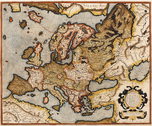
Mercator Projection in the 1595 Atlas. Gerard Mercator. PD.
Europe is the second smallest continent in the world; yet, when we open a world map, it has a prominent and imposing central presence. This is no coincidence. For example, when we compare Russia, located close to the North Pole, with the world’s third-largest country, China, which is far closer to the equator, Russia absolutely dwarfs it. Similarly, Greenland, a scarcely populated autonomous region of Denmark located very close to the North Pole, looks just about as large as the entire continent of Africa on the world map. In reality, though, some 14 Greenlands could fit inside Africa.
For decades, experts from myriad fields ranging from cartography to post-colonial studies have criticized the Mercator projection, the standard world map, and highlighted the dangers it poses by distorting the true size of countries. Abimbola Ogundario, the Campaigns Lead at Africa No Filter, says that “We live in a world where size is often equated with power,” arguing that the Mercator projection furthers the harmful rhetoric that Africa is a country. “It has a damaging impact on the way we make decisions in our everyday lives, on how we make business decisions, the way we dream…It’s the most lingering lie about Africa.”
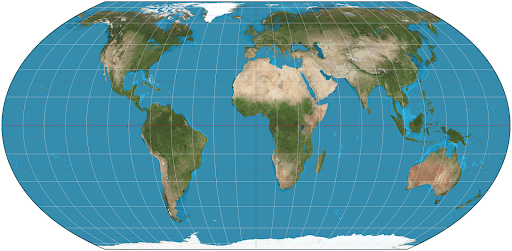
The Equal Earth projection made in 2018. Strebe. CC BY-SA 4.0.
To this effect, the African Union, the continent’s diplomatic organization, recently endorsed a campaign by organizations including Africa No Filter and Speak Up Africa to adopt a different world map, the Equal Earth Map, which depicts countries according to their true size. The continent's prominence and large size relative to Europe and Greenland in the Equal Earth’s Map shows just how distorted the Mercator Projection is. In an internal document shared with the New York Times, the African Union added that their endorsement is part of a larger effort to combat false narratives about Africa, give it dignity on the world stage, and receive a form of reparations.
A similar feeling has been seen across the world, ironically, even in places like Australia, which is actually oversized in the Mercator Projection.
This is because they are away from the center and relegated to the bottom of the map, like South America, even though the map could just as easily be flipped the other way around. In fact, during the ‘Islamic Golden Age’, mapmakers would often place what we call the ‘South’ at the top, emphasizing cities like Mecca, Jerusalem, Baghdad, and Damascus, while Europe was at the bottom.
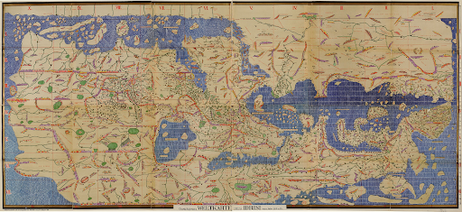
Reconstruction of Al Idrisi’s 12th Century Map with Africa/Asia on Top, Konrad Miller, PD
But what exactly is the Mercator projection, and where does it go wrong? The answer is actually fairly simple. Given the Earth’s spherical shape, it’s mathematically impossible to represent it on a two-dimensional surface without distortion. When the Flemish cartographer Gerard Mercator invented the map in the 16th century, his projection was a stroke of brilliance because it managed to preserve the angles and directions of countries, allowing navigators to draw a straight course to their destinations. It was this very map that helped kick in the Dutch Age of trade, and soon the British Navy was using it to easily get around Africa and navigate India. Its institutional adoption by these major powers made it the global navigational standard and we use it to this day.
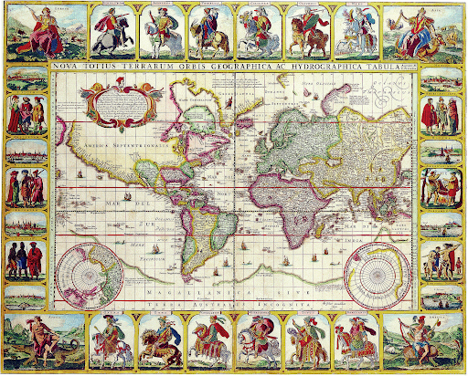
The Mercator projection produced during the Dutch Golden Age. Nicolas Visscher. PD.
Whether the map was intended to be prejudiced or simply got caught up in imperial propaganda is a topic of debate. Mark Monomier, a Distinguished Professor of Geography at Syracuse University, emphasizes that it rose to prominence because of its navigational accuracy but was misused and cites its heavy distortion to advocate its discardment. Cartographer Chandra Jayasuriya shares a similar view. The late Arno Peters was a historian infamous for his critique of the map’s imperialist history and purposeful racial hierarchy, to the extent that he made a different map, the Gall Peters Projection. The African Union’s endorsement will certainly be a boost to the larger ‘Correct the Map’ Movement; however, the familiarity and simple shape of the Mercator projection make it hard to replace. Especially considering that every map has its tradeoffs, the Equal Earth Map, for example, preserves accurate sizes of countries but distorts their shapes and distances. However, activists like Abimbola Ogundario would likely argue that the inaccuracy of the Mercator Projection and its role in disenfranchising the global south make it necessary to normalize alternatives, like the Equal Earth Map.

Daud Azfar
Daud is a second-year student at the University of Virginia, planning on majoring in Politics and Economics. Having grown up in Pakistan, he’s very passionate about the importance of education and social justice. Outside of school, he enjoys spending time with his friends, playing pickleball, and exploring new coffee shops.